2020s Maps of Cicero, New York
Explore 6 historic maps of Cicero from the 2020s. These maps offer a rare glimpse into what life looked like during the 2020s — showing old roads, neighborhoods, homes, and landmarks that have changed or disappeared over time.
Whether you're researching your family's past, planning a metal detecting trip, or studying how Cicero's landscape evolved across the 2020s, these high-resolution maps are a powerful tool for exploring the history of this region.
- Focus on a specific era: All maps on this page are from the 2020s, giving you a focused view of this time period.
- See what’s changed: Compare century-old streets, trails, and buildings to today's modern landscape using overlays and satellite layers.
- Research with precision: Use these maps for genealogy, historical research, land use analysis, or educational projects.
- View, download, or print: Maps are fully viewable online in high resolution, and can be downloaded or printed for your own records.
Start exploring Cicero's history through authentic maps from the 2020s. This is your window into the past.
Cicero, NY maps
(6)- 2023 Map of Manlius, 2023 Print
 2023 Manlius2023 Print · USGSCentral New York at the start of the 2020s shows a landscape of suburban growth layered over deep agricultural roots. Genealogists can locate family burial sites like Anguish Family Cem, while historians can trace old routes like the Genesee Tpke and Fyler Settlement.
 - 2023 Map of Cleveland, 2023 Print
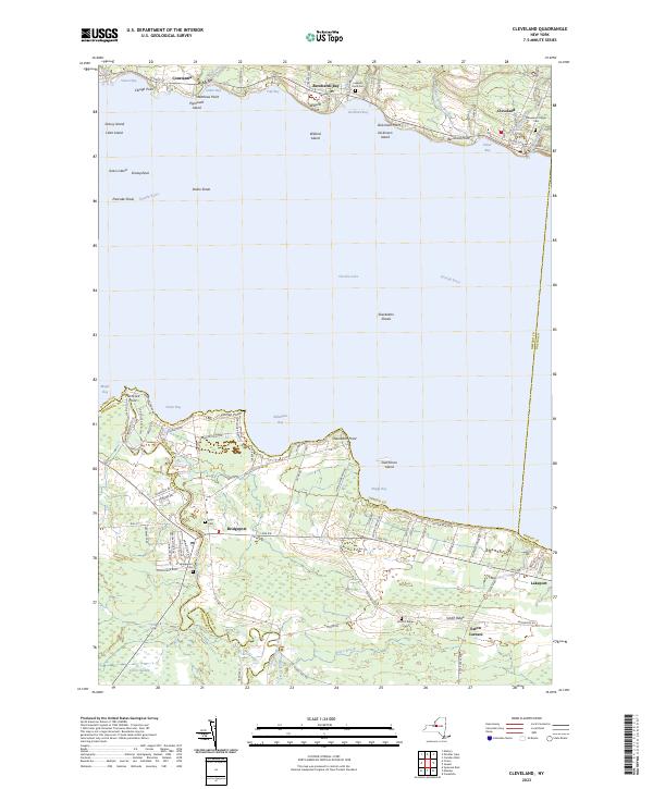 2023 Cleveland2023 Print · USGSThe north and south shores of Oneida Lake are captured here in the early 2020s, showing the enduring waterfront communities of Constantia and Cleveland. Researchers can locate several burial grounds including Deyo Cem and Smith's Ridge Cem or trace the drainage of Chittenango Creek into the lake.
 - 2023 Map of Cicero, 2023 Print
 2023 Cicero2023 Print · USGSOneida Lake shoreline communities and the expansive Cicero Swamp are captured here in the 2020s. Genealogists can locate several burial sites including Cicero Cem and Toad Harbor Cem, or trace the path of the historic Electric Railway.
 - 2023 Map of Syracuse West, 2023 Print
 2023 Syracuse West2023 Print · USGSSyracuse and its western suburbs appear in modern detail in this 2023 survey of the Salt City's urban and institutional landscape. Researchers can trace the grounds of Syracuse University, locate family plots in Oakwood Cem, and explore the shoreline of Onondaga Lake.
 - 2023 Map of Syracuse East, 2023 Print
 2023 Syracuse East2023 Print · USGSEastern Onondaga County is shown here as a thriving suburban and industrial corridor in the early twenty-first century. Researchers can trace the development of older settlements and burial sites like Collamer, Franklin Park, and the Fayetteville Pioneer Burial Ground.
 - 2023 Map of Brewerton, 2023 Print
 2023 Brewerton2023 Print · USGSUpper Onondaga County near the Oswego border is defined by the winding Oneida River and its lush wetlands in the early twenty-first century. Researchers can trace family history at Sandridge Cem, explore the riverside at Oak Orchard, and locate local landmarks like the National Tractor Trailer School Inc.
End of results
Showing maps 1-6 of 6
Top cities near Cicero
- Syracuse historical maps
- Clay historical maps
- Manlius historical maps
- Salina historical maps
- DeWitt historical maps
- De Witt historical maps
See more
Top neighborhoods of Cicero
- Cicero Center historical maps
- Sandy Bay historical maps
- Forest Beach historical maps
- Lower South Bay historical maps
- Brown Center historical maps
- Kraus Landing historical maps
Frequently asked questions
- What are the different types of historical maps available for Cicero?
- What is the oldest map of Cicero?
- Where can I purchase historical maps of Cicero for my home or office?
- Where can I download high-res historical maps of Cicero?
- Are there historical topographic maps available for Cicero?
- Is there historical aerial imagery available for Cicero?
- Where are historical maps of Cicero sourced from?