1970s Maps of Manlius, New York
Explore 4 historic maps of Manlius from the 1970s. These maps offer a rare glimpse into what life looked like during the 1970s — showing old roads, neighborhoods, homes, and landmarks that have changed or disappeared over time.
Whether you're researching your family's past, planning a metal detecting trip, or studying how Manlius's landscape evolved across the 1970s, these high-resolution maps are a powerful tool for exploring the history of this region.
- Focus on a specific era: All maps on this page are from the 1970s, giving you a focused view of this time period.
- See what’s changed: Compare century-old streets, trails, and buildings to today's modern landscape using overlays and satellite layers.
- Research with precision: Use these maps for genealogy, historical research, land use analysis, or educational projects.
- View, download, or print: Maps are fully viewable online in high resolution, and can be downloaded or printed for your own records.
Start exploring Manlius's history through authentic maps from the 1970s. This is your window into the past.
Manlius, NY maps
(4)- 1973 Map of Oran, 1975 Print
 1973 Oran1975 Print · USGSSoutheast of Syracuse in the 1970s, the rural landscapes of Manlius and Pompey reveal a network of upland farms and deep wooded gulfs. Genealogists and local historians can trace family-named crossroads like Clough Corners, visit Pratts Falls Co Park, or follow the Old Railroad Grade through Oran.2 unique versions available
 - 1973 Map of Manlius, 1975 Print
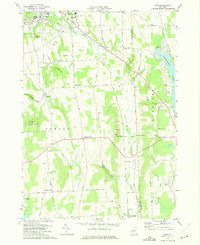
 1973 Manlius1975 Print · USGSOnondaga County in the early seventies shows the intersection of historic canal routes and modern suburban growth. Genealogists and historians can locate family landmarks like Fyler Settlement, Tuscarora Cem, and the path of the Old Erie Canal.4 unique versions available
 - 1973 Map of Jamesville, 1977 Print
 1973 Jamesville1977 Print · USGSCentral New York south of Syracuse in the early seventies shows a landscape of steep ridges and deep glacial valleys. Genealogists and historians can trace family locations through sites like Onativia Church, Pioneer Cemetery, and Fillmore Corner.
 - 1977 Map of Syracuse East, 1978 Print
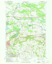
 1977 Syracuse East1978 Print · USGSThe eastern suburbs of Syracuse come alive in the late seventies, showing the dense intersection of industrial rail and modern air travel. Trace local family history through St Marys Cemetery or explore the vast De Witt Yards and the historic Erie Canal.
End of results
Showing maps 1-4 of 4
Top cities near Manlius
- Syracuse historical maps
- Clay historical maps
- Salina historical maps
- Cicero historical maps
- DeWitt historical maps
- De Witt historical maps
See more
Top neighborhoods of Manlius
- Saintsville historical maps
- Fillmore Corner historical maps
- Snyder Crossing historical maps
- Polkville historical maps
- Kirkville historical maps
- High Bridge historical maps
See more
Frequently asked questions
- What are the different types of historical maps available for Manlius?
- What is the oldest map of Manlius?
- Where can I purchase historical maps of Manlius for my home or office?
- Where can I download high-res historical maps of Manlius?
- Are there historical topographic maps available for Manlius?
- Is there historical aerial imagery available for Manlius?
- Where are historical maps of Manlius sourced from?