1970s Maps of Syracuse, New York
Explore 4 historic maps of Syracuse from the 1970s. These maps offer a rare glimpse into what life looked like during the 1970s — showing old roads, neighborhoods, homes, and landmarks that have changed or disappeared over time.
Whether you're researching your family's past, planning a metal detecting trip, or studying how Syracuse's landscape evolved across the 1970s, these high-resolution maps are a powerful tool for exploring the history of this region.
- Focus on a specific era: All maps on this page are from the 1970s, giving you a focused view of this time period.
- See what’s changed: Compare century-old streets, trails, and buildings to today's modern landscape using overlays and satellite layers.
- Research with precision: Use these maps for genealogy, historical research, land use analysis, or educational projects.
- View, download, or print: Maps are fully viewable online in high resolution, and can be downloaded or printed for your own records.
Start exploring Syracuse's history through authentic maps from the 1970s. This is your window into the past.
Syracuse, NY maps
(4)- 1973 Map of Syracuse West, 1975 Print
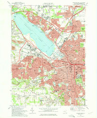 1973 Syracuse West1975 Print · USGSGreater Syracuse and the Onondaga Lake shoreline are captured in the early seventies during a period of peak suburban and infrastructure expansion. Researchers can trace the boundaries of Syracuse University, the State Fairgrounds, and local landmarks like Solvay and Split Rock.2 unique versions available
 - 1973 Map of South Onondaga, 1977 Print
 1973 South Onondaga1977 Print · USGSThe southern outskirts of Syracuse meet the rural valleys of Onondaga County during the early 1970s. Researchers can trace family history through several hamlets and landmarks like Baileys Settlement, Onondaga Castle, and Cedarvale Cem.
 - 1973 Map of Jamesville, 1977 Print
 1973 Jamesville1977 Print · USGSCentral New York south of Syracuse in the early seventies shows a landscape of steep ridges and deep glacial valleys. Genealogists and historians can trace family locations through sites like Onativia Church, Pioneer Cemetery, and Fillmore Corner.
 - 1977 Map of Syracuse East, 1978 Print
 1977 Syracuse East1978 Print · USGSThe eastern suburbs of Syracuse come alive in the late seventies, showing the dense intersection of industrial rail and modern air travel. Trace local family history through St Marys Cemetery or explore the vast De Witt Yards and the historic Erie Canal.
End of results
Showing maps 1-4 of 4
Top cities near Syracuse
- Clay historical maps
- Manlius historical maps
- Salina historical maps
- Cicero historical maps
- De Witt historical maps
- DeWitt historical maps
See more
Top neighborhoods of Syracuse
- Clinton Square historical maps
- University Neighborhood historical maps
- Meadowbrook historical maps
- Armory Square historical maps
- Westside historical maps
- Near Northeast historical maps
See more
Frequently asked questions
- What are the different types of historical maps available for Syracuse?
- What is the oldest map of Syracuse?
- Where can I purchase historical maps of Syracuse for my home or office?
- Where can I download high-res historical maps of Syracuse?
- Are there historical topographic maps available for Syracuse?
- Is there historical aerial imagery available for Syracuse?
- Where are historical maps of Syracuse sourced from?