2020s Maps of Victor, New York
Explore 4 historic maps of Victor from the 2020s. These maps offer a rare glimpse into what life looked like during the 2020s — showing old roads, neighborhoods, homes, and landmarks that have changed or disappeared over time.
Whether you're researching your family's past, planning a metal detecting trip, or studying how Victor's landscape evolved across the 2020s, these high-resolution maps are a powerful tool for exploring the history of this region.
- Focus on a specific era: All maps on this page are from the 2020s, giving you a focused view of this time period.
- See what’s changed: Compare century-old streets, trails, and buildings to today's modern landscape using overlays and satellite layers.
- Research with precision: Use these maps for genealogy, historical research, land use analysis, or educational projects.
- View, download, or print: Maps are fully viewable online in high resolution, and can be downloaded or printed for your own records.
Start exploring Victor's history through authentic maps from the 2020s. This is your window into the past.
Victor, NY maps
(4)- 2023 Map of Macedon, 2023 Print
 2023 Macedon2023 Print · USGSWayne County’s canal corridor is documented here in the early twenty-first century, showing the enduring influence of the Erie Canal on local geography. Genealogists and historians can locate legacy sites like the Union Burying Ground, Yellow Mills, and the North Farmington Friends Cem.
 - 2023 Map of Fairport, 2023 Print
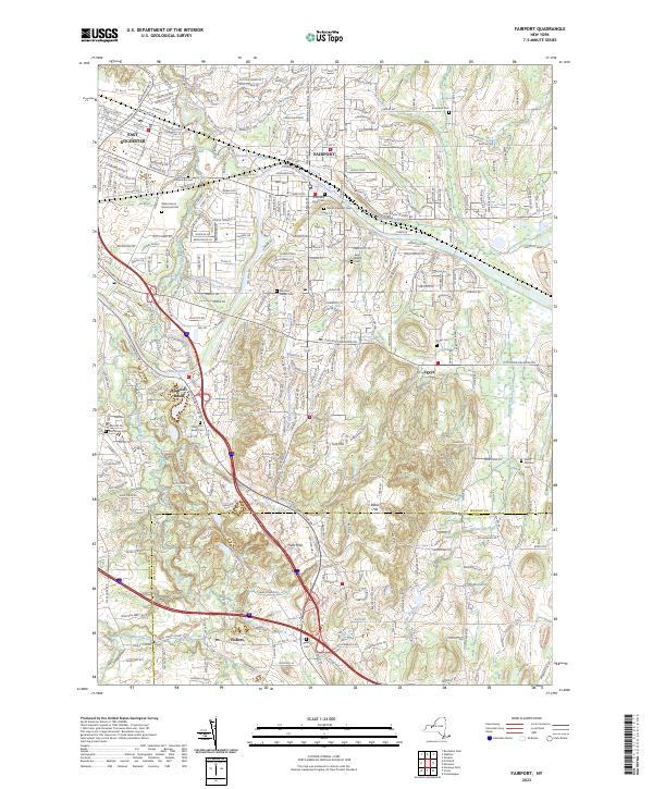 2023 Fairport2023 Print · USGSMonroe and Ontario counties are seen here in their modern context, where the Erie Canal still shapes the geography of local industry and life. Researchers can trace historic cemeteries like South Perinton Cem and local landmarks at Bushnell Basin.
 - 2023 Map of Victor, 2023 Print
 2023 Victor2023 Print · USGSOntario County is depicted here in the early twenty-first century, showing a mix of growing town centers and traditional rural tracts. Genealogists can trace early families at Boughton Hill Cem or Tomlinson's Corners Cem while exploring the environs of Victor and Ionia.
 - 2023 Map of Canandaigua, 2023 Print
 2023 Canandaigua2023 Print · USGSCanandaigua and its surrounding rural hamlets are captured here in the 2020s, showing a landscape defined by historic county seats and modern infrastructure. Researchers can locate numerous family burial grounds like Hathaway Cem or trace the course of the Canandaigua Outlet.
End of results
Showing maps 1-4 of 4
Top cities near Victor
- Rochester historical maps
- Greece historical maps
- Irondequoit historical maps
- Perinton historical maps
- Henrietta historical maps
- Webster historical maps
See more
Top neighborhoods of Victor
- Fishers historical maps
- Motts Corner historical maps
- Boughton Hill historical maps
- East Victor historical maps
- Victor historical maps
Frequently asked questions
- What are the different types of historical maps available for Victor?
- What is the oldest map of Victor?
- Where can I purchase historical maps of Victor for my home or office?
- Where can I download high-res historical maps of Victor?
- Are there historical topographic maps available for Victor?
- Is there historical aerial imagery available for Victor?
- Where are historical maps of Victor sourced from?