1940s Maps of Amboy, New York
Explore 7 historic maps of Amboy from the 1940s. These maps offer a rare glimpse into what life looked like during the 1940s — showing old roads, neighborhoods, homes, and landmarks that have changed or disappeared over time.
Whether you're researching your family's past, planning a metal detecting trip, or studying how Amboy's landscape evolved across the 1940s, these high-resolution maps are a powerful tool for exploring the history of this region.
- Focus on a specific era: All maps on this page are from the 1940s, giving you a focused view of this time period.
- See what’s changed: Compare century-old streets, trails, and buildings to today's modern landscape using overlays and satellite layers.
- Research with precision: Use these maps for genealogy, historical research, land use analysis, or educational projects.
- View, download, or print: Maps are fully viewable online in high resolution, and can be downloaded or printed for your own records.
Start exploring Amboy's history through authentic maps from the 1940s. This is your window into the past.
Amboy, NY maps
(7)- 1943 Map of Westdale
 1943 Westdale1943 Print · USGSOneida County at the height of the Second World War reveals a landscape of small farming hamlets and a robust network of district schools. Genealogists can trace family roots through sites like Graves Cem, Union Ch, and settlements such as Westdale or Spellicy.
 - 1943 Map of Camden West
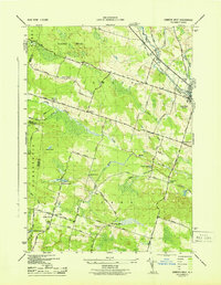 1943 Camden West1943 Print · USGSThe rural landscapes of Oneida and Oswego counties are captured here in the mid-1940s, showing a world of small schoolhouses and family-named crossroads. Researchers can trace historic cemeteries like Pete Lynch Cem or locate vanished landmarks near Brockway Corners and Maple Flats.2 unique versions available
 - 1943 Map of Mallory
 1943 Mallory1943 Print · USGSOswego County in the early 1940s shows a landscape of rail-dependent hamlets and numbered school districts north of Oneida Lake. Genealogists can locate family names at Little France, Mud Settlement, and the Ingersoll Cem near the railroad.
 - 1943 Map of Panther Lake
 1943 Panther Lake1943 Print · USGSOswego County's wooded lake country is shown in detail during the early 1940s, featuring a landscape of small hamlets and numerous rural schoolhouses. Genealogists can trace family landmarks and local centers like Amboy Center, Dutcherville, and the Hall Cem.
 - 1943 Map of Williamstown
 1943 Williamstown1943 Print · USGSOswego County's rural landscape during the mid-1940s reveals a community centered on the New York Central rail line and a network of district schools. Researchers can trace family sites near Holy Cross Cem, find old landmarks like the Checkered House, and explore the shoreline of Kasoag Lake.
 - 1943 Map of Dugway
 1943 Dugway1943 Print · USGSOswego County's rural townships are documented here during the war years, showing a landscape of small farming hamlets and numbered school districts. Local historians can trace family roots through numerous small burial grounds like Maple Lawn Cem and settlements such as Dugway, Parish, and Carleys Mills.
 - 1946 Map of Westdale, 1953 Print
 1946 Westdale1953 Print · USGSOneida County's rural heartland is captured here just after the war, showing the network of hill-country hamlets and district schools. Trace family roots and vanished landmarks near Westdale, Union Ch, and the many rural schoolhouses like School No 5.
End of results
Showing maps 1-7 of 7
Top cities near Amboy
- Clay historical maps
- Cicero historical maps
- Sullivan historical maps
- Hastings historical maps
- Lenox historical maps
- Verona historical maps
See more
Top neighborhoods of Amboy
- Amboy Center historical maps
- Mud Hill historical maps
- Carterville historical maps
- East Amboy historical maps
- West Amboy historical maps
- North Amboy historical maps
Frequently asked questions
- What are the different types of historical maps available for Amboy?
- What is the oldest map of Amboy?
- Where can I purchase historical maps of Amboy for my home or office?
- Where can I download high-res historical maps of Amboy?
- Are there historical topographic maps available for Amboy?
- Is there historical aerial imagery available for Amboy?
- Where are historical maps of Amboy sourced from?