1950s Maps of Oswego, New York
Explore 3 historic maps of Oswego from the 1950s. These maps offer a rare glimpse into what life looked like during the 1950s — showing old roads, neighborhoods, homes, and landmarks that have changed or disappeared over time.
Whether you're researching your family's past, planning a metal detecting trip, or studying how Oswego's landscape evolved across the 1950s, these high-resolution maps are a powerful tool for exploring the history of this region.
- Focus on a specific era: All maps on this page are from the 1950s, giving you a focused view of this time period.
- See what’s changed: Compare century-old streets, trails, and buildings to today's modern landscape using overlays and satellite layers.
- Research with precision: Use these maps for genealogy, historical research, land use analysis, or educational projects.
- View, download, or print: Maps are fully viewable online in high resolution, and can be downloaded or printed for your own records.
Start exploring Oswego's history through authentic maps from the 1950s. This is your window into the past.
Oswego, NY maps
(3)- 1954 Map of Oswego West, 1955 Print
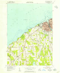 1954 Oswego West1955 Print · USGSThe Lake Ontario shoreline near Oswego is captured here during the mid-fifties, showing the city's growth alongside its deep military and educational roots. Genealogists can locate family landmarks like the Irish Settlement, Rice Cemetery, and Saint Marys Chapel.4 unique versions available
 - 1954 Map of Oswego East, 1956 Print
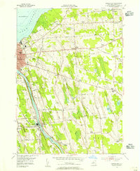 1954 Oswego East1956 Print · USGSOswego and its rural surroundings are documented here in the mid-fifties, from the industrial Oswego River to the Lake Ontario shore. Researchers can trace numerous numbered schoolhouses and family burying grounds like Hillside Cem and Kingdom Cem.3 unique versions available
 - 1956 Map of Fulton, 1961 Print
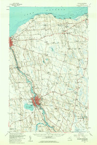 1956 Fulton1961 Print · USGSOswego County's industrial river corridor and lakeside hamlets are captured here during the mid-fifties. Researchers can trace the dual lines of the Erie Lackawanna Railroad and the New York Central Railroad past Lake Neatahwanta and through Fulton.2 unique versions available
End of results
Showing maps 1-3 of 3
Top cities near Oswego
- Clay historical maps
- Fulton historical maps
- Schroeppel historical maps
- Oswego historical maps
- Scriba historical maps
- Granby historical maps
See more
Frequently asked questions
- What are the different types of historical maps available for Oswego?
- What is the oldest map of Oswego?
- Where can I purchase historical maps of Oswego for my home or office?
- Where can I download high-res historical maps of Oswego?
- Are there historical topographic maps available for Oswego?
- Is there historical aerial imagery available for Oswego?
- Where are historical maps of Oswego sourced from?