1940s Maps of Noble Shores, Redfield
Explore 1 historic maps of Noble Shores from the 1940s. These maps offer a rare glimpse into what life looked like during the 1940s — showing old roads, neighborhoods, homes, and landmarks that have changed or disappeared over time.
Whether you're researching your family's past, planning a metal detecting trip, or studying how Noble Shores's landscape evolved across the 1940s, these high-resolution maps are a powerful tool for exploring the history of this region.
- Focus on a specific era: All maps on this page are from the 1940s, giving you a focused view of this time period.
- See what’s changed: Compare century-old streets, trails, and buildings to today's modern landscape using overlays and satellite layers.
- Research with precision: Use these maps for genealogy, historical research, land use analysis, or educational projects.
- View, download, or print: Maps are fully viewable online in high resolution, and can be downloaded or printed for your own records.
Start exploring Noble Shores's history through authentic maps from the 1940s. This is your window into the past.
Noble Shores, Redfield maps
(1)- 1943 Map of Orwell, 1957 Print
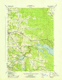 1943 Orwell1957 Print · USGSIn the early 1940s, the rural hills of Oswego County were defined by the deep waters of the Salmon River Reservoir and its surrounding forests. Researchers can trace the era's local life through numerous rural school sites and the historic Vorea Post Office or explore the hydro-power history near Bennett Bridge.2 unique versions available
End of results
Showing maps 1-1 of 1
Top cities near Noble Shores
- Hastings historical maps
- Richland historical maps
- Camden historical maps
- Constantia historical maps
- West Monroe historical maps
- Sandy Creek historical maps
See more
Frequently asked questions
- What are the different types of historical maps available for Noble Shores?
- What is the oldest map of Noble Shores?
- Where can I purchase historical maps of Noble Shores for my home or office?
- Where can I download high-res historical maps of Noble Shores?
- Are there historical topographic maps available for Noble Shores?
- Is there historical aerial imagery available for Noble Shores?
- Where are historical maps of Noble Shores sourced from?