1943 Map of Orwell
USGS Topo · Published 1957About this map
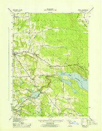
The Salmon River Reservoir dominates this landscape, shaped by the massive Salmon River Dam and the Lower Dam downstream. The mapping reveals a rural network of schoolhouses, from School No 3 in the north to School No 6 in the south, indicating a distributed agrarian population. Hydroelectric infrastructure is evident near Bennett Bridge and the Powerhouse Road, highlighting the industrial utility of the Salmon River. Localities like Orwell and Altmar serve as primary hubs, while smaller settlements such as Vorea, with its Vorea P O, and Beecherville mark the quiet crossroads of the early 1940s. The presence of Noble Shores suggests the early emergence of recreational development along the water's edge, contrasting with the remote character of the Boylston and Orwell uplands.
Find a feature on this map
55 named features on this map. Tap any name to fly to it.
Don’t see what you’re looking for? This feature index may not catch every label — zoom into the map to look around manually.
Map Details
Editions of this 1943 Orwell Map
2 editions found

Other maps of this area

1895 · Pulaski
USGS Topo · 1:62,500

1903 · Orwell
USGS Topo · 1:62,500

1905 · Orwell
USGS Topo · 1:62,500

1905 · Mexico
USGS Topo · 1:62,500

1906 · Kasoag
USGS Topo · 1:62,500

1942 · Sandy Creek
USGS Topo · 1:24,000

1942 · Redfield
USGS Topo · 1:24,000

1943 · Boylston
USGS Topo · 1:31,680

1943 · Redfield
USGS Topo · 1:31,680

1943 · Westdale
USGS Topo · 1:31,680