1950s Maps of Scriba, New York
Explore 5 historic maps of Scriba from the 1950s. These maps offer a rare glimpse into what life looked like during the 1950s — showing old roads, neighborhoods, homes, and landmarks that have changed or disappeared over time.
Whether you're researching your family's past, planning a metal detecting trip, or studying how Scriba's landscape evolved across the 1950s, these high-resolution maps are a powerful tool for exploring the history of this region.
- Focus on a specific era: All maps on this page are from the 1950s, giving you a focused view of this time period.
- See what’s changed: Compare century-old streets, trails, and buildings to today's modern landscape using overlays and satellite layers.
- Research with precision: Use these maps for genealogy, historical research, land use analysis, or educational projects.
- View, download, or print: Maps are fully viewable online in high resolution, and can be downloaded or printed for your own records.
Start exploring Scriba's history through authentic maps from the 1950s. This is your window into the past.
Scriba, NY maps
(5)- 1954 Map of Oswego East, 1956 Print
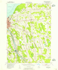 1954 Oswego East1956 Print · USGSOswego and its rural surroundings are documented here in the mid-fifties, from the industrial Oswego River to the Lake Ontario shore. Researchers can trace numerous numbered schoolhouses and family burying grounds like Hillside Cem and Kingdom Cem.3 unique versions available
 - 1955 Map of West Of Texas, 1956 Print
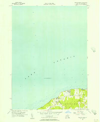 1955 West Of Texas1956 Print · USGSOswego County’s lakefront in the mid-fifties is defined by its quiet coastal settlements and strategic military presence. Genealogists and local historians can trace the rural layouts of Lycoming and Lakeview or locate School No 16 and Camp Oswego.3 unique versions available
 - 1955 Map of Texas, 1957 Print
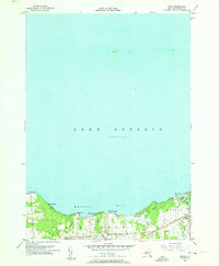 1955 Texas1957 Print · USGSLake Ontario's southern shore in the mid-1950s features a string of coastal settlements and quiet rural townships. Genealogists and local historians can trace family-named sites and early shoreline developments from Greene to Texas, including the Spy Island Historical Site and Cem.3 unique versions available
 - 1956 Map of New Haven, 1958 Print
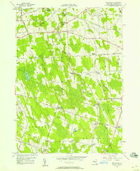 1956 New Haven1958 Print · USGSOswego County in the mid-fifties is a landscape of quiet crossroads and rail-side hamlets centered around the New Haven township. Local historians can trace the community's layout through sites like the Demster Grove Camp Ground, Arthur Cem, and the New Haven Sta on the Central line.2 unique versions available
 - 1956 Map of Fulton, 1961 Print
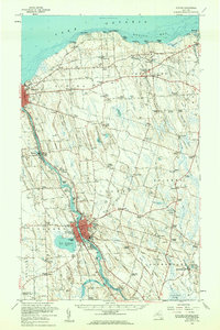 1956 Fulton1961 Print · USGSOswego County's industrial river corridor and lakeside hamlets are captured here during the mid-fifties. Researchers can trace the dual lines of the Erie Lackawanna Railroad and the New York Central Railroad past Lake Neatahwanta and through Fulton.2 unique versions available
End of results
Showing maps 1-5 of 5
Top cities near Scriba
- Clay historical maps
- Oswego historical maps
- Fulton historical maps
- Hastings historical maps
- Schroeppel historical maps
- Oswego historical maps
See more
Top neighborhoods of Scriba
- Lycoming historical maps
- Lansing historical maps
- North Scriba historical maps
- South Scriba historical maps
- Jones Corners historical maps
- Klocks Corner historical maps
See more
Frequently asked questions
- What are the different types of historical maps available for Scriba?
- What is the oldest map of Scriba?
- Where can I purchase historical maps of Scriba for my home or office?
- Where can I download high-res historical maps of Scriba?
- Are there historical topographic maps available for Scriba?
- Is there historical aerial imagery available for Scriba?
- Where are historical maps of Scriba sourced from?