1980s Maps of Scriba, New York
Explore 2 historic maps of Scriba from the 1980s. These maps offer a rare glimpse into what life looked like during the 1980s — showing old roads, neighborhoods, homes, and landmarks that have changed or disappeared over time.
Whether you're researching your family's past, planning a metal detecting trip, or studying how Scriba's landscape evolved across the 1980s, these high-resolution maps are a powerful tool for exploring the history of this region.
- Focus on a specific era: All maps on this page are from the 1980s, giving you a focused view of this time period.
- See what’s changed: Compare century-old streets, trails, and buildings to today's modern landscape using overlays and satellite layers.
- Research with precision: Use these maps for genealogy, historical research, land use analysis, or educational projects.
- View, download, or print: Maps are fully viewable online in high resolution, and can be downloaded or printed for your own records.
Start exploring Scriba's history through authentic maps from the 1980s. This is your window into the past.
Scriba, NY maps
(2)- 1985 Map of Syracuse
 1985 Syracuse1985 Print · USGSCentral New York in the mid-eighties shows a landscape of established canal towns and growing metropolitan suburbs linked by rail and water. Researchers can trace the path of the Erie Canal, find the boundaries of Montezuma Marsh, and locate regional landmarks like Oneida Lake and Chimney Bluffs.3 unique versions available
 - 1985 Map of Pulaski
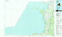 1985 Pulaski1985 Print · USGSThe eastern shores of Lake Ontario in the mid-1980s showcase a landscape of protected wetlands and historic harbor towns. Trace the paths of the CONRAIL railroad and explore the coastal heritage of Sackets Harbor, Port Ontario, and Selkirk Shores State Park.2 unique versions available
End of results
Showing maps 1-2 of 2
Top cities near Scriba
- Clay historical maps
- Oswego historical maps
- Fulton historical maps
- Hastings historical maps
- Schroeppel historical maps
- Oswego historical maps
See more
Top neighborhoods of Scriba
- Lycoming historical maps
- Lansing historical maps
- North Scriba historical maps
- South Scriba historical maps
- Jones Corners historical maps
- Klocks Corner historical maps
See more
Frequently asked questions
- What are the different types of historical maps available for Scriba?
- What is the oldest map of Scriba?
- Where can I purchase historical maps of Scriba for my home or office?
- Where can I download high-res historical maps of Scriba?
- Are there historical topographic maps available for Scriba?
- Is there historical aerial imagery available for Scriba?
- Where are historical maps of Scriba sourced from?