1960s Maps of Colton, New York
Explore 8 historic maps of Colton from the 1960s. These maps offer a rare glimpse into what life looked like during the 1960s — showing old roads, neighborhoods, homes, and landmarks that have changed or disappeared over time.
Whether you're researching your family's past, planning a metal detecting trip, or studying how Colton's landscape evolved across the 1960s, these high-resolution maps are a powerful tool for exploring the history of this region.
- Focus on a specific era: All maps on this page are from the 1960s, giving you a focused view of this time period.
- See what’s changed: Compare century-old streets, trails, and buildings to today's modern landscape using overlays and satellite layers.
- Research with precision: Use these maps for genealogy, historical research, land use analysis, or educational projects.
- View, download, or print: Maps are fully viewable online in high resolution, and can be downloaded or printed for your own records.
Start exploring Colton's history through authentic maps from the 1960s. This is your window into the past.
Colton, NY maps
(8)- 1961 Map of Ogdensburg
 1961 Ogdensburg1961 Print · USGSThe St. Lawrence valley and the Adirondack high country meet in this early sixties survey during a peak era for rail and river commerce. Genealogists and historians can trace the paths of the New York Central railroad through remote settlements like Wanakena, Conifer, and Piercefield.
 - 1964 Map of Rainbow Falls, 1966 Print
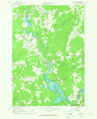
 1964 Rainbow Falls1966 Print · USGSThe Raquette River corridor in St. Lawrence County shows a landscape defined by hydroelectric power and mid-century recreation in the mid-1960s. Researchers can trace the development of the Five Falls and Rainbow Falls reservoirs or locate local landmarks like the Boy Scout Camp and the settlement of Pickettville.3 unique versions available
 - 1964 Map of Colton, 1966 Print
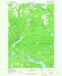
 1964 Colton1966 Print · USGSSt. Lawrence County was defined by its hydroelectric river valley in the mid-1960s. Researchers can trace the civic foundations of the area through family landmarks like Vebber Corners, old burial grounds such as Riverside Cem, and the St Patrick Ch at Colton.2 unique versions available
 - 1968 Map of Wolf Mountain, 1971 Print
 1968 Wolf Mountain1971 Print · USGSThe Adirondack wilderness in the late sixties is defined by a vast network of glacial ponds and state-managed timberlands. Researchers can trace the Penn Central rail line past Robinwood or locate the Partlow Milldam and Lookout Tower on Cat Mtn.2 unique versions available
 - 1968 Map of Childwold, 1971 Print
 1968 Childwold1971 Print · USGSThe Raquette River wilderness in the late sixties reveals a network of remote hamlets and scout camps. Trace the developments at Childwold, identify family burial sites at the Cem near Sevey Corners, and locate the Lookout Tower on Moosehead Mtn.
 - 1968 Map of Cranberry Lake, 1971 Print
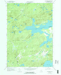
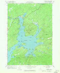 1968 Cranberry Lake1971 Print · USGSCranberry Lake and the surrounding Adirondack wilderness are captured here in the late sixties, showing the intricate shoreline and interior islands. Researchers can find remote landmarks like the Cranberry Lake Biological Station, Joe Indian Island, and the Cranberry Lake Cem.2 unique versions available
 - 1968 Map of Stark, 1971 Print
 1968 Stark1971 Print · USGSThe Raquette River highlands in the late 1960s reveal a landscape of hydroelectric power and deep woods recreation. Researchers can locate the Irish Settlement, trace the flooded banks of Blake Falls Reservoir, and find family landmarks like Whispering Pines Camp or the Granshue Club.
 - 1969 Map of Tooley Pond, 1971 Print
 1969 Tooley Pond1971 Print · USGSSt. Lawrence County in the late sixties reveals a wild river landscape within the Adirondack State Park. Genealogists and historians can trace the remote settlement at Newbridge and remote landmarks like Canton Farm or the many waterfalls including Rainbow Falls.
End of results
Showing maps 1-8 of 8
Top cities near Colton
- Pierrepont historical maps
- Parishville historical maps
- Fine historical maps
- Hopkinton historical maps
- Waverly historical maps
- Long Lake historical maps
See more
Top neighborhoods of Colton
- Irish Settlement historical maps
- Stark historical maps
- Sevey historical maps
- Brandy Brook historical maps
- Shurtleff historical maps
- South Colton historical maps
See more
Frequently asked questions
- What are the different types of historical maps available for Colton?
- What is the oldest map of Colton?
- Where can I purchase historical maps of Colton for my home or office?
- Where can I download high-res historical maps of Colton?
- Are there historical topographic maps available for Colton?
- Is there historical aerial imagery available for Colton?
- Where are historical maps of Colton sourced from?