1960s Maps of Hopkinton, New York
Explore 9 historic maps of Hopkinton from the 1960s. These maps offer a rare glimpse into what life looked like during the 1960s — showing old roads, neighborhoods, homes, and landmarks that have changed or disappeared over time.
Whether you're researching your family's past, planning a metal detecting trip, or studying how Hopkinton's landscape evolved across the 1960s, these high-resolution maps are a powerful tool for exploring the history of this region.
- Focus on a specific era: All maps on this page are from the 1960s, giving you a focused view of this time period.
- See what’s changed: Compare century-old streets, trails, and buildings to today's modern landscape using overlays and satellite layers.
- Research with precision: Use these maps for genealogy, historical research, land use analysis, or educational projects.
- View, download, or print: Maps are fully viewable online in high resolution, and can be downloaded or printed for your own records.
Start exploring Hopkinton's history through authentic maps from the 1960s. This is your window into the past.
Hopkinton, NY maps
(9)- 1961 Map of Ogdensburg
 1961 Ogdensburg1961 Print · USGSThe St. Lawrence valley and the Adirondack high country meet in this early sixties survey during a peak era for rail and river commerce. Genealogists and historians can trace the paths of the New York Central railroad through remote settlements like Wanakena, Conifer, and Piercefield.
 - 1964 Map of Rainbow Falls, 1966 Print
 1964 Rainbow Falls1966 Print · USGSThe Raquette River corridor in St. Lawrence County shows a landscape defined by hydroelectric power and mid-century recreation in the mid-1960s. Researchers can trace the development of the Five Falls and Rainbow Falls reservoirs or locate local landmarks like the Boy Scout Camp and the settlement of Pickettville.3 unique versions available
 - 1964 Map of Sylvan Falls, 1966 Print
 1964 Sylvan Falls1966 Print · USGSThe Adirondack foothills in the mid-1960s reveal a landscape of managed forests and river power. Local researchers can trace the West Branch St Regis River past Sylvan Falls to the Cough Cem and Blake Falls Reservoir.
 - 1964 Map of Parishville, 1966 Print
 1964 Parishville1966 Print · USGSSt. Lawrence County in the mid-1960s is defined by its hydroelectric power along the river and deep-rooted rural hamlets. Genealogists and local historians can trace family locations near Parishville, Fairview Cem, and the Allen Falls Reservoir.3 unique versions available
 - 1964 Map of Saint Regis Falls, 1966 Print
 1964 Saint Regis Falls1966 Print · USGSThe river-powered village of Saint Regis Falls and the surrounding Adirondack foothills are captured here in the mid-1960s. Researchers can locate family sites at St Anns Ch, trace the Old Railroad Grade, and explore lakefront landmarks like Lake Ozonia.2 unique versions available
 - 1964 Map of Lake Ozonia, 1966 Print
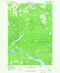
 1964 Lake Ozonia1966 Print · USGSAdirondack wilderness near the St. Lawrence and Franklin county line is documented here in the mid-1960s. Researchers can trace the trails and summits of the State Forest Preserve, locating the Lookout Tower on Azure Mountain and remote camps like Center Camp.2 unique versions available
 - 1964 Map of Nicholville, 1966 Print
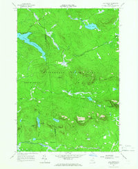
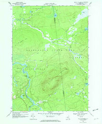
 1964 Nicholville1966 Print · USGSIn the mid-1960s, St. Lawrence County's southern townships transitioned from the rolling farmland of the St. Lawrence Valley into the dense forests of the Adirondacks. Genealogists and researchers can trace the historic riverfront hamlets of Nicholville and Fort Jackson, alongside rural landmarks like Holy Cross Cem and Independent Hill.2 unique versions available
 - 1968 Map of Mount Matumbla, 1970 Print
 1968 Mount Matumbla1970 Print · USGSThe Adirondack wilderness at the Franklin and St. Lawrence county line is captured here in the late sixties. Researchers can trace the Old Railroad Grade past the settlement of Kildare or navigate the series of Raquette River features like Hedgehog Rapids.2 unique versions available
 - 1968 Map of Childwold, 1971 Print
 1968 Childwold1971 Print · USGSThe Raquette River wilderness in the late sixties reveals a network of remote hamlets and scout camps. Trace the developments at Childwold, identify family burial sites at the Cem near Sevey Corners, and locate the Lookout Tower on Moosehead Mtn.
End of results
Showing maps 1-9 of 9
Top cities near Hopkinton
- Potsdam historical maps
- Tupper Lake historical maps
- Norfolk historical maps
- Stockholm historical maps
- Parishville historical maps
- Lawrence historical maps
See more
Top neighborhoods of Hopkinton
Frequently asked questions
- What are the different types of historical maps available for Hopkinton?
- What is the oldest map of Hopkinton?
- Where can I purchase historical maps of Hopkinton for my home or office?
- Where can I download high-res historical maps of Hopkinton?
- Are there historical topographic maps available for Hopkinton?
- Is there historical aerial imagery available for Hopkinton?
- Where are historical maps of Hopkinton sourced from?