Old Maps of Norfolk, New York for Genealogy
Trace your family roots with 56 historic maps of Norfolk. These high-res maps reveal old neighborhoods, homesites, landmarks, and streets — helping you uncover where your ancestors lived and how the area evolved over time.
- Explore historic neighborhoods: Identify where your relatives may have lived in the 1800s or 1900s.
- Compare maps over time: Trace the changes in streets, buildings, and landmarks for multi-generational research.
- Perfect for genealogy & ancestry research: Used by family historians and researchers to map out lineage and migration.
These maps are an incredible resource for exploring your personal connection to Norfolk's past.
Norfolk, NY maps
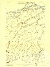
(56)- 1905 Map of Waddington
 1905 Waddington1905 Print · USGSThe international border along the St. Lawrence River is captured here in the early 1900s, before modern seaway developments altered the shoreline. Researchers can trace the original locations of Waddington, the locks of the Rapide Plat Canal, and the Grand Trunk RR rail line.5 unique versions available
 - 1906 Map of Massena, 1956 Print
 1906 Massena1956 Print · USGSSt. Lawrence County is mapped here at the opening of the twentieth century, showcasing a landscape of powerful river rapids and vital international border crossings. Genealogists can trace early rail stations and rural hamlets like North Stockholm Knapps Sta, Massena Center, and Winthrop.
 - 1907 Map of Massena
 1907 Massena1907 Print · USGSSt. Lawrence County is depicted in the early twentieth century, showing a landscape defined by the powerful rapids of the upper river before modern dams. Researchers can trace historic river landings like Louisville Landing, the path of the Massena Power Canal, and small rail stops such as North Stockholm Knapps Sta.6 unique versions available
 - 1908 Map of Potsdam
 1908 Potsdam1908 Print · USGSSt. Lawrence County is captured here in the early twentieth century as a vibrant landscape of river-powered industry and dispersed school districts. Researchers can trace the original N. Y. C. and H. R. R. R. through Norwood or locate historic rural landmarks like Browns Bridge and Old Forge School.7 unique versions available
 - 1942 Map of Chase Mills, 1961 Print
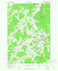
 1942 Chase Mills1961 Print · USGSSt. Lawrence County was a landscape of river-driven hamlets and rural school districts in the early 1940s. Genealogists can trace family lines through landmarks like Haskell Ridge Cem, the Norwood and St Lawrence rail line, and Chase Mills.
 - 1942 Map of Norfolk, 1961 Print
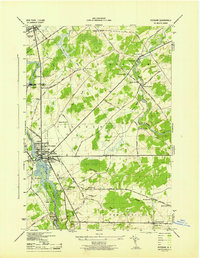
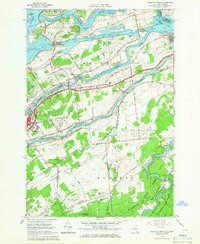
 1942 Norfolk1961 Print · USGSSt. Lawrence County in the early 1940s was a bustling corridor of river power and rail transport. Genealogists and historians can trace the foundations of Norfolk and Norwood or locate rural landmarks like Bixby Cem and School No 17.
 - 1942 Map of Massena, 1961 Print
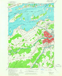
 1942 Massena1961 Print · USGSThe St. Lawrence River frontier is captured here just before mid-century engineering altered the shoreline. Trace the pre-seaway river landscape through Long Sault Rapids, Louisville Landing, and the many numbered schoolhouses like School No 10.
 - 1943 Map of Potsdam
 1943 Potsdam1943 Print · USGSSt. Lawrence County during the early war years reveals a landscape of river-powered industry and dispersed school districts. Researchers can locate family heritage at Bayside Cem and St Marys Cem or trace the early industrial footprint of the Sugar Island Dam and the Garfield Gem mine.2 unique versions available
 - 1943 Map of Massena
 1943 Massena1943 Print · USGSSt. Lawrence County sits at the edge of the Canadian border during the early 1940s, showing a river landscape before the modern seaway. Genealogists and local historians can locate early district landmarks like Louisville Landing Ch, the Kent Mill Cem, and the Massena Power Canal.
 - 1943 Map of Chase Mills
 1943 Chase Mills1943 Print · USGSSt. Lawrence County is captured here in the early 1940s, showing a landscape of small agricultural hamlets and river-fed industry. Genealogists can locate family landmarks like Haskell Ridge Cem and trace the old Norwood and St Lawrence RR through Chase Mills.
 - 1943 Map of Norfolk
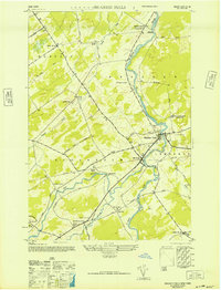
 1943 Norfolk1943 Print · USGSNorthern St. Lawrence County during the mid-1940s is defined by a landscape of riverside industry and rural school districts. Genealogists can locate family landmarks like Bixby Cem and several numbered schoolhouses from Grantville to North Stockholm.
 - 1946 Map of Brasher Falls
 1946 Brasher Falls1946 Print · USGSSt. Lawrence County is mapped during the mid-1940s, centered on the river-fed hamlets of the St. Regis valley. Genealogists can locate family landmarks like St Patrick Cem and Willis Cem, or trace the old Rutland Branch rail line.
 - 1946 Map of Raquette River
 1946 Raquette River1946 Print · USGSSt. Lawrence County in the mid-1940s shows the river landscape before major seaway developments changed the northern border. Researchers can trace rural life through numerous landmarks like School No 12, Nevins Cem, and the S Sault Rapids.
 - 1948 Map of Ogdensburg, 1973 Print
 1948 Ogdensburg1973 Print · USGSThe international border along the St Lawrence River comes to life in the late 1940s, showing the vital rail and water connections between New York and Ontario. Researchers can trace the grounds of St Lawrence University, the massive Camp Drum military reservation, and the historic Rideau River and Canal.2 unique versions available
 - 1951 Map of Ogdensburg
 1951 Ogdensburg1951 Print · USGSThe St. Lawrence frontier and the North Country are captured here during the post-war era, from the river ports to the high Adirondacks. Genealogists and historians can trace the rail-and-river economy through Ogdensburg, the Rutland rail lines, and Potsdam.
 - 1953 Map of Ogdensburg
 1953 Ogdensburg1953 Print · USGSThe North Country and St. Lawrence Valley are shown here in the early fifties, just as the region’s rail-and-river economy remained in full swing. Genealogists and historians can trace family-named corners and rural hubs along the Rutland railroad or locate heritage sites near Ogdensburg, Potsdam, and the St Regis Indian Reservation.
 - 1961 Map of Ogdensburg
 1961 Ogdensburg1961 Print · USGSThe St. Lawrence valley and the Adirondack high country meet in this early sixties survey during a peak era for rail and river commerce. Genealogists and historians can trace the paths of the New York Central railroad through remote settlements like Wanakena, Conifer, and Piercefield.
 - 1964 Map of Norfolk, 1966 Print
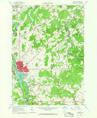
 1964 Norfolk1966 Print · USGSSt. Lawrence County in the mid-1960s shows a landscape of river-driven industry and growing state forests. Trace the path of the Norwood and St Lawrence RR through the hamlets of Raymondville and Norfolk or locate family plots at Bixby Cem.
 - 1964 Map of Potsdam, 1966 Print
 1964 Potsdam1966 Print · USGSSt. Lawrence County is captured during a period of academic and industrial growth in the mid-sixties. Researchers can trace the footprints of Clarkson College, locate family plots in Bayside Cem, and follow the New York Central Railroad through Norwood.3 unique versions available
 - 1964 Map of Raquette River, 1966 Print
 1964 Raquette River1966 Print · USGSThe St. Lawrence riverfront in the mid-1960s shows a landscape transformed by the seaway and international commerce. Local historians can trace family-named roads and sites like Massena Center, the Eisenhower Lock, and Carville Cem.2 unique versions available
 - 1964 Map of Massena, 1966 Print
 1964 Massena1966 Print · USGSSt. Lawrence County in the mid-1960s reveals a landscape defined by the St. Lawrence Seaway and industrial growth. Genealogists and historians can trace family locations near Massena Springs, Calvary Cem, or schools like Madison Sch.3 unique versions available
 - 1964 Map of Chase Mills, 1966 Print
 1964 Chase Mills1966 Print · USGSSt. Lawrence County is captured here in the mid-1960s, showing a network of rural hamlets and river-driven landscapes before modern redevelopment. Researchers can locate family burial plots at Haskell Ridge Cem and trace the paths between old crossroads like Dalton Crossing and Chase Mills.
 - 1964 Map of Brasher Falls, 1966 Print
 1964 Brasher Falls1966 Print · USGSUpper St. Lawrence County is captured in the mid-1960s, a time when the river-valley communities of Brasher Falls and Winthrop were the region's social hubs. Genealogists can trace family landmarks across the countryside, from Richardson Cem and St Patricks Cem to rural settlements like Skinnerville.2 unique versions available
 - 1985 Map of Massena
 1985 Massena1985 Print · USGSNorthern New York at the mid-eighties shows a landscape of river-driven industry and high mountain wilderness along the Canadian border. Researchers can trace the legacy of iron working and milling in Brasher Iron Works or follow the Raquette River through Massena and Potsdam.
 - 1985 Map of Ogdensburg, 1986 Print
 1985 Ogdensburg1986 Print · USGSThe St. Lawrence River valley and the northern New York borderlands are shown here in the mid-1980s, during a period of established institutional and collegiate growth. Researchers can trace the paths of CONRAIL through Potsdam or locate local landmarks like Mater Dei College and Rensselaer Falls.2 unique versions available
Showing maps 1-25 of 56
Top cities near Norfolk
- Potsdam historical maps
- Massena historical maps
- Canton historical maps
- Massena historical maps
- Potsdam historical maps
- Canton historical maps
See more
Top neighborhoods of Norfolk
- Grantville historical maps
- Plumbrook historical maps
- Raymondville historical maps
- Norfolk historical maps
Frequently asked questions
- What are the different types of historical maps available for Norfolk?
- What is the oldest map of Norfolk?
- Where can I purchase historical maps of Norfolk for my home or office?
- Where can I download high-res historical maps of Norfolk?
- Are there historical topographic maps available for Norfolk?
- Is there historical aerial imagery available for Norfolk?
- Where are historical maps of Norfolk sourced from?