1960s Maps of Russell, New York
Explore 7 historic maps of Russell from the 1960s. These maps offer a rare glimpse into what life looked like during the 1960s — showing old roads, neighborhoods, homes, and landmarks that have changed or disappeared over time.
Whether you're researching your family's past, planning a metal detecting trip, or studying how Russell's landscape evolved across the 1960s, these high-resolution maps are a powerful tool for exploring the history of this region.
- Focus on a specific era: All maps on this page are from the 1960s, giving you a focused view of this time period.
- See what’s changed: Compare century-old streets, trails, and buildings to today's modern landscape using overlays and satellite layers.
- Research with precision: Use these maps for genealogy, historical research, land use analysis, or educational projects.
- View, download, or print: Maps are fully viewable online in high resolution, and can be downloaded or printed for your own records.
Start exploring Russell's history through authentic maps from the 1960s. This is your window into the past.
Russell, NY maps
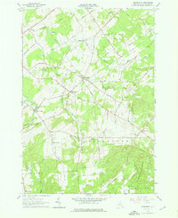
(7)- 1961 Map of Ogdensburg
 1961 Ogdensburg1961 Print · USGSThe St. Lawrence valley and the Adirondack high country meet in this early sixties survey during a peak era for rail and river commerce. Genealogists and historians can trace the paths of the New York Central railroad through remote settlements like Wanakena, Conifer, and Piercefield.
 - 1964 Map of Pierrepont, 1966 Print
 1964 Pierrepont1966 Print · USGSThe rural communities of St. Lawrence County are captured in the mid-1960s, showing a landscape of scattered hamlets and family-named roads. Genealogists and local historians can locate specific landmarks like the White Church Cem, Briek Chapel, and the Giffins Corners Sch.3 unique versions available
 - 1964 Map of Canton, 1966 Print
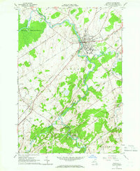 1964 Canton1966 Print · USGSCanton and its surrounding St. Lawrence County countryside are shown here in the mid-sixties, highlighting the region's academic and industrial roots. Researchers can trace the New York Central rail lines and explore old cemeteries like Jerusalem Cem or landmarks like St Lawrence University.2 unique versions available
 - 1966 Map of Hermon, 1971 Print
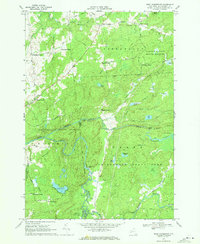
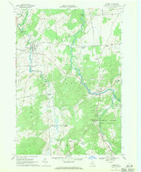 1966 Hermon1971 Print · USGSSt. Lawrence County in the mid-1960s remains a landscape of river-centered villages and rural crossroads settlements. Genealogists and local historians can trace family-named landmarks and old hamlets like Stellaville, Palmerville, and the forest-rimmed Whippoorwill Corners.2 unique versions available
 - 1969 Map of South Edwards, 1971 Print
 1969 South Edwards1971 Print · USGSSt. Lawrence County in the late sixties shows a landscape of river-driven industry and growing state forests. Researchers can trace the Oswegatchie River through South Edwards, locate the Powerplant, and find sites like Pond Settlement.2 unique versions available
 - 1969 Map of Degrasse, 1971 Print
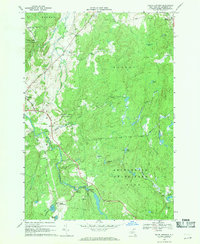
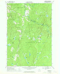 1969 Degrasse1971 Print · USGSThe northern Adirondacks in the late sixties reveal a landscape of active forestry and industrial memory. Trace the convergence of the South Branch Grass River and explore the historic Clifton Furnace Ruins and Pleasant View Cem.3 unique versions available
 - 1969 Map of West Pierrepont, 1971 Print
 1969 West Pierrepont1971 Print · USGSSt. Lawrence County was a region of remote hamlets and timbered forest lands when this survey was field-checked in the late sixties. Researchers can trace the legacy of family homesteads at Endersbees Corners or locate the Old Railroad Grade near Lampsons Falls.2 unique versions available
End of results
Showing maps 1-7 of 7
Top cities near Russell
- Potsdam historical maps
- Canton historical maps
- Canton historical maps
- Lisbon historical maps
- Oswegatchie historical maps
- Pierrepont historical maps
See more
Top neighborhoods of Russell
- Derbys Corners historical maps
- Palmerville historical maps
- Stalbird historical maps
- North Russell historical maps
- Degrasse historical maps
- South Russell historical maps
Frequently asked questions
- What are the different types of historical maps available for Russell?
- What is the oldest map of Russell?
- Where can I purchase historical maps of Russell for my home or office?
- Where can I download high-res historical maps of Russell?
- Are there historical topographic maps available for Russell?
- Is there historical aerial imagery available for Russell?
- Where are historical maps of Russell sourced from?