2020s Maps of Stockholm, New York
Explore 6 historic maps of Stockholm from the 2020s. These maps offer a rare glimpse into what life looked like during the 2020s — showing old roads, neighborhoods, homes, and landmarks that have changed or disappeared over time.
Whether you're researching your family's past, planning a metal detecting trip, or studying how Stockholm's landscape evolved across the 2020s, these high-resolution maps are a powerful tool for exploring the history of this region.
- Focus on a specific era: All maps on this page are from the 2020s, giving you a focused view of this time period.
- See what’s changed: Compare century-old streets, trails, and buildings to today's modern landscape using overlays and satellite layers.
- Research with precision: Use these maps for genealogy, historical research, land use analysis, or educational projects.
- View, download, or print: Maps are fully viewable online in high resolution, and can be downloaded or printed for your own records.
Start exploring Stockholm's history through authentic maps from the 2020s. This is your window into the past.
Stockholm, NY maps
(6)- 2023 Map of North Lawrence, 2023 Print
 2023 North Lawrence2023 Print · USGSThe rural landscapes of St. Lawrence County are captured here in the early twenty-first century, centered on the settlements of North Lawrence and Lawrenceville. Genealogists can locate several local burial sites including Hill Crest Cem and Hailville Cem along the Deer River valley.
 - 2023 Map of Nicholville, 2023 Print
 2023 Nicholville2023 Print · USGSSaint Lawrence County’s rural northern edge is shown here in the 2020s, where the Saint Regis River flows past historic villages. Genealogists and local historians can locate early burial sites like Mound Hill Cem and Chesterfield Cem.
 - 2023 Map of Parishville, 2023 Print
 2023 Parishville2023 Print · USGSSt. Lawrence County in the 2020s remains a landscape of river-fed hamlets and quiet northern woods. Genealogists can trace family footprints at Hillcrest Cem and Fairview Cem, or locate landmarks like Allen Falls and Catherineville.
 - 2023 Map of Brasher Falls, 2023 Print
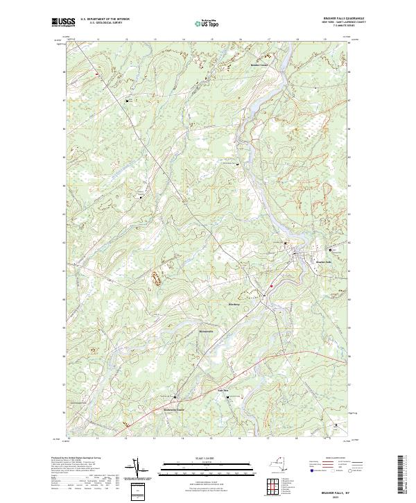 2023 Brasher Falls2023 Print · USGSBrasher Falls and Winthrop appear in high detail during this contemporary era, situated along the banks of the Saint Regis River. Family historians can trace local legacy through numerous sites including Holmes Hill Cem, Skinnerville, and Saint Patrick Cem.
 - 2023 Map of Norfolk, 2023 Print
 2023 Norfolk2023 Print · USGSNorthern St. Lawrence County settlements line the banks of the Raquette River in this recent survey. Researchers can trace the layout of Norfolk, Raymondville, and Norwood, or locate local landmarks like the Brookdale Cem and the Raymondville Ski Trail.
 - 2023 Map of Potsdam, 2023 Print
 2023 Potsdam2023 Print · USGSSt. Lawrence County is showcased in the modern era as a center of education and river-driven settlement. Researchers can trace family history through numerous sites like Bayside Cemetery and Ellis Cem, or locate the historic bounds of Clarkson University.
End of results
Showing maps 1-6 of 6
Top cities near Stockholm
- Potsdam historical maps
- Massena historical maps
- Canton historical maps
- Massena historical maps
- Potsdam historical maps
- Norfolk historical maps
See more
Top neighborhoods of Stockholm
- Southville historical maps
- Knapps Station historical maps
- Kellogg historical maps
- Sandfordville historical maps
- Skinnerville historical maps
- West Stockholm historical maps
See more
Frequently asked questions
- What are the different types of historical maps available for Stockholm?
- What is the oldest map of Stockholm?
- Where can I purchase historical maps of Stockholm for my home or office?
- Where can I download high-res historical maps of Stockholm?
- Are there historical topographic maps available for Stockholm?
- Is there historical aerial imagery available for Stockholm?
- Where are historical maps of Stockholm sourced from?