2020s Maps of Milton, New York
Explore 4 historic maps of Milton from the 2020s. These maps offer a rare glimpse into what life looked like during the 2020s — showing old roads, neighborhoods, homes, and landmarks that have changed or disappeared over time.
Whether you're researching your family's past, planning a metal detecting trip, or studying how Milton's landscape evolved across the 2020s, these high-resolution maps are a powerful tool for exploring the history of this region.
- Focus on a specific era: All maps on this page are from the 2020s, giving you a focused view of this time period.
- See what’s changed: Compare century-old streets, trails, and buildings to today's modern landscape using overlays and satellite layers.
- Research with precision: Use these maps for genealogy, historical research, land use analysis, or educational projects.
- View, download, or print: Maps are fully viewable online in high resolution, and can be downloaded or printed for your own records.
Start exploring Milton's history through authentic maps from the 2020s. This is your window into the past.
Milton, NY maps
(4)- 2023 Map of Burnt Hills, 2023 Print
 2023 Burnt Hills2023 Print · USGSSaratoga and Schenectady counties appear here in the early 2020s, showcasing a landscape of historical hamlets and modern residential growth. Genealogists can trace family landmarks at Jeremiah Smith Cemetery and Calvary Episcopal Church, or explore crossroads like Harmony Corners.
 - 2023 Map of Middle Grove, 2023 Print
 2023 Middle Grove2023 Print · USGSSaratoga County's rural communities and historic hamlets are detailed in this recent survey. Genealogists can locate family burial sites like Grenell Road Cem and Ashley Cem while tracing the waters of Glowegee Creek.
 - 2023 Map of Saratoga Springs, 2023 Print
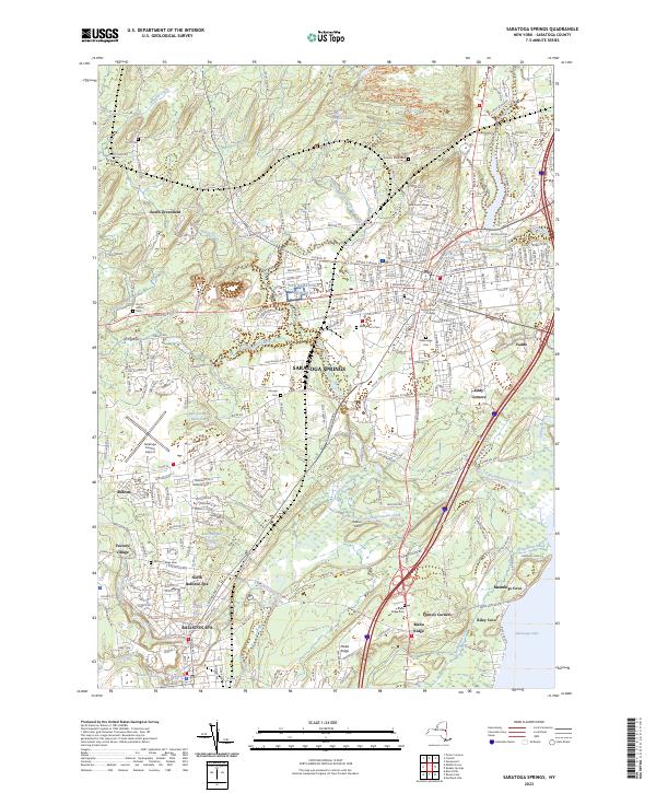 2023 Saratoga Springs2023 Print · USGSSaratoga Springs and the neighboring village of Ballston Spa appear here in detail during the early 2020s. Researchers can locate numerous local landmarks including Skidmore College, the storied estate of Yaddo, and various historic burial grounds like Greenridge Cem and Malta Ridge Cem.
 - 2023 Map of Round Lake, 2023 Print
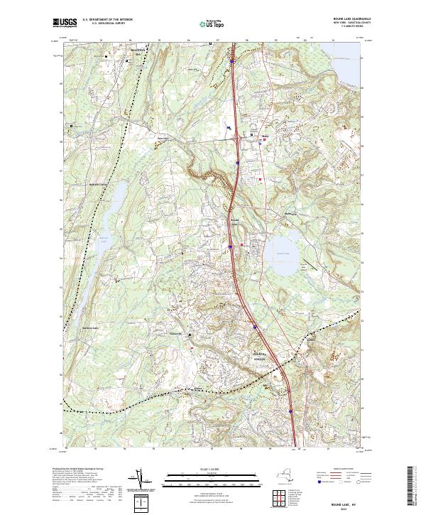 2023 Round Lake2023 Print · USGSSaratoga County's growing residential corridors meet historic village centers in this contemporary record of the region's evolving landscape. Researchers can locate several burial sites including Ballston Cem and Jonesville Cem, or trace the banks of Round Lake and Anthony Kill.
End of results
Showing maps 1-4 of 4
Top cities near Milton
- Colonie historical maps
- Schenectady historical maps
- Clifton Park historical maps
- Rotterdam historical maps
- Glenville historical maps
- West Glenville historical maps
See more
Top neighborhoods of Milton
- Milton Center historical maps
- North Milton historical maps
- Rock City Falls historical maps
- West Milton historical maps
- North Ballston Spa historical maps
Frequently asked questions
- What are the different types of historical maps available for Milton?
- What is the oldest map of Milton?
- Where can I purchase historical maps of Milton for my home or office?
- Where can I download high-res historical maps of Milton?
- Are there historical topographic maps available for Milton?
- Is there historical aerial imagery available for Milton?
- Where are historical maps of Milton sourced from?