1940s Maps of Fayette, New York
Explore 6 historic maps of Fayette from the 1940s. These maps offer a rare glimpse into what life looked like during the 1940s — showing old roads, neighborhoods, homes, and landmarks that have changed or disappeared over time.
Whether you're researching your family's past, planning a metal detecting trip, or studying how Fayette's landscape evolved across the 1940s, these high-resolution maps are a powerful tool for exploring the history of this region.
- Focus on a specific era: All maps on this page are from the 1940s, giving you a focused view of this time period.
- See what’s changed: Compare century-old streets, trails, and buildings to today's modern landscape using overlays and satellite layers.
- Research with precision: Use these maps for genealogy, historical research, land use analysis, or educational projects.
- View, download, or print: Maps are fully viewable online in high resolution, and can be downloaded or printed for your own records.
Start exploring Fayette's history through authentic maps from the 1940s. This is your window into the past.
Fayette, NY maps
(6)- 1943 Map of Geneva North
 1943 Geneva North1943 Print · USGSThe rural landscape north of Geneva is captured here in the early 1940s, showing a network of crossroads settlements and small-scale farms. Researchers can trace ancestral locations at Dobbins Corner, identify several local burying grounds like Quaker Cem, and locate numerous district schools such as School No 5.
 - 1943 Map of Geneva South
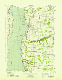
 1943 Geneva South1943 Print · USGSGeneva and the shores of Seneca Lake are captured here during the early 1940s, highlighting the region's academic and maritime identity. Researchers can trace the footprints of Hobart College, find local family names along Snell Road, or locate rail stops like Billsboro Sta.
 - 1943 Map of Cayuga
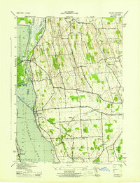 1943 Cayuga1943 Print · USGSThe northern reaches of Cayuga Lake and the Montezuma wetlands are captured here during the early 1940s. Genealogists can locate family-named landmarks like Farnam Cem and Polk Corners, alongside the tracks of the New York Central Railroad.
 - 1943 Map of Romulus
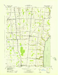 1943 Romulus1943 Print · USGSSeneca County's lakefront and agricultural heartland are captured during the Second World War as military and civilian life intersected. Researchers can trace family-named crossroads like Clemsons Corners, visit numerous district schools, and locate historic burials at Oak Hill Cem or Greenlawn Cem.
 - 1943 Map of Union Springs
 1943 Union Springs1943 Print · USGSThe eastern shores of Cayuga Lake come to life in the 1940s as the rail-and-water economy supports bustling lakeside villages. Genealogists can locate family landmarks from Red Jacket Cem to Sherwood, alongside numerous rural schools and the Lehigh Valley line.
 - 1943 Map of Seneca Falls, 1954 Print
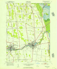 1943 Seneca Falls1954 Print · USGSSeneca Falls and Waterloo thrive at the crossroads of the New York canal and rail systems during the 1940s. Genealogists and historians can trace local school districts and family landmarks like Fox Cem, the Fairgrounds, and Dutch Cem.2 unique versions available
End of results
Showing maps 1-6 of 6
Top cities near Fayette
- Arcadia historical maps
- Geneva historical maps
- Seneca Falls historical maps
- Newark historical maps
- Waterloo historical maps
- Seneca Falls historical maps
See more
Top neighborhoods of Fayette
- Rose Hill historical maps
- Teall Beach historical maps
- Yale historical maps
- Canoga Springs historical maps
- Kuneytown historical maps
- Pastime Park historical maps
See more
Frequently asked questions
- What are the different types of historical maps available for Fayette?
- What is the oldest map of Fayette?
- Where can I purchase historical maps of Fayette for my home or office?
- Where can I download high-res historical maps of Fayette?
- Are there historical topographic maps available for Fayette?
- Is there historical aerial imagery available for Fayette?
- Where are historical maps of Fayette sourced from?