Old Maps of Yale, Fayette for Academic Research
Study the evolution of Yale with 13 high-resolution historic maps. Whether you're teaching, researching, or modeling changes in land use, these maps provide essential visual documentation of urban, environmental, and geographic change.
- Analyze long-term change: Track patterns in development, transportation, and natural features.
- Ideal for environmental or urban studies: Support academic projects with primary historical map data.
- Use in the classroom or lab: Educators and researchers rely on these maps to bring historical context to life.
These maps are a powerful tool for teaching, research, and visualizing how Yale has changed over the decades.
Yale, Fayette maps
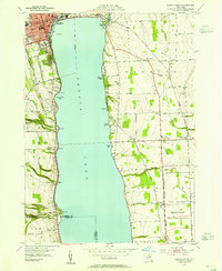
(13)- 1902 Map of Geneva
 1902 Geneva1902 Print · USGSThe Finger Lakes region at the dawn of the twentieth century was a bustling corridor of canals and competing railroads. Trace the intricate Steamboat Route on Seneca Lake and locate old stations like Billsboro Sta. and Reeder.7 unique versions available
 - 1943 Map of Geneva South
 1943 Geneva South1943 Print · USGSGeneva and the shores of Seneca Lake are captured here during the early 1940s, highlighting the region's academic and maritime identity. Researchers can trace the footprints of Hobart College, find local family names along Snell Road, or locate rail stops like Billsboro Sta.
 - 1950 Map of Elmira
 1950 Elmira1950 Print · USGSThe Finger Lakes region thrived in the late 1940s as a hub of industry and transport. Trace family roots and vanished landmarks near Seneca Lake or explore the rail lines of the Erie RR and the sprawling Seneca Ordnance Depot.2 unique versions available
 - 1953 Map of Geneva South, 1955 Print
 1953 Geneva South1955 Print · USGSSeneca Lake and its surrounding Finger Lakes communities are shown here in the early fifties, caught between institutional growth and military expansion. Researchers can trace local lineage through Bachman Cem or map the boundaries of the Seneca Ordnance Depot and the Colleges of the Seneca.5 unique versions available
 - 1958 Map of Elmira
 1958 Elmira1958 Print · USGSThe New York Finger Lakes during the late fifties reveal a complex landscape of glacial geology and industrial growth. Researchers can trace historic transport corridors like the Erie Canal and Erie RR, or locate institutional landmarks like Cornell University.2 unique versions available
 - 1962 Map of Elmira, 1969 Print
 1962 Elmira1969 Print · USGSThe Finger Lakes region and Southern Tier are captured here during a period of industrial maturity and highway expansion. Researchers can trace the path of the Erie Canal, the footprint of the Seneca Army Depot, and legacy rail lines through Elmira and Ithaca.4 unique versions available
 - 1965 Map of Elmira
 1965 Elmira1965 Print · USGSThe Finger Lakes and Southern Tier regions are captured in the mid-sixties, showcasing a landscape of deep glacial valleys and heavy rail infrastructure. Trace old railroad corridors like the Pennsylvania RR or visit landmarks like Letchworth State Park and the Seneca Army Depot.
 - 1986 Map of Auburn
 1986 Auburn1986 Print · USGSThe Finger Lakes region in the mid-eighties shows a landscape of deep glacial waters and significant military sites. Trace the layout of the Seneca Army Depot, find the campus of Wells College, and follow the historic Lehigh Valley RR lines.2 unique versions available
 - 2010 Map of Geneva South, 2010 Print
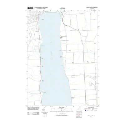 2010 Geneva South2010 Print · USGSCovers Yale, including Geneva, Waterloo, and other nearby areas
 - 2013 Map of Geneva South, 2013 Print
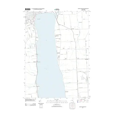 2013 Geneva South2013 Print · USGSCovers Yale, including Geneva, Waterloo, and other nearby areas
 - 2016 Map of Geneva South, 2016 Print
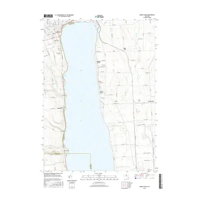 2016 Geneva South2016 Print · USGSCovers Yale, including Geneva, Waterloo, and other nearby areas
 - 2019 Map of Geneva South, 2019 Print
 2019 Geneva South2019 Print · USGSCovers Yale, including Geneva, Waterloo, and other nearby areas
 - 2023 Map of Geneva South, 2023 Print
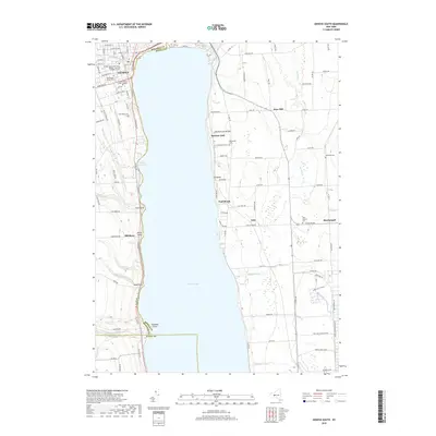
 2023 Geneva South2023 Print · USGSThe Finger Lakes shoreline near Geneva is captured here during the 2020s, showing the intersection of lakefront life and institutional history. Researchers can locate the Seneca Army Depot, Hobart & William Smith Colleges, and several rural burial grounds like Willowdale Cem.
End of results
Showing maps 1-13 of 13
Top cities near Yale
- Arcadia historical maps
- Geneva historical maps
- Manchester historical maps
- Seneca Falls historical maps
- Newark historical maps
- Waterloo historical maps
See more
Frequently asked questions
- What are the different types of historical maps available for Yale?
- What is the oldest map of Yale?
- Where can I purchase historical maps of Yale for my home or office?
- Where can I download high-res historical maps of Yale?
- Are there historical topographic maps available for Yale?
- Is there historical aerial imagery available for Yale?
- Where are historical maps of Yale sourced from?