1940s Maps of Tyre, New York
Explore 4 historic maps of Tyre from the 1940s. These maps offer a rare glimpse into what life looked like during the 1940s — showing old roads, neighborhoods, homes, and landmarks that have changed or disappeared over time.
Whether you're researching your family's past, planning a metal detecting trip, or studying how Tyre's landscape evolved across the 1940s, these high-resolution maps are a powerful tool for exploring the history of this region.
- Focus on a specific era: All maps on this page are from the 1940s, giving you a focused view of this time period.
- See what’s changed: Compare century-old streets, trails, and buildings to today's modern landscape using overlays and satellite layers.
- Research with precision: Use these maps for genealogy, historical research, land use analysis, or educational projects.
- View, download, or print: Maps are fully viewable online in high resolution, and can be downloaded or printed for your own records.
Start exploring Tyre's history through authentic maps from the 1940s. This is your window into the past.
Tyre, NY maps
(4)- 1943 Map of Montezuma
 1943 Montezuma1943 Print · USGSThe Cayuga County marshlands are captured here during the Second World War as the region’s massive river and canal systems were being managed for conservation. You can trace the early path of the Erie Canal (Abandoned) or find family sites near Port Byron and Murray Cem.
 - 1943 Map of Cayuga
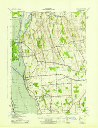 1943 Cayuga1943 Print · USGSThe northern reaches of Cayuga Lake and the Montezuma wetlands are captured here during the early 1940s. Genealogists can locate family-named landmarks like Farnam Cem and Polk Corners, alongside the tracks of the New York Central Railroad.
 - 1943 Map of Savannah
 1943 Savannah1943 Print · USGSThe marshlands and waterways of Wayne County are captured here in the 1940s, highlighting the vital corridor of the Erie Canal and Clyde River. Family historians can trace old homesteads near Hunt Corners, Lockpit Cem, and several numbered schoolhouses.
 - 1943 Map of Seneca Falls, 1954 Print
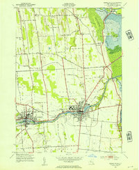 1943 Seneca Falls1954 Print · USGSSeneca Falls and Waterloo thrive at the crossroads of the New York canal and rail systems during the 1940s. Genealogists and historians can trace local school districts and family landmarks like Fox Cem, the Fairgrounds, and Dutch Cem.2 unique versions available
End of results
Showing maps 1-4 of 4
Top cities near Tyre
- Auburn historical maps
- Geneva historical maps
- Seneca Falls historical maps
- Sodus historical maps
- Waterloo historical maps
- Seneca Falls historical maps
See more
Top neighborhoods of Tyre
Frequently asked questions
- What are the different types of historical maps available for Tyre?
- What is the oldest map of Tyre?
- Where can I purchase historical maps of Tyre for my home or office?
- Where can I download high-res historical maps of Tyre?
- Are there historical topographic maps available for Tyre?
- Is there historical aerial imagery available for Tyre?
- Where are historical maps of Tyre sourced from?