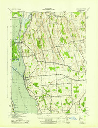
1943 Map of Cayuga
USGS Topo · Published 1943About this map
Cayuga Lake and the northern wetlands of the Montezuma Marsh dominate this 1943 landscape, reflecting a region defined by its historic water routes and early rail lines. The Cayuga and Seneca Canal cuts through the marshland, paralleled by the New York Central Railroad as it crosses the Seneca River near Free Bridge Corners. The map documents a rural network of numbered schoolhouses, including School No 7 and School No 5, which served scattered agrarian communities like Mentz Corners and Fosterville.
Find a feature on this map
50 named features on this map. Tap any name to fly to it.
Don’t see what you’re looking for? This feature index may not catch every label — zoom into the map to look around manually.
Map Details
Editions of this 1943 Cayuga Map
This is the sole edition of this map. No revisions or reprints were ever made.
Other maps of this area
1899 · Auburn
USGS Topo · 1:62,500
1902 · Geneva
USGS Topo · 1:62,500
1902 · Clyde
USGS Topo · 1:62,500
1902 · Weedsport
USGS Topo · 1:62,500
1902 · Auburn
USGS Topo · 1:62,500
1943 · Montezuma
USGS Topo · 1:31,680
1943 · Romulus
USGS Topo · 1:31,680
1943 · Scipio
USGS Topo · 1:31,680
1943 · Savannah
USGS Topo · 1:31,680
1943 · Weedsport
USGS Topo · 1:31,680