1960s Maps of Staten Island, New York
Explore 6 historic maps of Staten Island from the 1960s. These maps offer a rare glimpse into what life looked like during the 1960s — showing old roads, neighborhoods, homes, and landmarks that have changed or disappeared over time.
Whether you're researching your family's past, planning a metal detecting trip, or studying how Staten Island's landscape evolved across the 1960s, these high-resolution maps are a powerful tool for exploring the history of this region.
- Focus on a specific era: All maps on this page are from the 1960s, giving you a focused view of this time period.
- See what’s changed: Compare century-old streets, trails, and buildings to today's modern landscape using overlays and satellite layers.
- Research with precision: Use these maps for genealogy, historical research, land use analysis, or educational projects.
- View, download, or print: Maps are fully viewable online in high resolution, and can be downloaded or printed for your own records.
Start exploring Staten Island's history through authentic maps from the 1960s. This is your window into the past.
Staten Island, NY maps
(6)- 1960 Map of Newark
 1960 Newark1960 Print · USGSThe industrial heart of the Mid-Atlantic is shown at mid-century, stretching from the dense urban centers of Newark and Philadelphia to the Blue Mountain ridges. Researchers can trace historic rail lines, coastal defenses at Fort Hancock, and the riverfront growth of Trenton and Easton.3 unique versions available
 - 1964 Map of Newark
 1964 Newark1964 Print · USGSGreater New Jersey and eastern Pennsylvania appear at the peak of their industrial and rail-centered development in the mid-sixties. Genealogists and historians can trace the paths of the Pennsylvania RR, identify mid-century landmarks like CAMP KILMER, or follow the Schuylkill River through READING.2 unique versions available
 - 1966 Map of The Narrows, 1968 Print
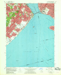 1966 The Narrows1968 Print · USGSThe mid-sixties saw Staten Island and Brooklyn transformed by the new bridge spanning The Narrows. Genealogists and historians can trace neighborhood growth through local landmarks like Moravian Cemetery, the Staten Island Transit line, and Fort Wadsworth.4 unique versions available
 - 1966 Map of Arthur Kill, 1969 Print
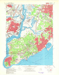 1966 Arthur Kill1969 Print · USGSStaten Island and the industrial shores of New Jersey are shown in the mid-sixties during a time of major suburban growth. Trace family roots and local landmarks through sites like the Willowbrook State School, The Richmondtown, and the Staten Island Rapid Transit line.4 unique versions available
 - 1967 Map of Jersey City, 1969 Print
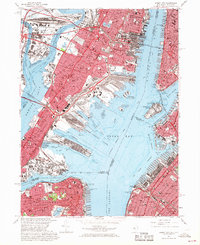 1967 Jersey City1969 Print · USGSThe industrial waterfront of Hudson County and Brooklyn is captured here in the late sixties. Researchers can trace the massive rail-to-sea networks of Meadows Yards and locate landmarks like Roosevelt Stadium and Ellis Island.3 unique versions available
 - 1967 Map of Elizabeth, 1969 Print
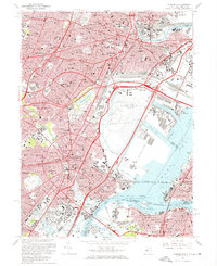 1967 Elizabeth1969 Print · USGSGreater Newark and Elizabeth are seen here at a mid-century peak of industrial and transit development. Researchers can trace historic parish boundaries and major landmarks like Seton Hall Univ, Evergreen Cemetery, and the Passaic River waterfront.3 unique versions available
End of results
Showing maps 1-6 of 6
Frequently asked questions
- What are the different types of historical maps available for Staten Island?
- What is the oldest map of Staten Island?
- Where can I purchase historical maps of Staten Island for my home or office?
- Where can I download high-res historical maps of Staten Island?
- Are there historical topographic maps available for Staten Island?
- Is there historical aerial imagery available for Staten Island?
- Where are historical maps of Staten Island sourced from?