1970s Maps of Steuben County, New York
Explore 3 historic maps of Steuben County from the 1970s. These maps offer a rare glimpse into what life looked like during the 1970s — showing old roads, neighborhoods, homes, and landmarks that have changed or disappeared over time.
Whether you're researching your family's past, planning a metal detecting trip, or studying how Steuben County's landscape evolved across the 1970s, these high-resolution maps are a powerful tool for exploring the history of this region.
- Focus on a specific era: All maps on this page are from the 1970s, giving you a focused view of this time period.
- See what’s changed: Compare century-old streets, trails, and buildings to today's modern landscape using overlays and satellite layers.
- Research with precision: Use these maps for genealogy, historical research, land use analysis, or educational projects.
- View, download, or print: Maps are fully viewable online in high resolution, and can be downloaded or printed for your own records.
Start exploring Steuben County's history through authentic maps from the 1970s. This is your window into the past.
Steuben County, NY maps
(3)- 1978 Map of Greenwood
 1978 Greenwood1978 Print · USGSSteuben County's ridges and hollows are detailed in this late 1970s survey as the local landscape balanced agriculture with a growing energy infrastructure. Researchers can locate remote burial grounds like Slaight Cem and trace the distribution of Oil Wells near West Greenwood.
 - 1978 Map of Hornell
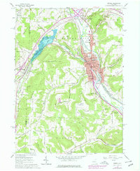 1978 Hornell1978 Print · USGSSteuben County was a bustling valley hub in the late seventies, defined by its rail corridor and the newly developed Almond Lake. Genealogists and local historians can trace family plots and parish life through St Marys Cemetery, Hartsville Church, and the Columbian School.
 - 1978 Map of Haskinville
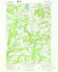 1978 Haskinville1978 Print · USGSSteuben County's upland farms and valley settlements are captured here in the late seventies. Family historians can trace rural property lines and landmarks like Beachville Cem, the Grange Hall in Greenville, and Jobs Corner.
End of results
Showing maps 1-3 of 3
Top cities of Steuben County
- Bath historical maps
- Corning historical maps
- Hornell historical maps
- Erwin historical maps
- Corning historical maps
- Hornellsville historical maps
See more
Frequently asked questions
- What are the different types of historical maps available for Steuben County?
- What is the oldest map of Steuben County?
- Where can I purchase historical maps of Steuben County for my home or office?
- Where can I download high-res historical maps of Steuben County?
- Are there historical topographic maps available for Steuben County?
- Is there historical aerial imagery available for Steuben County?
- Where are historical maps of Steuben County sourced from?