Old Maps of East Hampton, New York for Hiking & Exploration
Hike through history with 95 historic maps of East Hampton. Explore old trails, ghost towns, and forgotten backroads — perfect for outdoor adventurers and local explorers.
- Rediscover forgotten places: Map out old mining camps, roads, and footpaths that no longer exist on modern maps.
- Layer with modern tools: Combine with LiDAR or satellite views to plan hikes through historical terrain.
- Made for exploration: Popular among hikers, overlanders, and local history lovers.
Use these maps to find adventure and explore the hidden past of East Hampton.
East Hampton, NY maps
(95)- 1903 Map of Sag Harbor, 1961 Print
 1903 Sag Harbor1961 Print · USGSThe South Fork of Long Island at the start of the century reveals a coastal landscape of rail-linked hamlets and active life-saving stations. Researchers can trace the early layout of the Shinnecock Indian Reservation and locate historic stops like Wainscott Sta along the Long Island Railroad.
 - 1903 Map of Gardiners Island, 1962 Print
 1903 Gardiners Island1962 Print · USGSThe eastern reaches of Long Island and its surrounding sounds appear here at the opening of the twentieth century. Researchers can trace historic shorelines and maritime infrastructure, including Fort Terry on Plum Island and old settlements like Kingstown and Fireplace.
 - 1904 Map of Sag Harbor
 1904 Sag Harbor1904 Print · USGSThe South Fork of Long Island at the dawn of the 1900s reveals a maritime landscape of life-saving stations and rail-connected villages. Genealogists and historians can trace the early layout of Sag Harbor, the Montauk Division railroad stops, and the Shinnecock Indian Reservation.6 unique versions available
 - 1904 Map of Shelter Island
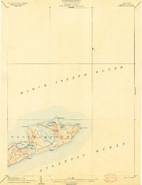
 1904 Shelter Island1904 Print · USGSEastern Long Island thrived at the dawn of the twentieth century as a premier maritime and rail destination. Trace the coastal growth of Sag Harbor and Greenport or locate family landmarks along the Long Island RR and at Orient Point.6 unique versions available
 - 1904 Map of Easthampton
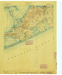
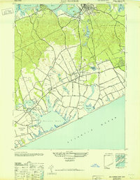
 1904 Easthampton1904 Print · USGSThe eastern reaches of Long Island at the turn of the century show a maritime landscape of small hamlets and life-saving stations. Genealogists and historians can trace the early rail corridor of the Long Island R. R. and locate family-named settlements like Freetown, Jericho, and Pantigo.6 unique versions available
 - 1904 Map of Gardiners Island
 1904 Gardiners Island1904 Print · USGSEasthampton and its outlying islands are captured here in the early twentieth century, showing a maritime landscape defined by coastal forts and small harbor landings. Genealogists and local historians can trace family-named sites like Barnes Landing, Springs, and the military outpost at Fort Terry.6 unique versions available
 - 1904 Map of Montauk
 1904 Montauk1904 Print · USGSThe tip of Long Island at the turn of the century is a maritime frontier where the railway meets the Atlantic. Researchers can trace the early layout of Montauk, the vital Montauk Point L.H., and coastal life-saving stations like Ditch Plain L.S.S.6 unique versions available
 - 1921 Map of Gardiners Island
 1921 Gardiners Island1921 Print · USGSThe maritime landscape of eastern Long Island is detailed here in the years following the Great War. Researchers can trace historic shorelines and landings like Quincetree Landing, locate the military grounds of Fort Terry, or find family-named sites such as Barnes Landing and Hicks.
 - 1921 Map of Easthampton
 1921 Easthampton1921 Print · USGSThe eastern tip of Long Island comes alive in the early twentieth century, showing a maritime landscape defined by rail and sea. Genealogy and history buffs can trace the Long Island R. R. through Easthampton or locate the coastal Georgica L.S.S. and the settlement at Promised Land.
 - 1942 Map of Montauk Point
 1942 Montauk Point1942 Print · USGSThe tip of Long Island comes into focus during the early 1940s as a vital coastal and maritime hub. Researchers can trace the Long Island railroad line to its terminus and locate specific landmarks like the Lighthouse and Ditch Plain LSS.
 - 1942 Map of Block Island, 1943 Print
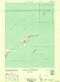
 1942 Block Island1943 Print · USGSThe coastal borderlands of Rhode Island and Connecticut are captured here during the wartime years, documenting a landscape defined by rail and sea. Researchers can trace the NY NH & H RR through historic mill villages or locate landmarks like the Silex Mine and Indian Burying Hill.2 unique versions available
 - 1943 Map of Gardiners Island East, 1947 Print
 1943 Gardiners Island East1947 Print · USGSGardiners Island and the East Hampton shoreline are captured here during the 1940s. Researchers can trace the Long Island Railroad corridor and explore old coastal landmarks like Quince Tree Landing, Cartwright Island, and Great Pond.
 - 1944 Map of Gardiners Island West, 1947 Print
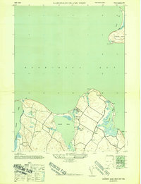 1944 Gardiners Island West1947 Print · USGSThe East Hampton shoreline during the 1940s reveals a quiet landscape of coastal hamlets and protected inlets. Genealogists and researchers can trace local routes through Springs and Eastside, or locate family landmarks like Powder Hill and Fireplace.2 unique versions available
 - 1946 Map of Sag Harbor
 1946 Sag Harbor1946 Print · USGSThe South Fork of Long Island at the end of the war years shows a landscape of coastal hamlets and large estates. Trace family names on rural lanes near Bridgehampton or locate early aviation landmarks like Hampton Airport and Easthampton Airport.
 - 1947 Map of Plum Island
 1947 Plum Island1947 Print · USGSCoastal Suffolk County is captured here just after the war, detailing the military footprint on the islands between the sounds. Researchers can trace the layout of Fort Terry and locate maritime landmarks like the Lighthouse and the Ferry Landing.2 unique versions available
 - 1947 Map of Greenport
 1947 Greenport1947 Print · USGSThe maritime communities of eastern Long Island are captured here in the late 1940s, highlighting the intricate coastal geography of the Peconic Bays. Historians can trace the streets of Greenport or locate specific waterfront landmarks near Sag Harbor and Shelter Island Heights.
 - 1947 Map of Napeague Beach
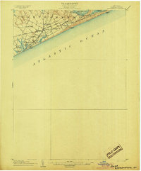
 1947 Napeague Beach1947 Print · USGSLong Island's eastern shoreline is documented here in the late 1940s, showing the intersection of coastal defense and rail travel. Historians can trace the Montauk Division railroad and find the Napeague CG Sta near Promised Land.
 - 1947 Map of East Hampton
 1947 East Hampton1947 Print · USGSThe South Fork of Long Island comes into focus just after the war as the coastal hamlets began their modern expansion. Trace the rail lines of the Long Island (Montauk Division) and find old landmarks like Hardscrabble, Pantigo, and Georgica Pond.
 - 1947 Map of Providence, 1948 Print
 1947 Providence1948 Print · USGSSouthern New England is captured in the mid-1940s, showing a landscape defined by busy industrial ports and expanding military installations. Researchers can trace the rail lines of the N.Y. N.H. & H. RR or locate coastal defenses like Fort Adams and Quonset Point.5 unique versions available
 - 1947 Map of Hartford, 1955 Print
 1947 Hartford1955 Print · USGSSouthern New England and the Hudson Valley are shown in detail during the post-war expansion era. Genealogists and researchers can trace local landmarks from the State Capitol and Yale University to the Stratford Lighthouse and Woodlawn Cem.2 unique versions available
 - 1948 Map of Hartford
 1948 Hartford1948 Print · USGSSouthern New England is captured here in the late 1940s, showcasing a landscape of thriving industrial cities and developing parkways. Genealogists and historians can trace the rail networks of the New York New Haven and Hartford RR or locate coastal defense sites like Fort Terry and Camp Shanks.2 unique versions available
 - 1948 Map of Providence, 1951 Print
 1948 Providence1951 Print · USGSSouthern New England’s coastal reaches are captured here in the late 1940s, from the industrial heart of Providence to the tip of Provincetown. Genealogists and historians can trace rail lines like the Central Vermont Railway and locate active military sites such as Otis Air Force Base and Fort Rodman.
 - 1949 Map of New York, 1951 Print
 1949 New York1951 Print · USGSLong Island and its surrounding waters are documented here in the late 1940s, just as the postwar suburban boom began to transform the region. Genealogists and historians can trace the early layouts of Idlewild Airport, Mitchell Field, and the established routes of the Long Island RR.
 - 1954 Map of New York
 1954 New York1954 Print · USGSLong Island and the New York metropolitan area are shown during the height of post-war suburbanization. Genealogists and historians can trace the growth of Levittown, the infrastructure of the Long Island Rail Road, and landmarks like Mitchel Afb.2 unique versions available
 - 1954 Map of Plum Island, 1971 Print
 1954 Plum Island1971 Print · USGSCoastal Suffolk County is captured here in the mid-fifties, showing the isolated research facilities and navigation aids that define these waters. Trace the geography of the Plum Island Restricted animal disease lab, the Latham Cem, and Little Gull I.2 unique versions available
Showing maps 1-25 of 95
Top cities near East Hampton
- Southampton historical maps
- Groton historical maps
- New London historical maps
- Southold historical maps
- Waterford historical maps
- East Lyme historical maps
See more
Top neighborhoods of East Hampton
- Gardiners Island historical maps
- Springs historical maps
- East Hampton North historical maps
- Northwest Harbor historical maps
- Montauk historical maps
- Amagansett historical maps
See more
Frequently asked questions
- What are the different types of historical maps available for East Hampton?
- What is the oldest map of East Hampton?
- Where can I purchase historical maps of East Hampton for my home or office?
- Where can I download high-res historical maps of East Hampton?
- Are there historical topographic maps available for East Hampton?
- Is there historical aerial imagery available for East Hampton?
- Where are historical maps of East Hampton sourced from?