1900-1909 Maps of Southold, New York
Explore 8 historic maps of Southold from 1900-1909. These maps offer a rare glimpse into what life looked like during the 1900s — showing old roads, neighborhoods, homes, and landmarks that have changed or disappeared over time.
Whether you're researching your family's past, planning a metal detecting trip, or studying how Southold's landscape evolved across the 1900s, these high-resolution maps are a powerful tool for exploring the history of this region.
- Focus on a specific era: All maps on this page are from the 1900s, giving you a focused view of this time period.
- See what’s changed: Compare century-old streets, trails, and buildings to today's modern landscape using overlays and satellite layers.
- Research with precision: Use these maps for genealogy, historical research, land use analysis, or educational projects.
- View, download, or print: Maps are fully viewable online in high resolution, and can be downloaded or printed for your own records.
Start exploring Southold's history through authentic maps from the 1900s. This is your window into the past.
Southold, NY maps
(8)- 1903 Map of Sag Harbor, 1961 Print
 1903 Sag Harbor1961 Print · USGSThe South Fork of Long Island at the start of the century reveals a coastal landscape of rail-linked hamlets and active life-saving stations. Researchers can trace the early layout of the Shinnecock Indian Reservation and locate historic stops like Wainscott Sta along the Long Island Railroad.
 - 1903 Map of Gardiners Island, 1962 Print
 1903 Gardiners Island1962 Print · USGSThe eastern reaches of Long Island and its surrounding sounds appear here at the opening of the twentieth century. Researchers can trace historic shorelines and maritime infrastructure, including Fort Terry on Plum Island and old settlements like Kingstown and Fireplace.
 - 1903 Map of Riverhead, 1963 Print
 1903 Riverhead1963 Print · USGSThe forks of Long Island come alive in this early 1900s survey of the bustling rail and maritime corridor. Researchers can trace the Long Island Railroad through historic hamlets like Good Ground, Aquebogue, and the early shoreline of Shinnecock Bay.
 - 1904 Map of Sag Harbor
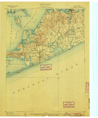 1904 Sag Harbor1904 Print · USGSThe South Fork of Long Island at the dawn of the 1900s reveals a maritime landscape of life-saving stations and rail-connected villages. Genealogists and historians can trace the early layout of Sag Harbor, the Montauk Division railroad stops, and the Shinnecock Indian Reservation.6 unique versions available
 - 1904 Map of Shelter Island
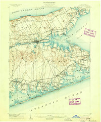
 1904 Shelter Island1904 Print · USGSEastern Long Island thrived at the dawn of the twentieth century as a premier maritime and rail destination. Trace the coastal growth of Sag Harbor and Greenport or locate family landmarks along the Long Island RR and at Orient Point.6 unique versions available
 - 1904 Map of Gardiners Island
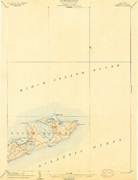
 1904 Gardiners Island1904 Print · USGSEasthampton and its outlying islands are captured here in the early twentieth century, showing a maritime landscape defined by coastal forts and small harbor landings. Genealogists and local historians can trace family-named sites like Barnes Landing, Springs, and the military outpost at Fort Terry.6 unique versions available
 - 1904 Map of Riverhead
 1904 Riverhead1904 Print · USGSEastern Long Island at the turn of the century shows a landscape of rail-connected hamlets and coastal vigilance. Researchers can trace the early layout of Riverhead or locate historic life-saving outposts like Tiana L.S.S. and Potunk L.S.S. along the barrier beaches.9 unique versions available
 - 1904 Map of Montauk
 1904 Montauk1904 Print · USGSThe tip of Long Island at the turn of the century is a maritime frontier where the railway meets the Atlantic. Researchers can trace the early layout of Montauk, the vital Montauk Point L.H., and coastal life-saving stations like Ditch Plain L.S.S.6 unique versions available
End of results
Showing maps 1-8 of 8
Top cities near Southold
- Southampton historical maps
- Groton historical maps
- East Hampton historical maps
- New London historical maps
- Waterford historical maps
- East Lyme historical maps
See more
Top neighborhoods of Southold
- Southold historical maps
- Mattituck historical maps
- Cutchogue historical maps
- Greenport historical maps
- Greenport West historical maps
- Laurel historical maps
See more
Frequently asked questions
- What are the different types of historical maps available for Southold?
- What is the oldest map of Southold?
- Where can I purchase historical maps of Southold for my home or office?
- Where can I download high-res historical maps of Southold?
- Are there historical topographic maps available for Southold?
- Is there historical aerial imagery available for Southold?
- Where are historical maps of Southold sourced from?