1930s Maps of Southold, New York
Explore 3 historic maps of Southold from the 1930s. These maps offer a rare glimpse into what life looked like during the 1930s — showing old roads, neighborhoods, homes, and landmarks that have changed or disappeared over time.
Whether you're researching your family's past, planning a metal detecting trip, or studying how Southold's landscape evolved across the 1930s, these high-resolution maps are a powerful tool for exploring the history of this region.
- Focus on a specific era: All maps on this page are from the 1930s, giving you a focused view of this time period.
- See what’s changed: Compare century-old streets, trails, and buildings to today's modern landscape using overlays and satellite layers.
- Research with precision: Use these maps for genealogy, historical research, land use analysis, or educational projects.
- View, download, or print: Maps are fully viewable online in high resolution, and can be downloaded or printed for your own records.
Start exploring Southold's history through authentic maps from the 1930s. This is your window into the past.
Southold, NY maps
(3)- 1934 Map of Niantic
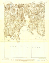 1934 Niantic1934 Print · USGSCoastal Connecticut in the 1930s reveals a landscape of growing beach colonies and significant state institutions. Genealogists and historians can trace family roots through Flanders Cem, or locate landmarks like the Seaside Connecticut State Sanatorium and the New York New Haven and Hartford Railroad.
 - 1938 Map of New London
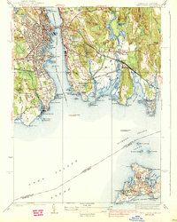 1938 New London1938 Print · USGSThe Thames River waterfront and Fishers Island are shown in detail during the late 1930s. Researchers can trace military and maritime history at Fort Trumbull and Fort H G Wright, or locate family sites like Bethel Cem and Fishtown Chapel.3 unique versions available
 - 1938 Map of Niantic
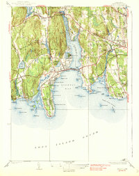 1938 Niantic1938 Print · USGSNiantic and East Lyme are captured here in the mid-1930s as the Connecticut shoreline evolved into a premier summer destination. Genealogists can locate family sites at Jordan Cem or St Marys Cem, while tracing the old Boston Post Road.3 unique versions available
End of results
Showing maps 1-3 of 3
Top cities near Southold
- Southampton historical maps
- Groton historical maps
- East Hampton historical maps
- New London historical maps
- Waterford historical maps
- East Lyme historical maps
See more
Top neighborhoods of Southold
- Southold historical maps
- Mattituck historical maps
- Cutchogue historical maps
- Greenport historical maps
- Greenport West historical maps
- Laurel historical maps
See more
Frequently asked questions
- What are the different types of historical maps available for Southold?
- What is the oldest map of Southold?
- Where can I purchase historical maps of Southold for my home or office?
- Where can I download high-res historical maps of Southold?
- Are there historical topographic maps available for Southold?
- Is there historical aerial imagery available for Southold?
- Where are historical maps of Southold sourced from?