1960s Maps of Candor, New York
Explore 7 historic maps of Candor from the 1960s. These maps offer a rare glimpse into what life looked like during the 1960s — showing old roads, neighborhoods, homes, and landmarks that have changed or disappeared over time.
Whether you're researching your family's past, planning a metal detecting trip, or studying how Candor's landscape evolved across the 1960s, these high-resolution maps are a powerful tool for exploring the history of this region.
- Focus on a specific era: All maps on this page are from the 1960s, giving you a focused view of this time period.
- See what’s changed: Compare century-old streets, trails, and buildings to today's modern landscape using overlays and satellite layers.
- Research with precision: Use these maps for genealogy, historical research, land use analysis, or educational projects.
- View, download, or print: Maps are fully viewable online in high resolution, and can be downloaded or printed for your own records.
Start exploring Candor's history through authentic maps from the 1960s. This is your window into the past.
Candor, NY maps
(7)- 1962 Map of Elmira, 1969 Print
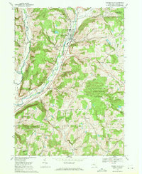
 1962 Elmira1969 Print · USGSThe Finger Lakes region and Southern Tier are captured here during a period of industrial maturity and highway expansion. Researchers can trace the path of the Erie Canal, the footprint of the Seneca Army Depot, and legacy rail lines through Elmira and Ithaca.4 unique versions available
 - 1965 Map of Elmira
 1965 Elmira1965 Print · USGSThe Finger Lakes and Southern Tier regions are captured in the mid-sixties, showcasing a landscape of deep glacial valleys and heavy rail infrastructure. Trace old railroad corridors like the Pennsylvania RR or visit landmarks like Letchworth State Park and the Seneca Army Depot.
 - 1969 Map of Speedsville, 1971 Print
 1969 Speedsville1971 Print · USGSThe hills of Tompkins and Tioga Counties are shown here during the late 1960s, a landscape defined by state forestry and small valley settlements. Trace local history through the streets of Speedsville or find landmarks like the Padlock Lookout Tower and St Marys Ch.2 unique versions available
 - 1969 Map of Newark Valley, 1971 Print
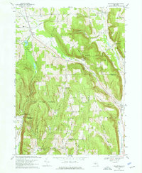
 1969 Newark Valley1971 Print · USGSTioga County's river valleys and forested ridges are captured here in the late sixties, centered on the village of Newark Valley. Genealogists and historians can trace the Lehigh Valley rail line and locate community landmarks like St Johns Ch and Pleasant Valley Cem.3 unique versions available
 - 1969 Map of Willseyville, 1971 Print
 1969 Willseyville1971 Print · USGSThe hills of southern Tompkins County come into focus in the late sixties as the high ridges of the Danby State Forest tower over rural valleys. Genealogists can trace family footprints at the Danby Rural Cem and Lane Cem, or locate the old White Church and Caroline Depot.4 unique versions available
 - 1969 Map of Candor, 1971 Print
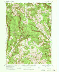
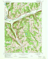
 1969 Candor1971 Print · USGSTioga County's creek valleys and ridgelines are captured here in the late sixties, showcasing the transit corridor between Candor and Flemingville. Genealogists can trace family landmarks and rural homesteads along Honey Pot Road or near the Evergreen Cem and Hubbardtown.
 - 1969 Map of Spencer, 1971 Print
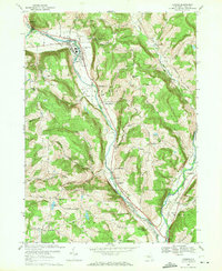
 1969 Spencer1971 Print · USGSTioga County is captured here in the late sixties as a landscape of valley settlements and steep ridges. Researchers can locate family landmarks like Baptist Corners Cem, the village of Spencer, and the rural crossroads at Halsey Valley.3 unique versions available
End of results
Showing maps 1-7 of 7
Top cities near Candor
- Union historical maps
- Ithaca historical maps
- Vestal historical maps
- Ithaca historical maps
- Owego historical maps
- Dryden historical maps
See more
Top neighborhoods of Candor
- Catatonk historical maps
- Gridleyville historical maps
- Hubbardtown historical maps
- Willseyville historical maps
- Weltonville historical maps
- Upper Fairfield historical maps
See more
Frequently asked questions
- What are the different types of historical maps available for Candor?
- What is the oldest map of Candor?
- Where can I purchase historical maps of Candor for my home or office?
- Where can I download high-res historical maps of Candor?
- Are there historical topographic maps available for Candor?
- Is there historical aerial imagery available for Candor?
- Where are historical maps of Candor sourced from?