Old Maps of Caroline, New York for Academic Research
Study the evolution of Caroline with 47 high-resolution historic maps. Whether you're teaching, researching, or modeling changes in land use, these maps provide essential visual documentation of urban, environmental, and geographic change.
- Analyze long-term change: Track patterns in development, transportation, and natural features.
- Ideal for environmental or urban studies: Support academic projects with primary historical map data.
- Use in the classroom or lab: Educators and researchers rely on these maps to bring historical context to life.
These maps are a powerful tool for teaching, research, and visualizing how Caroline has changed over the decades.
Caroline, NY maps
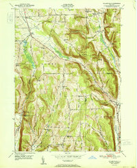
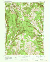
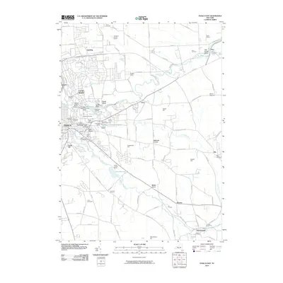
(47)- 1900 Map of Dryden
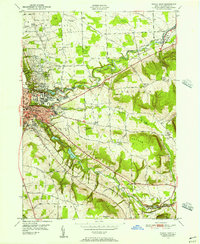
 1900 Dryden1900 Print · USGSThe Finger Lakes region comes to life in the late nineteenth century as the rail networks of the Lehigh Valley RR and the CAYUGA DIVISION expand through the valleys. Genealogists can trace family roots through the hill settlements of Caroline Center, South Danby, and the early grounds of Cornell University.9 unique versions available
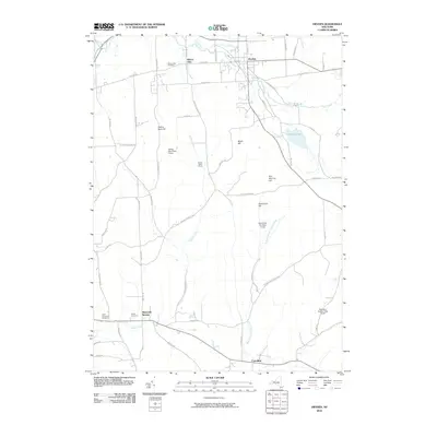
 - 1903 Map of Harford
 1903 Harford1903 Print · USGSThe Southern Tier of New York at the turn of the century reveals a landscape defined by deep valleys and the competing paths of the Lehigh Valley and Lackawanna railroads. Genealogists can trace early homesteads and hamlets like Harford Mills, Nanticoke, and Hunts Corners.5 unique versions available
 - 1906 Map of Catatonk
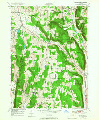
 1906 Catatonk1906 Print · USGSThe Southern Tier and Finger Lakes foothills are shown here at the peak of the rail era, before the expansion of modern highways. Genealogists can locate family lands near Slaterville Springs, trace the Lehigh Valley RR, or find early sites like White Church.
 - 1949 Map of Ithaca East, 1956 Print
 1949 Ithaca East1956 Print · USGSThe area surrounding Ithaca in the late 1940s shows the growth of Cornell University alongside long-established farming communities. Genealogists can trace family lines through sites like Brooktondale, Ellis Hollow Cem, and the Catskill Turnpike.2 unique versions available
 - 1949 Map of Willseyville, 1958 Print
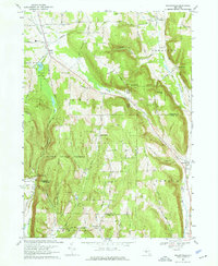
 1949 Willseyville1958 Print · USGSSouthern Tompkins County in the late 1940s shows a landscape of upland ridges and deep valley rail corridors. Genealogists and historians can trace family locations near Danby Rural Cem, early schoolhouses like Belle Sch, and the rail junction at Willseyville.2 unique versions available
 - 1949 Map of Dryden, 1962 Print
 1949 Dryden1962 Print · USGSTompkins County villages and highland farms are captured here in the late 1940s just as post-war changes began. Researchers can trace the Lehigh Valley Railroad through Dryden or locate family plots at Willow Glen Cem and Mulks Cem.
 - 1949 Map of Speedsville, 1966 Print
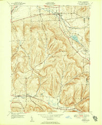
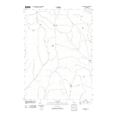
 1949 Speedsville1966 Print · USGSThe Tompkins and Tioga county line in the late 1940s was a landscape of high ridges and deep hollows centered on the village of Speedsville. Genealogists and historians can trace family locations along the Catskill Turnpike or find sites like School No 6 and the Padlock Lookout Tower.
 - 1950 Map of Elmira
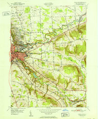
 1950 Elmira1950 Print · USGSThe Finger Lakes region thrived in the late 1940s as a hub of industry and transport. Trace family roots and vanished landmarks near Seneca Lake or explore the rail lines of the Erie RR and the sprawling Seneca Ordnance Depot.2 unique versions available
 - 1950 Map of Richford, 1952 Print
 1950 Richford1952 Print · USGSTioga County's rural valleys and high ridges are captured here in the early fifties, as the Lehigh Valley railroad still defined local commerce. Genealogists can trace family holdings near Evergreen Cem, Highland Chapel, and the hamlet of East Richford.4 unique versions available
 - 1951 Map of Willseyville
 1951 Willseyville1951 Print · USGSThe rural borderlands of Tompkins and Tioga counties are captured here in the mid-century, where rail lines and narrow valleys dictated the local economy. Genealogists and historians can trace family-named sites like Danby Rural Cemetery, South Danby, and Crum Town.
 - 1951 Map of Ithaca East
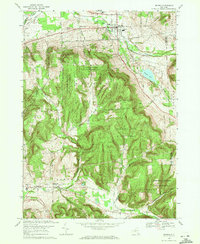
 1951 Ithaca East1951 Print · USGSIthaca and the surrounding Tompkins County highlands are documented here during the early fifties, showing the university campus and its neighboring hamlets. Genealogists can trace family names at East Lawn Cemetery or follow the rail lines of the Lehigh Valley.
 - 1951 Map of Dryden
 1951 Dryden1951 Print · USGSTompkins County hills and valleys are captured here in the early fifties, showing the area as a vital rail and road junction. Researchers can trace family roots through the Dutch Reformed Cem and follow the old Catskill Turnpike through Slaterville Springs.2 unique versions available
 - 1951 Map of Speedsville
 1951 Speedsville1951 Print · USGSThe Tompkins and Tioga county lines meet in this early 1950s survey of the hill country south of Ithaca. Researchers can trace historic travel routes like the Catskill Turnpike or locate rural landmarks including St Marys Ch, Padlock Lookout Tower, and School No 6.
 - 1958 Map of Elmira
 1958 Elmira1958 Print · USGSThe New York Finger Lakes during the late fifties reveal a complex landscape of glacial geology and industrial growth. Researchers can trace historic transport corridors like the Erie Canal and Erie RR, or locate institutional landmarks like Cornell University.2 unique versions available
 - 1962 Map of Elmira, 1969 Print
 1962 Elmira1969 Print · USGSThe Finger Lakes region and Southern Tier are captured here during a period of industrial maturity and highway expansion. Researchers can trace the path of the Erie Canal, the footprint of the Seneca Army Depot, and legacy rail lines through Elmira and Ithaca.4 unique versions available
 - 1965 Map of Elmira
 1965 Elmira1965 Print · USGSThe Finger Lakes and Southern Tier regions are captured in the mid-sixties, showcasing a landscape of deep glacial valleys and heavy rail infrastructure. Trace old railroad corridors like the Pennsylvania RR or visit landmarks like Letchworth State Park and the Seneca Army Depot.
 - 1969 Map of Speedsville, 1971 Print
 1969 Speedsville1971 Print · USGSThe hills of Tompkins and Tioga Counties are shown here during the late 1960s, a landscape defined by state forestry and small valley settlements. Trace local history through the streets of Speedsville or find landmarks like the Padlock Lookout Tower and St Marys Ch.2 unique versions available
 - 1969 Map of Willseyville, 1971 Print
 1969 Willseyville1971 Print · USGSThe hills of southern Tompkins County come into focus in the late sixties as the high ridges of the Danby State Forest tower over rural valleys. Genealogists can trace family footprints at the Danby Rural Cem and Lane Cem, or locate the old White Church and Caroline Depot.4 unique versions available
 - 1969 Map of Dryden, 1971 Print
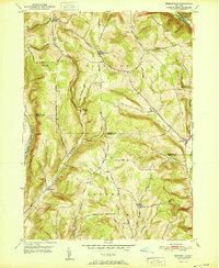
 1969 Dryden1971 Print · USGSDryden and the southern hills of Tompkins County are seen here in the late sixties, a landscape where valley railroads met sprawling state forests. Genealogists and local historians can locate several historic burial sites like Mulks Cem and old schools including the Caroline Sch and Central Sch.3 unique versions available
 - 1969 Map of Ithaca East, 1972 Print
 1969 Ithaca East1972 Print · USGSIthaca and the surrounding Tompkins County highlands reached a peak of academic and infrastructure growth in the late sixties. Genealogists and historians can trace the foundations of Cornell University, the Lehigh Valley rail route, and old burial grounds like East Lawn Cemetery.3 unique versions available
 - 1986 Map of Elmira
 1986 Elmira1986 Print · USGSThe Southern Tier and Finger Lakes regions meet in this mid-eighties survey of the river valleys and high ridges. Genealogists can trace family names at Forest Lawn Memorial Park or locate homesteads near Breesport and Newark Valley.
 - 1992 Map of Elmira, 1993 Print
 1992 Elmira1993 Print · USGSThe Finger Lakes and Southern Tier regions are captured in the early nineties as industrial hubs like Elmira and Endicott thrived alongside university life in Ithaca. Genealogists and researchers can trace the CONRAIL rail corridors, family hilltops such as Hornby Hill, and the extensive Newtown Battlefield Reservation.
 - 2010 Map of Speedsville, 2010 Print
 2010 Speedsville2010 Print · USGSCovers Caroline, including Candor, Berkshire, and other nearby areas
 - 2010 Map of Dryden, 2010 Print
 2010 Dryden2010 Print · USGSCovers Caroline, including Dryden, Virgil, and other nearby areas
 - 2010 Map of Ithaca East, 2010 Print
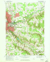
 2010 Ithaca East2010 Print · USGSCovers Caroline, including Ithaca, Ithaca, and other nearby areas
Showing maps 1-25 of 47
Top cities near Caroline
- Union historical maps
- Ithaca historical maps
- Ithaca historical maps
- Owego historical maps
- Dryden historical maps
- Lansing historical maps
See more
Top neighborhoods of Caroline
- Caroline Depot historical maps
- White Church historical maps
- Boiceville historical maps
- Speedsville historical maps
- Caroline Center historical maps
- West Slaterville historical maps
See more
Frequently asked questions
- What are the different types of historical maps available for Caroline?
- What is the oldest map of Caroline?
- Where can I purchase historical maps of Caroline for my home or office?
- Where can I download high-res historical maps of Caroline?
- Are there historical topographic maps available for Caroline?
- Is there historical aerial imagery available for Caroline?
- Where are historical maps of Caroline sourced from?