1940s Maps of Pine Hill, Shandaken
Explore 3 historic maps of Pine Hill from the 1940s. These maps offer a rare glimpse into what life looked like during the 1940s — showing old roads, neighborhoods, homes, and landmarks that have changed or disappeared over time.
Whether you're researching your family's past, planning a metal detecting trip, or studying how Pine Hill's landscape evolved across the 1940s, these high-resolution maps are a powerful tool for exploring the history of this region.
- Focus on a specific era: All maps on this page are from the 1940s, giving you a focused view of this time period.
- See what’s changed: Compare century-old streets, trails, and buildings to today's modern landscape using overlays and satellite layers.
- Research with precision: Use these maps for genealogy, historical research, land use analysis, or educational projects.
- View, download, or print: Maps are fully viewable online in high resolution, and can be downloaded or printed for your own records.
Start exploring Pine Hill's history through authentic maps from the 1940s. This is your window into the past.
Pine Hill, Shandaken maps
(3)- 1945 Map of West Kill, 1946 Print
 1945 West Kill1946 Print · USGSThe High Peaks region of the Catskills is captured here at the close of the 1940s, showing a landscape defined by deep valleys and timbered ridges. Genealogists can trace family names and sites like Halcott Cem, Bushnellsville, and several local schoolhouses including School No 2.
 - 1946 Map of Shandaken
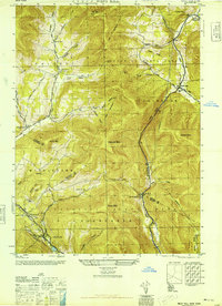
 1946 Shandaken1946 Print · USGSThe central Catskills in the mid-1940s were defined by a rail-and-river economy tightly constrained by some of the region's highest peaks. Genealogists and historians can trace the early infrastructure of Big Indian and Oliverea or locate rural landmarks like School No 4 and the Belleayr Lookout Tower.2 unique versions available
 - 1948 Map of Binghamton, 1980 Print
 1948 Binghamton1980 Print · USGSCentral New York and the Southern Tier thrive in the late 1940s as a hub of rail traffic and mountain industry. Researchers can trace historic transit lines like the Erie Railroad through Binghamton or find old valley settlements near Oneonta and Delhi.
End of results
Showing maps 1-3 of 3
Top cities near Pine Hill
- Rochester historical maps
- Woodstock historical maps
- Marbletown historical maps
- Olive historical maps
- Neversink historical maps
- Middletown historical maps
See more
Top neighborhoods of Pine Hill
Frequently asked questions
- What are the different types of historical maps available for Pine Hill?
- What is the oldest map of Pine Hill?
- Where can I purchase historical maps of Pine Hill for my home or office?
- Where can I download high-res historical maps of Pine Hill?
- Are there historical topographic maps available for Pine Hill?
- Is there historical aerial imagery available for Pine Hill?
- Where are historical maps of Pine Hill sourced from?