Old Maps of Shawangunk, New York for Genealogy
Trace your family roots with 61 historic maps of Shawangunk. These high-res maps reveal old neighborhoods, homesites, landmarks, and streets — helping you uncover where your ancestors lived and how the area evolved over time.
- Explore historic neighborhoods: Identify where your relatives may have lived in the 1800s or 1900s.
- Compare maps over time: Trace the changes in streets, buildings, and landmarks for multi-generational research.
- Perfect for genealogy & ancestry research: Used by family historians and researchers to map out lineage and migration.
These maps are an incredible resource for exploring your personal connection to Shawangunk's past.
Shawangunk, NY maps
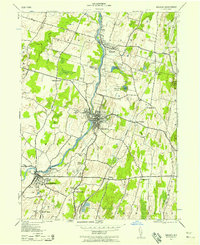
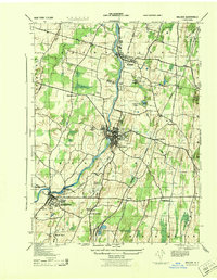
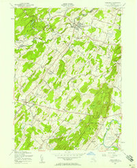
(61)- 1903 Map of Newburg
 1903 Newburg1903 Print · USGSThe Hudson Valley was entering a period of rapid industrial and rail expansion when this survey was conducted. Researchers can trace the path of the New England RR, find local landmarks like the Powder Works, and locate old hamlets such as Ganahgote and Leptondale.10 unique versions available
 - 1904 Map of Ellenville, 1956 Print
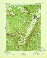
 1904 Ellenville1956 Print · USGSThe Shawangunk Mountains and Wallkill Valley are captured here at the start of the twentieth century, showing a landscape of high ridges and industrial valleys. Researchers can trace the D. & H. Canal (Abandoned), the New York Ontario and Western RR, and historic centers like Ellenville or Wurtsboro.
 - 1906 Map of Ellenville
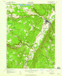
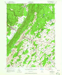
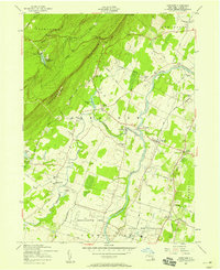
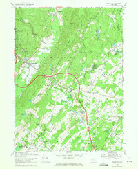
 1906 Ellenville1906 Print · USGSThe Shawangunk ridge and Mamakating Hollow are captured here in the early 1900s, showing the region's shift from canal to rail transport. Genealogists can locate family homes and landmarks across Ellenville, Cragsmoor, and Wurtsboro, or trace the Delaware and Hudson Canal.7 unique versions available
 - 1942 Map of Walden, 1958 Print
 1942 Walden1958 Print · USGSOrange County's Wallkill Valley at the height of the war era reveals a landscape of riverside industry and family-owned dairy farms. Genealogists and local historians can trace legacy sites like the Borden Estate, Montgomery Worsted Mills, and Goodwill Church.
 - 1942 Map of Ellenville, 1959 Print
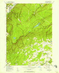
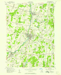
 1942 Ellenville1959 Print · USGSThe valleys surrounding Ellenville and the Shawangunk Mountains are seen here at a mid-century crossroads of transport history. Genealogists can locate family-named landmarks like Poplar Grove Cem and several rural schoolhouses, including Sandburg Rend Sch and Greenwood Sch.2 unique versions available
 - 1943 Map of Clintondale
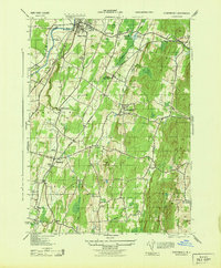 1943 Clintondale1943 Print · USGSMid-Hudson Valley farm country and orchards are shown here during the early years of the Second World War. Researchers can locate vanished landmarks such as the Normal Sch or trace early rail lines like the New York New Haven and Hartford.
 - 1943 Map of Gardiner
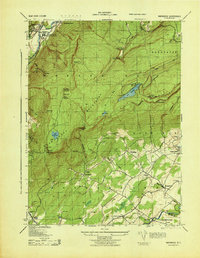
 1943 Gardiner1943 Print · USGSUlster County's mountain resorts and valley farms are captured here during the early war years. Researchers can trace the legacy of the Shawangunk ridge at Wildmere House or locate family roots at the Bruynswick Cemetery and Galeville School.
 - 1943 Map of Napanoch
 1943 Napanoch1943 Print · USGSThe Shawangunk Mountains and the valley of the Rondout Creek are captured here in the early 1940s. Genealogists and historians can trace family properties like V Mahon and H Hall or locate rural landmarks such as Crawford Church and the Union District School.
 - 1943 Map of Walden
 1943 Walden1943 Print · USGSOrange County's riverfront villages and dairy heritage are captured here in the early 1940s. Genealogists can locate family landmarks like the Borden Estate or St Marys Cemetery, while tracing the paths of the Wallkill Valley Branch railroad.
 - 1943 Map of Ellenville
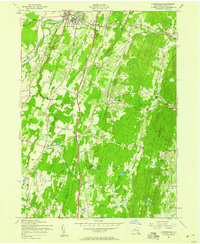
 1943 Ellenville1943 Print · USGSThe Shawangunk valley corridor during the war years shows a landscape defined by the Delaware and Hudson Canal and the O&W railroad. Trace local roots at Fantine Cemetery or find historic sites like the Pepsi Cola Bottling Co and Greenwood School.
 - 1943 Map of Pinebush, 1944 Print
 1943 Pinebush1944 Print · USGSThe rural borderlands of Orange and Ulster counties come alive in the 1940s, anchored by the rail hub at Pinebush. Genealogists can trace family homesteads like C. Judson and M. Durnin or locate landmarks like the Brimstone School and Hopewell Cemetery.
 - 1943 Map of Wurtsboro, 1954 Print
 1943 Wurtsboro1954 Print · USGSSullivan and Orange County hillsides were undergoing a transit transition during the early years of the war. Researchers can trace the legacy of the Delaware and Hudson Canal, find family names at Sylvan Cem, and locate rural landmarks like Prosperous Valley Sch.3 unique versions available
 - 1946 Map of Newburgh, 1964 Print
 1946 Newburgh1964 Print · USGSMid-Hudson Valley life in the mid-forties is captured here, showing the region as it transitioned from a rural agricultural economy to a postwar industrial hub. Genealogists and local historians can locate dozens of small schools and cemeteries, from the New Paltz Cemetery to the Montgomery Worsted Mills.
 - 1950 Map of Scranton, 1952 Print
 1950 Scranton1952 Print · USGSMid-century Northeast Pennsylvania and the Hudson Valley come alive in this survey of the tri-state region. Genealogists and historians can trace the dense rail networks of the Erie RR and DL&W RR between industrial hubs like Scranton and Wilkes-Barre.
 - 1953 Map of Scranton
 1953 Scranton1953 Print · USGSNortheastern Pennsylvania and the Catskills are shown in great detail during the early fifties, a time when rail lines and river valleys dictated the region's growth. Genealogists and historians can trace the industrial hearts of Scranton and Wilkes-Barre or locate remote landmarks like High Point and Lake Wallenpaupack.
 - 1956 Map of Napanoch, 1958 Print
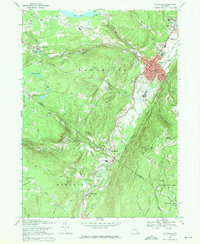
 1956 Napanoch1958 Print · USGSThe Shawangunk Mountains define the landscape of Ulster County in the mid-fifties, separating the industrial valley from upland summer camps. Researchers can trace the New York Ontario and Western rail line through Napanoch or locate landmarks like Red Mills and the State Institution for Male Defective Delinquents.4 unique versions available
 - 1956 Map of Pine Bush, 1958 Print
 1956 Pine Bush1958 Print · USGSIn the mid-1950s, this area of the Hudson Valley maintained a rural character defined by the Erie RR and small valley settlements. Researchers can trace family history through sites like Howell Cem, St Pauls Ch, and the hamlet of Ulsterville.3 unique versions available
 - 1957 Map of Gardiner, 1958 Print
 1957 Gardiner1958 Print · USGSUlster County's landscape in the late fifties is defined by the steep Shawangunk ridges and the winding river valleys of the Wallkill. Researchers can locate historic rural sites such as Bruynswick Cemetery, the Cliffhouse, and St Charles Ch.3 unique versions available
 - 1957 Map of Walden, 1958 Print
 1957 Walden1958 Print · USGSOrange County's mid-century river valley comes alive in this survey of the river-and-rail corridor between Walden and Montgomery. Genealogists can trace family sites at Wallkill Valley Cemetery and Goodwill Ch, or explore the massive Maybrook Yards rail infrastructure.2 unique versions available
 - 1957 Map of Clintondale, 1958 Print
 1957 Clintondale1958 Print · USGSMid-century Ulster County is captured here as the new thruway begins to reshape the rural landscape around New Paltz. Local researchers can trace the old rail lines of the New York New Haven and Hartford and locate family landmarks like Lloyd Union Cem or Modena Gardens.3 unique versions available
 - 1959 Map of Scranton
 1959 Scranton1959 Print · USGSThe northern coalfields and the Hudson Valley meet in this mid-century survey of the Pennsylvania and New York borderlands. Genealogists and historians can trace the intricate rail networks of the Erie Railroad and the vast waters of Lake Wallenpaupack.2 unique versions available
 - 1962 Map of Scranton, 1977 Print
 1962 Scranton1977 Print · USGSThe industrial heart of eastern Pennsylvania and the New York Catskills are captured here in the early sixties. Genealogists and historians can trace the dense valley settlements from Scranton to Wilkes-Barre and the rail lines of the Erie Lackawanna Railroad.2 unique versions available
 - 1965 Map of Scranton
 1965 Scranton1965 Print · USGSThe tri-state highlands of Pennsylvania, New York, and New Jersey come alive in the mid-sixties as industry and recreation converge. Trace the intricate rail lines of the Erie Lackawanna RR or locate landmarks like the U S Military Academy.2 unique versions available
 - 1969 Map of Wurtsboro, 1971 Print
 1969 Wurtsboro1971 Print · USGSSullivan and Orange County settlements are captured here in the late sixties, showing the alignment of the Shawangunk Mountains and the Basher Kill valley. Genealogists can locate family landmarks like Stanton Memorial Cem or the Chase Sch near Wurtsboro.3 unique versions available
 - 1969 Map of Ellenville, 1971 Print
 1969 Ellenville1971 Print · USGSEllenville and the surrounding Ulster County valley are shown at the height of the mid-century era. Genealogists and researchers can locate Poplar Grove Cemetery, the Church St School, and landmarks like the Municipal Building or Napanoch station.3 unique versions available
Showing maps 1-25 of 61
Top cities near Shawangunk
- Newburgh historical maps
- Wallkill historical maps
- Middletown historical maps
- Newburgh historical maps
- New Windsor historical maps
- Montgomery historical maps
See more
Top neighborhoods of Shawangunk
- Bruynswick historical maps
- Borden Estate historical maps
- Crawford historical maps
- Dwaarkill historical maps
- Red Mills historical maps
- Saint Elmo historical maps
See more
Frequently asked questions
- What are the different types of historical maps available for Shawangunk?
- What is the oldest map of Shawangunk?
- Where can I purchase historical maps of Shawangunk for my home or office?
- Where can I download high-res historical maps of Shawangunk?
- Are there historical topographic maps available for Shawangunk?
- Is there historical aerial imagery available for Shawangunk?
- Where are historical maps of Shawangunk sourced from?