Old Maps of Greenwich, New York for Genealogy
Trace your family roots with 28 historic maps of Greenwich. These high-res maps reveal old neighborhoods, homesites, landmarks, and streets — helping you uncover where your ancestors lived and how the area evolved over time.
- Explore historic neighborhoods: Identify where your relatives may have lived in the 1800s or 1900s.
- Compare maps over time: Trace the changes in streets, buildings, and landmarks for multi-generational research.
- Perfect for genealogy & ancestry research: Used by family historians and researchers to map out lineage and migration.
These maps are an incredible resource for exploring your personal connection to Greenwich's past.
Greenwich, NY maps
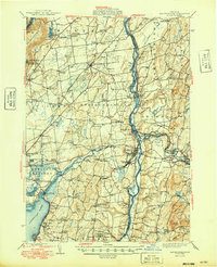
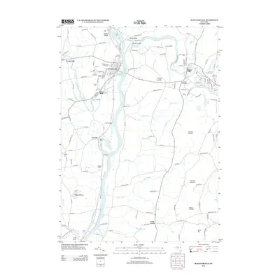
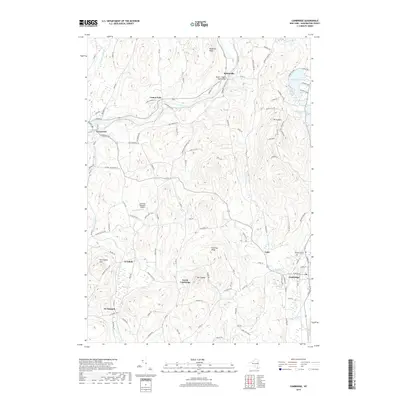
(28)- 1895 Map of Cambridge
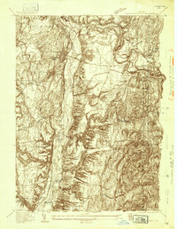
 1895 Cambridge1895 Print · USGSWashington County, New York, is captured in the 1890s as a landscape of interconnected rail lines and riverside villages. Genealogists and historians can trace the paths of the Rutland and Washington R.R. through Salem or locate family roots in hamlets like Pumpkin Hook and Shushan.
 - 1898 Map of Cambridge
 1898 Cambridge1898 Print · USGSWashington County at the close of the nineteenth century was a landscape of river-powered hamlets and busy rail corridors. Researchers can trace ancestral farmsteads and early industry near Batten Kill or explore the rail stops at Easton Sta. and Salem.
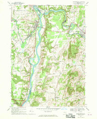
 - 1900 Map of Schuylerville
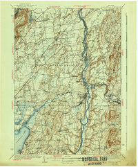
 1900 Schuylerville1900 Print · USGSUpper Hudson Valley life at the close of the nineteenth century centers on the busy canal and river corridor. Researchers can trace the Champlain Canal through Schuylerville and Fort Miller, or locate family sites near the Saratoga Battle Field and Gansevoort.7 unique versions available
 - 1901 Map of Cambridge
 1901 Cambridge1901 Print · USGSWashington County at the turn of the century is a landscape of river-powered industry and sprawling rail networks connecting New York to Vermont. Genealogists and historians can trace the paths of the Batten Kill, find old rail stops at Easton Sta., and locate vanished names like Pumpkin Hook.8 unique versions available
 - 1903 Map of Mettawee
 1903 Mettawee1903 Print · USGSThe New York and Vermont borderlands come alive in this turn-of-the-century survey of the Mettawee Valley. Genealogists can trace family footprints from Middletown Springs down to the Saratoga and Champlain Canal at Fort Ann.2 unique versions available
 - 1935 Map of Schuylerville
 1935 Schuylerville1935 Print · USGSThe Hudson River valley around Schuylerville and Greenwich is mapped here in the mid-1930s, showing the early evolution of the Saratoga region's industrial and historic landscape. Genealogists and historians can locate family landmarks like Rafferty Sch, the St Josephs Cem, and the now-quiet Champlain Canal (Abandoned).
 - 1940 Map of Schuylerville
 1940 Schuylerville1940 Print · USGSSaratoga and Washington Counties are shown here just before the mid-century, defined by the industrial river towns and the grounds of the Saratoga Battlefield. Genealogists can trace family names at Clarks Corners or Quaker Springs and locate early 20th-century landmarks like the Saratoga Battle Monument.3 unique versions available
 - 1944 Map of Cambridge, 1955 Print
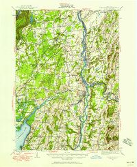
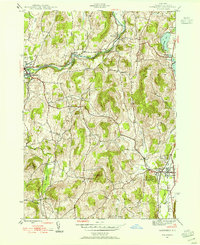 1944 Cambridge1955 Print · USGSMid-century Washington County reveals a landscape shaped by the Batten Kill and early rail corridors before the modern highway era. Researchers can trace historic property locations near Woodland Cem, rural schoolhouses like School No 1, and the rail lines of the Delaware and Hudson.3 unique versions available
 - 1946 Map of Cambridge
 1946 Cambridge1946 Print · USGSWashington County during the mid-forties reveals a landscape of river-valley rail towns and upland dairy farms. Genealogists and local historians can trace the foundations of Cambridge and Greenwich, locating specific landmarks like Woodland Cem and the Cary Sch.2 unique versions available
 - 1947 Map of Schuylerville, 1958 Print
 1947 Schuylerville1958 Print · USGSUpper Hudson Valley life and Revolutionary War heritage meet in the late 1940s. Trace the path of the Champlain Canal and find local landmarks like the Saratoga Battle Monument and the Fernwood Trout Hatchery.3 unique versions available
 - 1949 Map of Schuylerville
 1949 Schuylerville1949 Print · USGSUpper Hudson Valley life in the late nineteen-forties centers on the river and its canal, shortly after the national park was established. Genealogists and historians can trace family locations near Victory Mills, old rural burial grounds like Griswold Cem, and the Fernwood Trout Hatchery.
 - 1950 Map of Glens Falls
 1950 Glens Falls1950 Print · USGSThe Adirondacks and the Green Mountains meet in this mid-century survey of the New York and Vermont borderlands. Researchers can trace the industrial rail corridors of the Rutland RR and Delaware & Hudson RR connecting Glens Falls, Rutland, and the shores of Lake George.
 - 1956 Map of Glens Falls, 1968 Print
 1956 Glens Falls1968 Print · USGSUpper New York and the Vermont mountains are captured here in the mid-fifties, showing the rugged rail-and-river network of the Northeast. Researchers can trace the paths of the Delaware and Hudson RR and Rutland RR as they wind through valley towns like Poultney and Whitehall.3 unique versions available
 - 1959 Map of Glens Falls
 1959 Glens Falls1959 Print · USGSUpper New York and Vermont are captured here during the late 1950s, a period of transition for these mountain communities. Researchers can trace the legacy of the region's river-and-rail economy through landmarks like Lake George, Saratoga Springs, and Killington Peak.2 unique versions available
 - 1964 Map of Glens Falls
 1964 Glens Falls1964 Print · USGSThe tri-state borderlands of New York, Vermont, and New Hampshire appear here in the mid-1960s. Researchers can trace the rail routes of the Rutland RR and find historic sites like Ticonderoga and Saratoga National Historical Park.
 - 1967 Map of Schuylerville, 1970 Print
 1967 Schuylerville1970 Print · USGSThe Hudson River valley and the industrial corridor of the Batten Kill are captured here in the late sixties. Genealogists and local historians can trace family-named routes like Hanehan Rd and landmarks including Victory Mills and Starks Knob.
 - 1986 Map of Glens Falls
 1986 Glens Falls1986 Print · USGSThe Upper Hudson Valley and Vermont borderlands come together in this mid-eighties survey of industrial river towns and mountain retreats. Genealogists and historians can trace the rail lines of the Delaware and Hudson Railway or locate landmarks like the Mount McGregor Correctional Facility and Saratoga Spa State Park.2 unique versions available
 - 1989 Map of Glens Falls
 1989 Glens Falls1989 Print · USGSThe Upper Hudson Valley and the Vermont borderlands are captured here during the late eighties, showing a landscape of river-town industry and mountain recreation. Researchers can trace the Champlain Canal, the Delaware and Hudson RR, and historic sites like Saratoga National Historical Park.
 - 2010 Map of Cambridge, 2010 Print
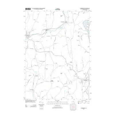
 2010 Cambridge2010 Print · USGSCovers Greenwich, including White Creek, Easton, and other nearby areas
 - 2010 Map of Schuylerville, 2010 Print
 2010 Schuylerville2010 Print · USGSCovers Greenwich, including Stillwater, Saratoga, and other nearby areas
 - 2013 Map of Schuylerville, 2013 Print
 2013 Schuylerville2013 Print · USGSCovers Greenwich, including Stillwater, Saratoga, and other nearby areas
 - 2013 Map of Cambridge, 2013 Print
 2013 Cambridge2013 Print · USGSCovers Greenwich, including White Creek, Easton, and other nearby areas
 - 2016 Map of Schuylerville, 2016 Print
 2016 Schuylerville2016 Print · USGSCovers Greenwich, including Stillwater, Saratoga, and other nearby areas
 - 2016 Map of Cambridge, 2016 Print
 2016 Cambridge2016 Print · USGSCovers Greenwich, including White Creek, Easton, and other nearby areas
 - 2019 Map of Cambridge, 2019 Print
 2019 Cambridge2019 Print · USGSCovers Greenwich, including White Creek, Easton, and other nearby areas
Showing maps 1-25 of 28
Top cities near Greenwich
- Queensbury historical maps
- Saratoga Springs historical maps
- Halfmoon historical maps
- Wilton historical maps
- Moreau historical maps
- Glens Falls historical maps
See more
Frequently asked questions
- What are the different types of historical maps available for Greenwich?
- What is the oldest map of Greenwich?
- Where can I purchase historical maps of Greenwich for my home or office?
- Where can I download high-res historical maps of Greenwich?
- Are there historical topographic maps available for Greenwich?
- Is there historical aerial imagery available for Greenwich?
- Where are historical maps of Greenwich sourced from?