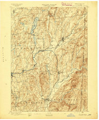
1895 Map of Cambridge
USGS Topo · Published 1895About this map
The Batten Kill winds through the heart of Washington County, serving as a corridor for settlement and industry in the late 19th century. This terrain is defined by its numerous small lakes and ponds, such as Cossayuna Lake and Lake Lauderdale, which are interspersed among named peaks like Hebron Mt. and Huckleberry Hill. The map illustrates a developed rail network, showing the Rutland and Washington R.R. and the Greenwich and Johnsonville R.R. as they connect village centers like Salem and Greenwich.
Find a feature on this map
76 named features on this map. Tap any name to fly to it.
Don’t see what you’re looking for? This feature index may not catch every label — zoom into the map to look around manually.
Map Details
Editions of this 1895 Cambridge Map
This is the sole edition of this map. No revisions or reprints were ever made.
Other maps of this area
1893 · Cohoes
USGS Topo · 1:62,500

1893 · Fort Ann
USGS Topo · 1:62,500

1894 · Pawlet
USGS Topo · 1:62,500
1894 · Equinox
USGS Topo · 1:62,500
1895 · Cohoes
USGS Topo · 1:62,500

1895 · Fort Ann
USGS Topo · 1:62,500
1895 · Glens Falls
USGS Topo · 1:62,500
1896 · Equinox
USGS Topo · 1:62,500
1897 · Pawlet
USGS Topo · 1:62,500
1897 · Glens Falls
USGS Topo · 1:62,500