1940s Maps of Low Hampton, Hampton
Explore 2 historic maps of Low Hampton from the 1940s. These maps offer a rare glimpse into what life looked like during the 1940s — showing old roads, neighborhoods, homes, and landmarks that have changed or disappeared over time.
Whether you're researching your family's past, planning a metal detecting trip, or studying how Low Hampton's landscape evolved across the 1940s, these high-resolution maps are a powerful tool for exploring the history of this region.
- Focus on a specific era: All maps on this page are from the 1940s, giving you a focused view of this time period.
- See what’s changed: Compare century-old streets, trails, and buildings to today's modern landscape using overlays and satellite layers.
- Research with precision: Use these maps for genealogy, historical research, land use analysis, or educational projects.
- View, download, or print: Maps are fully viewable online in high resolution, and can be downloaded or printed for your own records.
Start exploring Low Hampton's history through authentic maps from the 1940s. This is your window into the past.
Low Hampton, Hampton maps
(2)- 1946 Map of Thorn Hill, 1974 Print
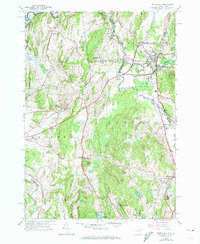 1946 Thorn Hill1974 Print · USGSThe New York and Vermont border comes alive in this mid-century survey of the Poultney and Mettawee river valleys. Genealogists and historians can trace family sites at the William Miller Chapel, find rural schoolhouses like Harlow Sch, or locate the old Landing Field near Fair Haven.2 unique versions available
 - 1948 Map of Thorn Hill
 1948 Thorn Hill1948 Print · USGSThe New York-Vermont border region comes alive in the late 1940s, showing the settled valleys of the Poultney River and Fair Haven. Genealogists and historians can trace local landmarks like the William Miller Chapel, St Marys Cem, and numerous rural schoolhouses.
End of results
Showing maps 1-2 of 2
Top cities near Low Hampton
- Kingsbury historical maps
- Granville historical maps
- Fort Ann historical maps
- Ticonderoga historical maps
- Brandon historical maps
- Whitehall historical maps
See more
Frequently asked questions
- What are the different types of historical maps available for Low Hampton?
- What is the oldest map of Low Hampton?
- Where can I purchase historical maps of Low Hampton for my home or office?
- Where can I download high-res historical maps of Low Hampton?
- Are there historical topographic maps available for Low Hampton?
- Is there historical aerial imagery available for Low Hampton?
- Where are historical maps of Low Hampton sourced from?