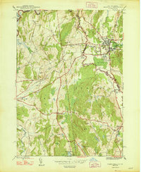
1948 Map of Thorn Hill
USGS Topo · Published 1948About this map
The Poultney River and Castleton River converge near the New York-Vermont border, framing a landscape defined by small-scale farming and local industry in the late 1940s. The settlement of Fair Haven serves as a significant hub on the eastern edge, while rural life in Hampton and Whitehall is anchored by numerous district schools and cemeteries, such as School No 4 and the Cedar Grove Cem. The Delaware and Hudson railroad cuts through the center, connecting the region's productive valleys.
Find a feature on this map
49 named features on this map. Tap any name to fly to it.
Don’t see what you’re looking for? This feature index may not catch every label — zoom into the map to look around manually.
Map Details
Editions of this 1948 Thorn Hill Map
This is the sole edition of this map. No revisions or reprints were ever made.
Other maps of this area

1893 · Fort Ann
USGS Topo · 1:62,500

1893 · Whitehall
USGS Topo · 1:62,500

1894 · Pawlet
USGS Topo · 1:62,500

1895 · Whitehall
USGS Topo · 1:62,500

1895 · Fort Ann
USGS Topo · 1:62,500

1895 · Castleton
USGS Topo · 1:62,500

1897 · Pawlet
USGS Topo · 1:62,500

1897 · Castleton
USGS Topo · 1:62,500

1898 · Whitehall
USGS Topo · 1:62,500

1898 · Fort Ann
USGS Topo · 1:62,500