
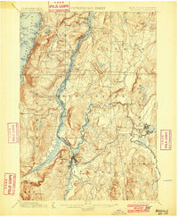
1898 Map of Whitehall
USGS Topo · Published 1898About this map
Whitehall stands at the strategic nexus where the southern tip of Lake Champlain meets the northern reach of the Champlain Division Delaware and Hudson R.R., serving as a critical gateway between the Hudson Valley and the north. The landscape is defined by the narrow, fjord-like waters of The Narrows and the South Bay, flanked by prominent peaks like Skene Mt. and Bald Mountain.
Find a feature on this map
88 named features on this map. Tap any name to fly to it.
Don’t see what you’re looking for? This feature index may not catch every label — zoom into the map to look around manually.
Map Details
Editions of this 1898 Whitehall Map
2 editions found
Other maps of this area

1893 · Fort Ann
USGS Topo · 1:62,500

1893 · Whitehall
USGS Topo · 1:62,500

1894 · Ticonderoga
USGS Topo · 1:62,500

1894 · Pawlet
USGS Topo · 1:62,500

1895 · Whitehall
USGS Topo · 1:62,500

1895 · Fort Ann
USGS Topo · 1:62,500

1895 · Paradox Lake
USGS Topo · 1:62,500

1895 · Glens Falls
USGS Topo · 1:62,500

1895 · Castleton
USGS Topo · 1:62,500

1896 · Ticonderoga
USGS Topo · 1:62,500