1940s Maps of Huron, New York
Explore 4 historic maps of Huron from the 1940s. These maps offer a rare glimpse into what life looked like during the 1940s — showing old roads, neighborhoods, homes, and landmarks that have changed or disappeared over time.
Whether you're researching your family's past, planning a metal detecting trip, or studying how Huron's landscape evolved across the 1940s, these high-resolution maps are a powerful tool for exploring the history of this region.
- Focus on a specific era: All maps on this page are from the 1940s, giving you a focused view of this time period.
- See what’s changed: Compare century-old streets, trails, and buildings to today's modern landscape using overlays and satellite layers.
- Research with precision: Use these maps for genealogy, historical research, land use analysis, or educational projects.
- View, download, or print: Maps are fully viewable online in high resolution, and can be downloaded or printed for your own records.
Start exploring Huron's history through authentic maps from the 1940s. This is your window into the past.
Huron, NY maps
(4)- 1943 Map of Sodus Point
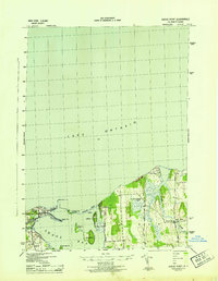 1943 Sodus Point1943 Print · USGSWayne County's Lake Ontario shoreline is captured here during the 1940s, highlighting the area's transition from a rail-to-water shipping hub to a summer retreat. Genealogists can locate School No 13 and St Johns Fishers Chapel or trace the Pennsylvania rail line into Sodus Point.
 - 1943 Map of Wolcott
 1943 Wolcott1943 Print · USGSWayne County farming communities thrive in the early 1940s, connected by a network of rural roads and small hamlets. Genealogists can trace family roots through numerous sites like Sunnyside Church, Butler Savannah Cem, and Maunders Corners.
 - 1943 Map of Rose
 1943 Rose1943 Print · USGSMid-century Wayne County agriculture and shoreline living are on display in this survey of the eastern Sodus Bay region. Genealogists can locate family homesteads near York Settlement, Barton Cem, and numerous district schools like School No 16.
 - 1943 Map of North Wolcott
 1943 North Wolcott1943 Print · USGSCoastal Wayne County during the mid-war years is mapped here in detail, showing the deep inlets of the Lake Ontario shoreline and the rural school districts of the interior. Genealogists can trace family lands near North Wolcott, Desbrough Park, or the historic Park Cem.
End of results
Showing maps 1-4 of 4
Top cities near Huron
- Arcadia historical maps
- Newark historical maps
- Sodus historical maps
- Lyons historical maps
- Galen historical maps
- Wolcott historical maps
See more
Top neighborhoods of Huron
- Sunset View historical maps
- York historical maps
- North Huron historical maps
- Resort historical maps
- East Bay Park historical maps
- Rice Mill historical maps
See more
Frequently asked questions
- What are the different types of historical maps available for Huron?
- What is the oldest map of Huron?
- Where can I purchase historical maps of Huron for my home or office?
- Where can I download high-res historical maps of Huron?
- Are there historical topographic maps available for Huron?
- Is there historical aerial imagery available for Huron?
- Where are historical maps of Huron sourced from?