1940s Maps of Savannah, New York
Explore 4 historic maps of Savannah from the 1940s. These maps offer a rare glimpse into what life looked like during the 1940s — showing old roads, neighborhoods, homes, and landmarks that have changed or disappeared over time.
Whether you're researching your family's past, planning a metal detecting trip, or studying how Savannah's landscape evolved across the 1940s, these high-resolution maps are a powerful tool for exploring the history of this region.
- Focus on a specific era: All maps on this page are from the 1940s, giving you a focused view of this time period.
- See what’s changed: Compare century-old streets, trails, and buildings to today's modern landscape using overlays and satellite layers.
- Research with precision: Use these maps for genealogy, historical research, land use analysis, or educational projects.
- View, download, or print: Maps are fully viewable online in high resolution, and can be downloaded or printed for your own records.
Start exploring Savannah's history through authentic maps from the 1940s. This is your window into the past.
Savannah, NY maps
(4)- 1943 Map of Montezuma
 1943 Montezuma1943 Print · USGSThe Cayuga County marshlands are captured here during the Second World War as the region’s massive river and canal systems were being managed for conservation. You can trace the early path of the Erie Canal (Abandoned) or find family sites near Port Byron and Murray Cem.
 - 1943 Map of Savannah
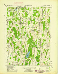
 1943 Savannah1943 Print · USGSThe marshlands and waterways of Wayne County are captured here in the 1940s, highlighting the vital corridor of the Erie Canal and Clyde River. Family historians can trace old homesteads near Hunt Corners, Lockpit Cem, and several numbered schoolhouses.
 - 1943 Map of Wolcott
 1943 Wolcott1943 Print · USGSWayne County farming communities thrive in the early 1940s, connected by a network of rural roads and small hamlets. Genealogists can trace family roots through numerous sites like Sunnyside Church, Butler Savannah Cem, and Maunders Corners.
 - 1943 Map of Red Creek
 1943 Red Creek1943 Print · USGSUpper New York state during the early 1940s shows a landscape of small farming hamlets and rural school districts along the Wayne and Cayuga county line. Researchers can trace historic cemeteries like French Cem, early landmarks like the Airport, and old district schoolhouses.
End of results
Showing maps 1-4 of 4
Top cities near Savannah
- Auburn historical maps
- Geneva historical maps
- Seneca Falls historical maps
- Sodus historical maps
- Waterloo historical maps
- Seneca Falls historical maps
See more
Top neighborhoods of Savannah
- Noble Corner historical maps
- Evans Corner historical maps
- Fort Hill historical maps
- Savannah historical maps
Frequently asked questions
- What are the different types of historical maps available for Savannah?
- What is the oldest map of Savannah?
- Where can I purchase historical maps of Savannah for my home or office?
- Where can I download high-res historical maps of Savannah?
- Are there historical topographic maps available for Savannah?
- Is there historical aerial imagery available for Savannah?
- Where are historical maps of Savannah sourced from?