Old Maps of Wyoming County, New York for Hiking & Exploration
Hike through history with 126 historic maps of Wyoming County. Explore old trails, ghost towns, and forgotten backroads — perfect for outdoor adventurers and local explorers.
- Rediscover forgotten places: Map out old mining camps, roads, and footpaths that no longer exist on modern maps.
- Layer with modern tools: Combine with LiDAR or satellite views to plan hikes through historical terrain.
- Made for exploration: Popular among hikers, overlanders, and local history lovers.
Use these maps to find adventure and explore the hidden past of Wyoming County.
Wyoming County, NY maps
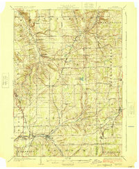
(126)- 1904 Map of Batavia
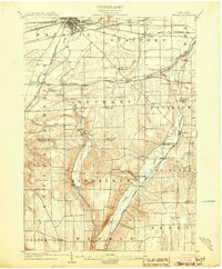 1904 Batavia1904 Print · USGSWestern New York at the turn of the century shows a landscape dominated by competing railroad interests and agricultural hamlets. Genealogists can trace family connections between Pearl Creek, Attica Center, and Stafford while following the routes of the Lehigh Valley and Erie R. R. through the valleys.7 unique versions available
 - 1904 Map of Caledonia
 1904 Caledonia1904 Print · USGSLivingston County and its surrounding borders are shown here at the height of the early railroad era. Researchers can trace the complex rail junctions at Caledonia or locate vanished landmarks and post offices like Wadsworth P.O. S.Greigsville and Retsof.6 unique versions available
 - 1905 Map of Attica
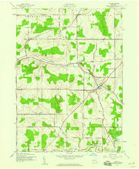
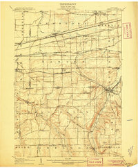 1905 Attica1905 Print · USGSWestern New York at the turn of the century shows a landscape dominated by a massive web of competing railroads. Genealogists can trace family names and small hamlets like Folsomdale, Darien Center, and the industrial hub at Attica.5 unique versions available
 - 1905 Map of Portage
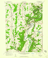
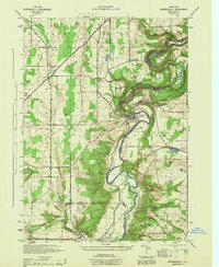
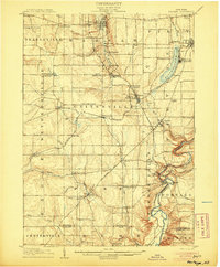 1905 Portage1905 Print · USGSWyoming County at the turn of the century shows a landscape defined by the deep gorge of the Genesee River and a busy rail network. Genealogists can trace family names at Halls Corners, explore the Silver Lake Assembly, or locate the mills and stations at Rock Glen and Portageville.6 unique versions available
 - 1905 Map of Nunda
 1905 Nunda1905 Print · USGSLivingston County rail and river life are captured here at the turn of the century, centered on the Genesee River valley. Trace the vanished streets of St Helena, locate the Sonyea P O Craig Colony, and follow the complex rail junctions at Mount Morris.6 unique versions available
 - 1923 Map of Arcade, 1957 Print
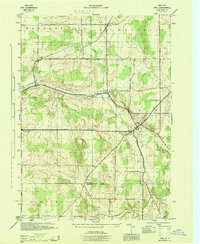
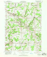
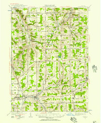 1923 Arcade1957 Print · USGSWyoming County is captured in the early 1920s, showing a landscape defined by dairy farming and the vital rail connections of the Arcade and Attica. Genealogists can trace family names at Hicks Corners and Toziers Corners, or locate rural landmarks like Klein School and Java Lake.2 unique versions available
 - 1925 Map of Arcade
 1925 Arcade1925 Print · USGSWestern New York’s rural landscape is captured here in the mid-1920s, a time when one-room schoolhouses and family-named crossroads still defined the countryside. Genealogists can trace property vicinities near Java Village, locate the elusive Cheery Tavern, or follow the path of the Arcade and Attica railroad.4 unique versions available
 - 1943 Map of Mount Morris
 1943 Mount Morris1943 Print · USGSDuring the war years, this corner of the Genesee Valley was a landscape of dramatic river gorges and quiet upland farming. Genealogists and historians can trace the early road networks connecting Mount Morris and Perry or locate rural hamlets like Brooks Grove and Simmons Corners.2 unique versions available
 - 1943 Map of Warsaw, 1959 Print
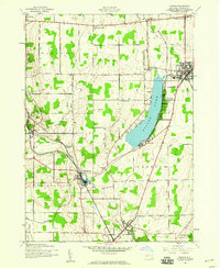
 1943 Warsaw1959 Print · USGSWyoming County agricultural life and rail infrastructure are captured here during the mid-century. Researchers can trace historic property locations near the crossroads of Halls Corners or along the lines of the Erie and Baltimore and Ohio railroads.
 - 1943 Map of Nunda, 1960 Print
 1943 Nunda1960 Print · USGSLivingston County's agricultural valleys and steep gorges are captured here during the early 1940s. Genealogists and rail historians can trace the routes of the Pennsylvania and Erie lines through Dalton, Nunda, and the rural crossing at Nunda Junction.
 - 1943 Map of Castile, 1960 Print
 1943 Castile1960 Print · USGSMid-century Wyoming County centers on the busy waters of Silver Lake and the critical rail crossings of the war years. Local historians can trace the paths of the Baltimore and Ohio railroad through Silver Springs, Castile, and the junction at Rock Glen.
 - 1943 Map of Portageville, 1960 Print
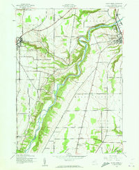
 1943 Portageville1960 Print · USGSThe Genesee River valley in the early 1940s shows a landscape defined by dramatic waterfalls and the vital corridors of the Erie and Pennsylvania railroads. Trace the industrial footprints of Mills Mills and Bluestone or locate family roots near Portageville.
 - 1943 Map of Pike, 1966 Print
 1943 Pike1966 Print · USGSWyoming County farming communities and the southern tier rail corridor are captured here during the mid-1940s. Genealogists can trace family lands near Pike, Bliss, and Hardys, or locate landmarks along the Baltimore and Ohio railroad.
 - 1944 Map of Nunda
 1944 Nunda1944 Print · USGSLivingston and Allegany counties are shown here during the mid-forties, capturing the rural rail-and-river network of the Genesee Valley. Researchers can trace historic family-named routes and vanished sidings at Nunda Junction, Hunts Hollow, and Dalton.
 - 1944 Map of Pike
 1944 Pike1944 Print · USGSThe rural landscapes of Wyoming and Allegany counties were still largely shaped by nineteenth-century farm patterns when this survey was conducted during the war. Researchers can trace the layout of family lands and crossroads settlements like Bliss, Eagle Center, and Pike, or follow the course of Wiscoy Creek and Cold Creek.
 - 1944 Map of Mount Morris
 1944 Mount Morris1944 Print · USGSThe Genesee Valley during the mid-forties was a landscape of dramatic river bluffs and vital rail junctions. Genealogists and local historians can trace family-named routes like Hendershot Road and locate rural hubs such as Brooks Grove and Ridge.
 - 1944 Map of Warsaw
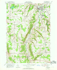
 1944 Warsaw1944 Print · USGSWyoming County is captured in the mid-1940s, centered on the valley village of Warsaw as it sits between the high plateaus of Wethersfield and Gainesville. Researchers can trace the rail paths of the Erie and Baltimore Ohio or locate rural hamlets like Hermitage and Wethersfield Springs.
 - 1944 Map of Castile
 1944 Castile1944 Print · USGSWyoming County at the height of the mid-century salt and rail era shows a landscape of busy junctions and lakeside settlements. Trace the industrial footprint of the Worcester Salt Works and the rail corridors through Silver Springs and Rock Glen.
 - 1944 Map of Leicester
 1944 Leicester1944 Print · USGSLivingston County’s Genesee Valley was a powerhouse of rail transport and rural industry in the mid-forties. Genealogists and industrial historians can trace early property lines near Olivet Cem, find School No 7, and follow the junction of the Genesee and Wyoming Railroad through Retsof and Leicester.
 - 1944 Map of Portageville
 1944 Portageville1944 Print · USGSThe Genesee River valley in the mid-1940s is defined by its dramatic falls and the intersection of rail lines like the Erie and Pennsylvania. Genealogists and historians can trace the rural communities of Portageville, Wiscoy, and Mills during this wartime era.
 - 1949 Map of Attica, 1953 Print
 1949 Attica1953 Print · USGSWestern New York at mid-century reveals a dense network of major railroads and rural hamlets across Genesee and Wyoming counties. Genealogists and historians can trace family locations through numerous numbered schools, named crossroads like Brick House Corners, and landmarks such as the Attica State Prison.
 - 1949 Map of Cowlesville, 1969 Print
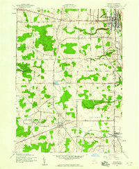
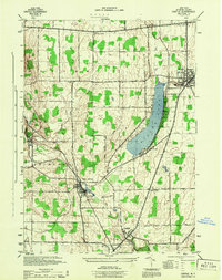
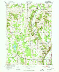
 1949 Cowlesville1969 Print · USGSWyoming County's rural character is well-preserved here in the years following the war, showing a landscape defined by small crossroads hamlets and creek-side settlements. Genealogists can trace family roots through sites like Persons Corners, Persons Cem, and several numbered schoolhouses including School No 19.
 - 1949 Map of Attica, 1969 Print
 1949 Attica1969 Print · USGSWestern New York’s rural landscape is captured here in the late 1940s, centered on the rail hub of Attica. Researchers can trace the dual rail lines of the Erie RR and Attica and Arcade RR or locate family sites near Varysburg and East Bennington.2 unique versions available
 - 1949 Map of Dale, 1974 Print
 1949 Dale1974 Print · USGSMid-century Wyoming County is defined by the winding Erie Railroad and a network of rural hamlets. Local historians can trace family-named crossroads and burial sites like Sickleys Corners, Vernal Corners Cem, and Dutton Hill.3 unique versions available
 - 1950 Map of Elmira
 1950 Elmira1950 Print · USGSThe Finger Lakes region thrived in the late 1940s as a hub of industry and transport. Trace family roots and vanished landmarks near Seneca Lake or explore the rail lines of the Erie RR and the sprawling Seneca Ordnance Depot.2 unique versions available
Showing maps 1-25 of 126
Top cities of Wyoming County
- Perry historical maps
- Attica historical maps
- Warsaw historical maps
- Arcade historical maps
- Perry historical maps
- Bennington historical maps
See more
Frequently asked questions
- What are the different types of historical maps available for Wyoming County?
- What is the oldest map of Wyoming County?
- Where can I purchase historical maps of Wyoming County for my home or office?
- Where can I download high-res historical maps of Wyoming County?
- Are there historical topographic maps available for Wyoming County?
- Is there historical aerial imagery available for Wyoming County?
- Where are historical maps of Wyoming County sourced from?