2000-2009 Maps of Anson County, North Carolina
Explore 6 historic maps of Anson County from 2000-2009. These maps offer a rare glimpse into what life looked like during the 2000s — showing old roads, neighborhoods, homes, and landmarks that have changed or disappeared over time.
Whether you're researching your family's past, planning a metal detecting trip, or studying how Anson County's landscape evolved across the 2000s, these high-resolution maps are a powerful tool for exploring the history of this region.
- Focus on a specific era: All maps on this page are from the 2000s, giving you a focused view of this time period.
- See what’s changed: Compare century-old streets, trails, and buildings to today's modern landscape using overlays and satellite layers.
- Research with precision: Use these maps for genealogy, historical research, land use analysis, or educational projects.
- View, download, or print: Maps are fully viewable online in high resolution, and can be downloaded or printed for your own records.
Start exploring Anson County's history through authentic maps from the 2000s. This is your window into the past.
Anson County, NC maps
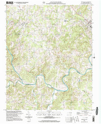
(6)- 2002 Map of Mangum
 2002 Mangum2002 Print · USGSThe Pee Dee River basin at the Anson and Richmond county line shows a landscape shaped by river transport and rural community life. Genealogists and local historians can trace family roots through numerous sites like Hebron Ch, Ingram Sch, and the historical Old Stanback Ferry.
 - 2002 Map of Aquadale, 2003 Print
 2002 Aquadale2003 Print · USGSThe Piedmont landscape of Stanly and Anson counties is shown here at the turn of the millennium, following the winding course of the Rocky River. Genealogists and historians can trace community life through numerous rural landmarks like Rehobeth Ch, Poplar Springs Ch, and the settlement at Cottonville.
 - 2002 Map of Mount Gilead West, 2003 Print
 2002 Mount Gilead West2003 Print · USGSThe Pee Dee River corridor at the turn of the millennium shows a landscape defined by its hydroelectric infrastructure and rural crossroads. Local researchers can trace family landmarks and community centers such as Bethel Ch, Melton Grove, and St Lukes Ch across four adjoining counties.
 - 2002 Map of Marshville, 2003 Print
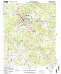
 2002 Marshville2003 Print · USGSMarshville and the surrounding Piedmont countryside are captured here at the start of the new millennium. Researchers can trace rural life through landmarks like Sturdivants Crossroads, White Store, and the many local congregations including Gilboa Ch.
 - 2002 Map of Wadesboro, 2003 Print
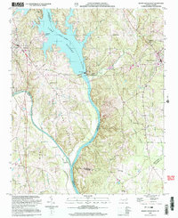
 2002 Wadesboro2003 Print · USGSAnson County at the turn of the millennium shows the enduring rural character of its settlements and the growth of the county seat. Genealogists and local historians can trace the locations of numerous landmarks including East View Cem, Gatewood Sta Ch, and the outlying Wade Mills.
 - 2002 Map of Russellville, 2003 Print
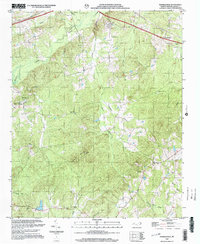 2002 Russellville2003 Print · USGSAnson County at the turn of the millennium retains its deep-rooted rural character, defined by creek-side settlements and country churches. Genealogists and historians can locate Polkton, the State Prison Camp, and several landmarks like Unity Chapel and Poplar Hill Ch.
End of results
Showing maps 1-6 of 6
Top cities of Anson County
- Wadesboro historical maps
- Polkton historical maps
- Ansonville historical maps
- Morven historical maps
- Peachland historical maps
- Lilesville historical maps
See more
Frequently asked questions
- What are the different types of historical maps available for Anson County?
- What is the oldest map of Anson County?
- Where can I purchase historical maps of Anson County for my home or office?
- Where can I download high-res historical maps of Anson County?
- Are there historical topographic maps available for Anson County?
- Is there historical aerial imagery available for Anson County?
- Where are historical maps of Anson County sourced from?