1990s Maps of Roxobel, North Carolina
Explore 2 historic maps of Roxobel from the 1990s. These maps offer a rare glimpse into what life looked like during the 1990s — showing old roads, neighborhoods, homes, and landmarks that have changed or disappeared over time.
Whether you're researching your family's past, planning a metal detecting trip, or studying how Roxobel's landscape evolved across the 1990s, these high-resolution maps are a powerful tool for exploring the history of this region.
- Focus on a specific era: All maps on this page are from the 1990s, giving you a focused view of this time period.
- See what’s changed: Compare century-old streets, trails, and buildings to today's modern landscape using overlays and satellite layers.
- Research with precision: Use these maps for genealogy, historical research, land use analysis, or educational projects.
- View, download, or print: Maps are fully viewable online in high resolution, and can be downloaded or printed for your own records.
Start exploring Roxobel's history through authentic maps from the 1990s. This is your window into the past.
Roxobel, NC maps
(2)- 1997 Map of Kelford, 2000 Print
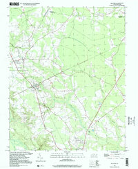 1997 Kelford2000 Print · USGSThe interconnected communities of Bertie County appear here in the late twentieth century, showing a landscape defined by agriculture and winding swamp systems. Researchers can locate local landmarks like the Peanut Belt Research Station, Beautiful Zion Ch, and the Roxobel-Kelford Cem.
 - 1997 Map of Norfleet, 2000 Print
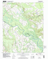 1997 Norfleet2000 Print · USGSThe Roanoke River lowlands of Northampton and Halifax counties are captured here at the close of the twentieth century. Genealogists can trace family footprints through numerous rural burial sites like Norfleet Cem and churches including St Stevens Ch.
End of results
Showing maps 1-2 of 2
Top cities near Roxobel
- Ahoskie historical maps
- Scotland Neck historical maps
- Rich Square historical maps
- Aulander historical maps
- Woodland historical maps
- Conway historical maps
See more
Frequently asked questions
- What are the different types of historical maps available for Roxobel?
- What is the oldest map of Roxobel?
- Where can I purchase historical maps of Roxobel for my home or office?
- Where can I download high-res historical maps of Roxobel?
- Are there historical topographic maps available for Roxobel?
- Is there historical aerial imagery available for Roxobel?
- Where are historical maps of Roxobel sourced from?