1940s Maps of Brunswick County, North Carolina
Explore 29 historic maps of Brunswick County from the 1940s. These maps offer a rare glimpse into what life looked like during the 1940s — showing old roads, neighborhoods, homes, and landmarks that have changed or disappeared over time.
Whether you're researching your family's past, planning a metal detecting trip, or studying how Brunswick County's landscape evolved across the 1940s, these high-resolution maps are a powerful tool for exploring the history of this region.
- Focus on a specific era: All maps on this page are from the 1940s, giving you a focused view of this time period.
- See what’s changed: Compare century-old streets, trails, and buildings to today's modern landscape using overlays and satellite layers.
- Research with precision: Use these maps for genealogy, historical research, land use analysis, or educational projects.
- View, download, or print: Maps are fully viewable online in high resolution, and can be downloaded or printed for your own records.
Start exploring Brunswick County's history through authentic maps from the 1940s. This is your window into the past.
Brunswick County, NC maps
(29)- 1942 Map of Wilmington
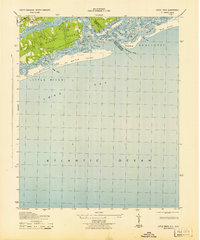
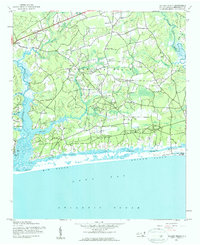
 1942 Wilmington1942 Print · USGSWilmington and its coastal sounds are shown during the early years of the war, when the riverfront and beach communities were expanding. Researchers can trace family-named landmarks like Everett Creek, the riverside Ruins Anderson Landing, and the seaside Seabreeze resort.
 - 1942 Map of Cape Fear, 1956 Print
 1942 Cape Fear1956 Print · USGSCape Fear and Smith Island are captured here during the early 1940s, serving as a critical coastal outpost. Researchers can trace the wartime infrastructure of the Atlantic coast, from the Cape Fear Lighthouse to the Coast Guard Tower and Signal Mast.
 - 1942 Map of Juniper Creek, 1962 Print
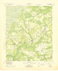
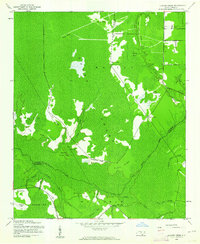 1942 Juniper Creek1962 Print · USGSThe North Carolina coastal plain in the early 1940s reveals a world of vast swamp forests and isolated ridge settlements. Researchers can locate the Waccamaw Institute and trace old family landmarks like Clewis Corner or Bennett Little Field.
 - 1943 Map of Little River
 1943 Little River1943 Print · USGSThe coastal border between Horry County and Brunswick County is captured here in the early 1940s, highlighting a landscape of tidal marshes and barrier islands. Researchers can trace the early layout of Little River and find landmarks like The Battery, Goat Island, and Futch Beach.
 - 1943 Map of Pireway
 1943 Pireway1943 Print · USGSCoastal Carolina and the borderlands near the Waccamaw River appear here during the wartime years, showing a landscape defined by expansive swamps and rural bay formations. Genealogists can trace family roots through the Dothans Sch, the Old Tram Road, and local landmarks like Dulah Mormon Church.
 - 1943 Map of Calabash
 1943 Calabash1943 Print · USGSThe coastal borderlands of North Carolina and South Carolina are captured here during the early forties, showing a landscape of dense swamps and timber bays. Genealogists can locate family landmarks like Philadelphia Wesley Church, Hickmans Crossroads, and the school at La Savannah Sch.
 - 1943 Map of Funston, 1962 Print
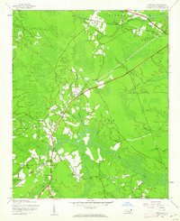
 1943 Funston1962 Print · USGSCoastal Brunswick County during the early 1940s is shown here as a landscape of interconnected wetlands and small rural outposts. Researchers can trace family-named water features and local landmarks like Brunswick Station, Christian Chapel, and Orton Pond.2 unique versions available
 - 1943 Map of Freeland, 1962 Print
 1943 Freeland1962 Print · USGSCoastal North Carolina during the mid-century is captured here as a landscape of dense swamps and winding river systems. Genealogists can locate family landmarks such as the Smith Cem, Soldier Bay Ch, and small settlements like Regan and Reeves.
 - 1943 Map of Honey Island, 1962 Print
 1943 Honey Island1962 Print · USGSCoastal North Carolina's interior wetlands are captured here in the 1940s, showing the intersection of Brunswick and Columbus counties. Researchers can trace the Old Railroad Grade through the Green Swamp or locate the Waccamaw Institute and Riegel Lookout Tower.
 - 1943 Map of Holden Beach, 1962 Print
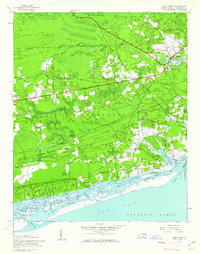
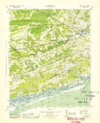
 1943 Holden Beach1962 Print · USGSCoastal Brunswick County is captured here in the 1940s, showing the quiet marshlands and river necks before significant shoreline development. Researchers can trace the roots of the barrier island at Holden Beach and find inland sites like Sivey Town and Sabbath Haven Ch.
 - 1943 Map of Winnabow, 1962 Print
 1943 Winnabow1962 Print · USGSCoastal North Carolina's rural interior comes into focus here during the early 1940s, showing a landscape defined by timber, swamps, and small community hubs. Researchers can trace family history through old landmarks like Bell Swamp Sch, Benton Cem, and the Abandoned Railroad Grade.2 unique versions available
 - 1943 Map of Exum, 1962 Print
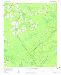
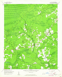
 1943 Exum1962 Print · USGSBrunswick County at the height of the Second World War reveals a landscape defined by the deep reaches of the Green Swamp. Local historians can trace family ties at Union Ch and Milligan Cem, or follow the Old RR Grade through the timbered wetlands.
 - 1943 Map of Bolivia, 1962 Print
 1943 Bolivia1962 Print · USGSCoastal Brunswick County in the early 1940s is characterized by its sprawling wetlands and small crossroads communities. Genealogists and researchers can trace local landmarks like Mt Olive Ch, the Bolivia Lookout Tower, and the settlement of Antioch.
 - 1943 Map of Lockwoods Folly, 1962 Print
 1943 Lockwoods Folly1962 Print · USGSCoastal Brunswick County is shown here during the early 1940s, when the shoreline was defined by quiet landings and maritime forest. Genealogists and historians can trace family-named landmarks and old settlements like Varnum Town, Dixon Chapel, and Holden Beach.
 - 1943 Map of Supply, 1962 Print
 1943 Supply1962 Print · USGSCoastal Brunswick County in the 1940s is defined by the vast Green Swamp and the small settlements emerging along its edges. Genealogists and researchers can trace local landmarks like Prospect Ch, Royal Oak Sch, and the Railroad Grade.2 unique versions available
 - 1943 Map of Lewis Swamp, 1962 Print
 1943 Lewis Swamp1962 Print · USGSCoastal North Carolina during the mid-forties reveals a landscape defined by the wetlands of the Green Swamp and local timber history. Researchers can locate family landmarks such as the Old Cumbee Place, identify rural congregations like Christian Hope Ch, and trace the paths of an Old Railroad Grade.
 - 1943 Map of Shallotte, 1962 Print
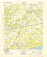
 1943 Shallotte1962 Print · USGSThe Brunswick County coast in the 1940s reveals a quiet network of tidal sounds and timberlands before modern development. Genealogists can trace family sites like Russtown, Register Cem, and local landmarks such as Brick Landing and Mintz Dam.
 - 1944 Map of Longs
 1944 Longs1944 Print · USGSCoastal South Carolina and North Carolina were defined by river ferries and swamp agriculture during the mid-forties. Genealogists can trace local family landmarks such as Butler Cem, Buck Creek Church, and the former Olyphic PO.
 - 1944 Map of Supply
 1944 Supply1944 Print · USGSBrunswick County during the Second World War shows a coastal landscape of timber roads and rural church communities. Trace family roots and local landmarks from Prospect to the Lockwoods Folly Bridge, including the Royal Oak School and Concord Church.
 - 1944 Map of Bolivia
 1944 Bolivia1944 Print · USGSMid-century Brunswick County is captured here during a period of transition for its coastal swamp communities. Genealogists and historians can trace family-named landmarks and old congregations at St Johns Ch, Antioch Ch, and the settlement of Bolivia.
 - 1944 Map of Winnabow
 1944 Winnabow1944 Print · USGSCoastal Brunswick County is captured here during the mid-forties, showing a landscape defined by tidewater creeks and rural crossroads. Researchers can trace family sites and local landmarks like Winnabow School, Nelson Cem, and the discontinued Wilmington Brunswick and Southern railroad.
 - 1944 Map of Lockwoods Folly
 1944 Lockwoods Folly1944 Print · USGSThe Brunswick County coast during the 1940s reveals a landscape of tidal marshes and quiet river landings before the era of modern development. Trace the maritime history of Varnum Town and follow family-named landmarks like Gores Ldg and the uniquely named Half Hell Road.
 - 1944 Map of Shallotte
 1944 Shallotte1944 Print · USGSThe Brunswick County coast comes alive in the 1940s, showing the intricate tidal networks and small communities of the North Carolina shore. Trace local heritage through landmarks like Russtown, the Brunswick Co School, and the Coast Guard Station at the inlet.
 - 1944 Map of Lewis Swamp
 1944 Lewis Swamp1944 Print · USGSCoastal North Carolina during the mid-forties reveals a landscape of dense swamps and scattered rural settlements like Batarora and Rabontown. Genealogists can locate family landmarks such as the Old Cumbee Place and Flowers Corner alongside local country churches.
 - 1946 Map of Southport
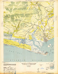 1946 Southport1946 Print · USGSImmediately following the war, this coastal area shows the intersection of maritime defense and river-based commerce. Researchers can trace family landmarks and civic sites like the Brunswick Co Home, Browns Ch, and the grounds of Fort Caswell.
Showing maps 1-25 of 29
Top cities of Brunswick County
- Leland historical maps
- Oak Island historical maps
- Boiling Spring Lakes historical maps
- Southport historical maps
- Sunset Beach historical maps
- Carolina Shores historical maps
See more
Frequently asked questions
- What are the different types of historical maps available for Brunswick County?
- What is the oldest map of Brunswick County?
- Where can I purchase historical maps of Brunswick County for my home or office?
- Where can I download high-res historical maps of Brunswick County?
- Are there historical topographic maps available for Brunswick County?
- Is there historical aerial imagery available for Brunswick County?
- Where are historical maps of Brunswick County sourced from?