1980s Maps of Brunswick County, North Carolina
Explore 19 historic maps of Brunswick County from the 1980s. These maps offer a rare glimpse into what life looked like during the 1980s — showing old roads, neighborhoods, homes, and landmarks that have changed or disappeared over time.
Whether you're researching your family's past, planning a metal detecting trip, or studying how Brunswick County's landscape evolved across the 1980s, these high-resolution maps are a powerful tool for exploring the history of this region.
- Focus on a specific era: All maps on this page are from the 1980s, giving you a focused view of this time period.
- See what’s changed: Compare century-old streets, trails, and buildings to today's modern landscape using overlays and satellite layers.
- Research with precision: Use these maps for genealogy, historical research, land use analysis, or educational projects.
- View, download, or print: Maps are fully viewable online in high resolution, and can be downloaded or printed for your own records.
Start exploring Brunswick County's history through authentic maps from the 1980s. This is your window into the past.
Brunswick County, NC maps
(19)- 1980 Map of Castle Hayne, 1985 Print
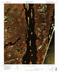
 1980 Castle Hayne1985 Print · USGSThe coastal plains north of Wilmington are revealed in this 1980 infrared survey, showing the expansion of rural communities into the surrounding timberlands. Trace the winding Northeast Cape Fear River and the early footprints of Castle Hayne and Wrightsboro.2 unique versions available
 - 1980 Map of Carolina Beach, 1985 Print
 1980 Carolina Beach1985 Print · USGSThe North Carolina coast in the early eighties appears in striking infrared detail, showing the developed shoreline and the winding Cape Fear. Local historians can trace the paths of Snows Cut and locate landmarks like Kendall Chapel or the waters of Orton Pond.2 unique versions available
 - 1980 Map of Acme, 1985 Print
 1980 Acme1985 Print · USGSCoastal North Carolina industrial and rail corridors are captured in this early 1980s infrared survey of the lower Cape Fear region. Researchers can trace the development of Riegelwood and the historic railway hamlets of Delco, Acme, and Maco.
 - 1980 Map of Leland, 1985 Print
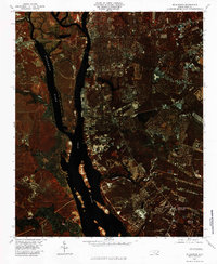
 1980 Leland1985 Print · USGSCoastal Brunswick County is captured in the early eighties as its riverfront towns began to expand near the Cape Fear. Genealogists and local historians can locate early settlements like Phoenix and Malmo or trace the winding course of Hood Creek.
 - 1980 Map of Lewis Swamp, 1985 Print
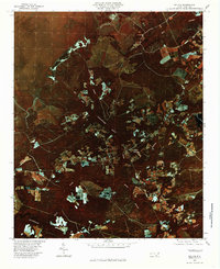
 1980 Lewis Swamp1985 Print · USGSCoastal North Carolina's rural landscape is revealed in this 1980 color infrared study of the wetlands and timberlands. Researchers can trace remote crossroads and family-named locales such as Rabontown, Flowers Corner, and the depths of Green Swamp.
 - 1980 Map of Kure Beach, 1985 Print
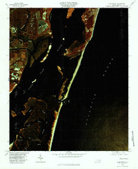 1980 Kure Beach1985 Print · USGSThe North Carolina coast and the mouth of the Cape Fear River appear in vivid detail in the early eighties. Researchers can trace the shifting sands of Smith Island and the intricate tidal waterways of Buzzard Bay and Muddy Slough.
 - 1980 Map of Lockwoods Folly, 1985 Print
 1980 Lockwoods Folly1985 Print · USGSCoastal Brunswick County comes into focus in this early 1980s aerial survey, revealing the intersection of timberland, swamp, and sea. Genealogists and historians can trace the rural layouts of Varnum Town and Lennon Crossroads along the banks of the Lockwoods Folly River.
 - 1980 Map of Winnabow, 1985 Print
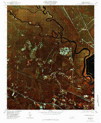
 1980 Winnabow1985 Print · USGSIn the early 1980s, the Brunswick County coastal plain remained a patchwork of dense timber and quiet settlements. Researchers can trace rural property boundaries and old community hubs like Winnabow, Lanvale, and the winding banks of Town Creek.
 - 1980 Map of Cape Fear, 1985 Print
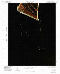 1980 Cape Fear1985 Print · USGSThe tip of the North Carolina coast is captured in the early 1980s via infrared aerial photography. Researchers can trace the natural shoreline of Smith Island and the drainage of Cape Creek near the point of Cape Fear.2 unique versions available
 - 1980 Map of Bolivia, 1985 Print
 1980 Bolivia1985 Print · USGSCoastal Brunswick County in the early eighties is captured here in striking detail, showing the rural landscape around Bolivia. Researchers can trace the path of the Lockwoods Folly River and find local settlements like Piney Grove and Antioch.
 - 1980 Map of Wilmington, 1985 Print
 1980 Wilmington1985 Print · USGSWilmington and the lower Cape Fear region appear in high-resolution detail in this 1980 color infrared study. Researchers can trace the riverfront development of Wilmington and the rural reaches of Town Creek and Myrtle Grove.
 - 1980 Map of Funston, 1985 Print
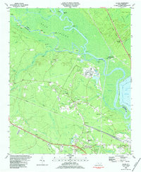
 1980 Funston1985 Print · USGSCoastal development meets the low-lying wetlands of Brunswick County in the early eighties as Boiling Spring Lakes begins to expand. Researchers can trace the layout of residential streets near Brunswick Station and follow the intricate waterways of Orton Creek and Bell Swamp.
 - 1980 Map of Southport, 1985 Print
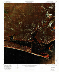 1980 Southport1985 Print · USGSThe Brunswick County coast comes into focus in the early eighties, showing the transition from historic river ports to growing beach communities. Genealogists and historians can trace the foundations of Yaupon Beach, the fortifications at Fort Caswell, and the waterfront at Southport.
 - 1984 Map of Acme
 1984 Acme1984 Print · USGSCoastal North Carolina settlements at the confluence of three counties are captured here in the early eighties. Genealogists and local historians can trace family roots through numerous landmarks like Sykes Cemetery, Farmers Chapel, and the Acme-Delco School.
 - 1984 Map of Leland
 1984 Leland1984 Print · USGSCoastal Brunswick County in the mid-eighties shows a landscape of industrial expansion alongside ancient river systems. Genealogists and historians can trace rail history at Davis Yard or locate rural landmarks like Hooper Chapel and Lincoln Sch.2 unique versions available
 - 1984 Map of Wilmington, 1985 Print
 1984 Wilmington1985 Print · USGSThe Lower Cape Fear region is shown here in the mid-1980s as the coastal corridor between Wilmington and the barrier islands experienced significant development. Researchers can trace historic river landings, the winding Intracoastal Waterway, and established communities from Castle Hayne to Topsail Beach.
 - 1984 Map of Cape Fear, 1985 Print
 1984 Cape Fear1985 Print · USGSThe Carolina coast at the mouth of the river is captured here in the mid-1980s, showcasing a mix of strategic military sites and barrier island geography. Researchers can trace the boundaries of the Military Ocean Terminal Sunny Point and the grounds of the Fort Fisher State Historic Site.
 - 1986 Map of Whiteville
 1986 Whiteville1986 Print · USGSSoutheastern North Carolina and the South Carolina borderlands are captured here in the mid-1980s as a landscape of vast swamps and rail towns. Researchers can trace historic rail routes through Chadbourn, locate the namesake Lake Waccamaw, and explore family-named sites like Peacocks.
 - 1986 Map of Myrtle Beach
 1986 Myrtle Beach1986 Print · USGSThe Grand Strand and Brunswick County coast are captured in the mid-eighties before the late-century development boom. Researchers can trace the footprint of the Myrtle Beach Air Force Base and old coastal settlements like Atlantic Beach and Socastee.
End of results
Showing maps 1-19 of 19
Top cities of Brunswick County
- Leland historical maps
- Oak Island historical maps
- Boiling Spring Lakes historical maps
- Southport historical maps
- Sunset Beach historical maps
- Carolina Shores historical maps
See more
Frequently asked questions
- What are the different types of historical maps available for Brunswick County?
- What is the oldest map of Brunswick County?
- Where can I purchase historical maps of Brunswick County for my home or office?
- Where can I download high-res historical maps of Brunswick County?
- Are there historical topographic maps available for Brunswick County?
- Is there historical aerial imagery available for Brunswick County?
- Where are historical maps of Brunswick County sourced from?