1990s Maps of Shallotte, North Carolina
Explore 6 historic maps of Shallotte from the 1990s. These maps offer a rare glimpse into what life looked like during the 1990s — showing old roads, neighborhoods, homes, and landmarks that have changed or disappeared over time.
Whether you're researching your family's past, planning a metal detecting trip, or studying how Shallotte's landscape evolved across the 1990s, these high-resolution maps are a powerful tool for exploring the history of this region.
- Focus on a specific era: All maps on this page are from the 1990s, giving you a focused view of this time period.
- See what’s changed: Compare century-old streets, trails, and buildings to today's modern landscape using overlays and satellite layers.
- Research with precision: Use these maps for genealogy, historical research, land use analysis, or educational projects.
- View, download, or print: Maps are fully viewable online in high resolution, and can be downloaded or printed for your own records.
Start exploring Shallotte's history through authentic maps from the 1990s. This is your window into the past.
Shallotte, NC maps
(6)- 1990 Map of Myrtle Beach
 1990 Myrtle Beach1990 Print · USGSThe Grand Strand and the North Carolina borderlands are captured here in the decade before the base closure. Genealogists and historians can trace the development of Myrtle Beach and North Myrtle Beach alongside rural landmarks like Star Bluff Crossroads and Fort Caswell.
 - 1990 Map of Exum
 1990 Exum1990 Print · USGSThis coastal North Carolina interior was still a landscape of vast wetlands and scattered settlements in the 1990s. Genealogists and local historians can trace family ties at Exum and Makatoka, or find rural landmarks like St Matthew Ch and Griffin Cem.
 - 1990 Map of Whiteville
 1990 Whiteville1990 Print · USGSSoutheastern North Carolina and the South Carolina borderlands appear in the late twentieth century, showing a landscape of river-swamps and tobacco towns. Researchers can trace family history through sites like Mount Olive Ch, the Seaboard Coast Line RR, and rural centers like Tabor City.
 - 1990 Map of Supply, 1991 Print
 1990 Supply1991 Print · USGSCoastal Brunswick County in the late eighties reveals a landscape transitioning from the wild Green Swamp to the growing community center of Supply. Researchers can locate family landmarks like Prospect Cem and Galloway Cem, or trace the winding course of the Lockwoods Folly River.
 - 1990 Map of Shallotte, 1991 Print
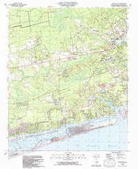 1990 Shallotte1991 Print · USGSThe North Carolina coast at the dawn of the 1990s showcases a transition between quiet wetlands and emerging beach communities. Local historians can trace the growth of Shallotte and Ocean Isle Beach while locating family landmarks like Mintz Cemetery and the Union School.
 - 1990 Map of Holden Beach, 1991 Print
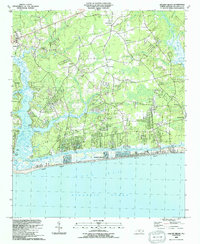 1990 Holden Beach1991 Print · USGSThe Brunswick County coast in the early nineties shows a landscape of developing beach communities and quiet inland settlements. Genealogists and local historians can trace family landmarks like Sabbath Home Ch, Varnamtown, and the old site of Holden Ferry.
End of results
Showing maps 1-6 of 6
Top cities near Shallotte
- North Myrtle Beach historical maps
- Oak Island historical maps
- Sunset Beach historical maps
- Carolina Shores historical maps
- Holden Beach historical maps
- Calabash historical maps
See more
Top neighborhoods of Shallotte
Frequently asked questions
- What are the different types of historical maps available for Shallotte?
- What is the oldest map of Shallotte?
- Where can I purchase historical maps of Shallotte for my home or office?
- Where can I download high-res historical maps of Shallotte?
- Are there historical topographic maps available for Shallotte?
- Is there historical aerial imagery available for Shallotte?
- Where are historical maps of Shallotte sourced from?