1940s Maps of Shallotte, North Carolina
Explore 7 historic maps of Shallotte from the 1940s. These maps offer a rare glimpse into what life looked like during the 1940s — showing old roads, neighborhoods, homes, and landmarks that have changed or disappeared over time.
Whether you're researching your family's past, planning a metal detecting trip, or studying how Shallotte's landscape evolved across the 1940s, these high-resolution maps are a powerful tool for exploring the history of this region.
- Focus on a specific era: All maps on this page are from the 1940s, giving you a focused view of this time period.
- See what’s changed: Compare century-old streets, trails, and buildings to today's modern landscape using overlays and satellite layers.
- Research with precision: Use these maps for genealogy, historical research, land use analysis, or educational projects.
- View, download, or print: Maps are fully viewable online in high resolution, and can be downloaded or printed for your own records.
Start exploring Shallotte's history through authentic maps from the 1940s. This is your window into the past.
Shallotte, NC maps
(7)- 1943 Map of Holden Beach, 1962 Print
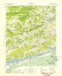
 1943 Holden Beach1962 Print · USGSCoastal Brunswick County is captured here in the 1940s, showing the quiet marshlands and river necks before significant shoreline development. Researchers can trace the roots of the barrier island at Holden Beach and find inland sites like Sivey Town and Sabbath Haven Ch.
 - 1943 Map of Exum, 1962 Print
 1943 Exum1962 Print · USGSBrunswick County at the height of the Second World War reveals a landscape defined by the deep reaches of the Green Swamp. Local historians can trace family ties at Union Ch and Milligan Cem, or follow the Old RR Grade through the timbered wetlands.
 - 1943 Map of Supply, 1962 Print
 1943 Supply1962 Print · USGSCoastal Brunswick County in the 1940s is defined by the vast Green Swamp and the small settlements emerging along its edges. Genealogists and researchers can trace local landmarks like Prospect Ch, Royal Oak Sch, and the Railroad Grade.2 unique versions available
 - 1943 Map of Shallotte, 1962 Print
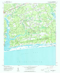
 1943 Shallotte1962 Print · USGSThe Brunswick County coast in the 1940s reveals a quiet network of tidal sounds and timberlands before modern development. Genealogists can trace family sites like Russtown, Register Cem, and local landmarks such as Brick Landing and Mintz Dam.
 - 1944 Map of Supply
 1944 Supply1944 Print · USGSBrunswick County during the Second World War shows a coastal landscape of timber roads and rural church communities. Trace family roots and local landmarks from Prospect to the Lockwoods Folly Bridge, including the Royal Oak School and Concord Church.
 - 1944 Map of Shallotte
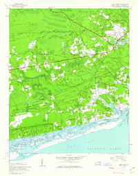
 1944 Shallotte1944 Print · USGSThe Brunswick County coast comes alive in the 1940s, showing the intricate tidal networks and small communities of the North Carolina shore. Trace local heritage through landmarks like Russtown, the Brunswick Co School, and the Coast Guard Station at the inlet.
 - 1949 Map of Georgetown, 1953 Print
 1949 Georgetown1953 Print · USGSThe South Carolina coast and North Carolina borderlands appear here in the mid-century, prior to the major modern development of the Grand Strand. Genealogists and historians can trace the rail networks of the Seaboard Air Line Railroad and locate coastal landmarks from Fort Caswell to McClellanville.
End of results
Showing maps 1-7 of 7
Top cities near Shallotte
- North Myrtle Beach historical maps
- Oak Island historical maps
- Sunset Beach historical maps
- Carolina Shores historical maps
- Holden Beach historical maps
- Calabash historical maps
See more
Top neighborhoods of Shallotte
Frequently asked questions
- What are the different types of historical maps available for Shallotte?
- What is the oldest map of Shallotte?
- Where can I purchase historical maps of Shallotte for my home or office?
- Where can I download high-res historical maps of Shallotte?
- Are there historical topographic maps available for Shallotte?
- Is there historical aerial imagery available for Shallotte?
- Where are historical maps of Shallotte sourced from?