1930s Maps of Black Mountain, North Carolina
Explore 2 historic maps of Black Mountain from the 1930s. These maps offer a rare glimpse into what life looked like during the 1930s — showing old roads, neighborhoods, homes, and landmarks that have changed or disappeared over time.
Whether you're researching your family's past, planning a metal detecting trip, or studying how Black Mountain's landscape evolved across the 1930s, these high-resolution maps are a powerful tool for exploring the history of this region.
- Focus on a specific era: All maps on this page are from the 1930s, giving you a focused view of this time period.
- See what’s changed: Compare century-old streets, trails, and buildings to today's modern landscape using overlays and satellite layers.
- Research with precision: Use these maps for genealogy, historical research, land use analysis, or educational projects.
- View, download, or print: Maps are fully viewable online in high resolution, and can be downloaded or printed for your own records.
Start exploring Black Mountain's history through authentic maps from the 1930s. This is your window into the past.
Black Mountain, NC maps
(2)- 1935 Map of Montreat
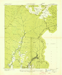 1935 Montreat1935 Print · USGSMontreat and the surrounding Black Mountains are shown here in the mid-1930s, documenting the area's religious centers and early park development. Genealogists and hikers can trace the Toll Road up to Clingmans Peak or locate old community landmarks like Brookside Sch and Homers Chapel.
 - 1935 Map of Black Mountain
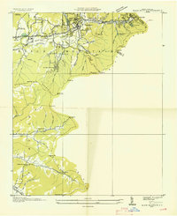 1935 Black Mountain1935 Print · USGSBuncombe County in the mid-1930s reveals a landscape shaped by mountain transit and social institutions. Genealogists can locate family landmarks like Tabernacle Ch, Pleasant Grove Sch, and the remote Mountain Orphanage along the rail-and-river corridor.
End of results
Showing maps 1-2 of 2
Top cities near Black Mountain
- Asheville historical maps
- Fletcher historical maps
- Mills River historical maps
- Swannanoa historical maps
- Royal Pines historical maps
- Woodfin historical maps
See more
Top neighborhoods of Black Mountain
Frequently asked questions
- What are the different types of historical maps available for Black Mountain?
- What is the oldest map of Black Mountain?
- Where can I purchase historical maps of Black Mountain for my home or office?
- Where can I download high-res historical maps of Black Mountain?
- Are there historical topographic maps available for Black Mountain?
- Is there historical aerial imagery available for Black Mountain?
- Where are historical maps of Black Mountain sourced from?