1970s Maps of Woodfin, North Carolina
Explore 2 historic maps of Woodfin from the 1970s. These maps offer a rare glimpse into what life looked like during the 1970s — showing old roads, neighborhoods, homes, and landmarks that have changed or disappeared over time.
Whether you're researching your family's past, planning a metal detecting trip, or studying how Woodfin's landscape evolved across the 1970s, these high-resolution maps are a powerful tool for exploring the history of this region.
- Focus on a specific era: All maps on this page are from the 1970s, giving you a focused view of this time period.
- See what’s changed: Compare century-old streets, trails, and buildings to today's modern landscape using overlays and satellite layers.
- Research with precision: Use these maps for genealogy, historical research, land use analysis, or educational projects.
- View, download, or print: Maps are fully viewable online in high resolution, and can be downloaded or printed for your own records.
Start exploring Woodfin's history through authentic maps from the 1970s. This is your window into the past.
Woodfin, NC maps
(2)- 1976 Map of Asheville, 1979 Print
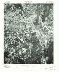 1976 Asheville1979 Print · USGSAsheville in the late seventies is shown in photographic detail as the city expanded across its mountain river valleys. Trace the growth of neighborhoods like West Asheville and Biltmore or the natural course of the French Broad River.
 - 1976 Map of Weaverville, 1979 Print
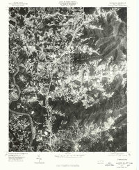 1976 Weaverville1979 Print · USGSThe northern corridor of the French Broad valley comes to life in this mid-seventies aerial survey. Researchers can trace land use and development patterns between Weaverville and Stocksville, or locate family sites near Reynolds Mountain.
End of results
Showing maps 1-2 of 2
Top cities near Woodfin
- Asheville historical maps
- Black Mountain historical maps
- Fletcher historical maps
- Mills River historical maps
- Swannanoa historical maps
- Royal Pines historical maps
See more
Top neighborhoods of Woodfin
Frequently asked questions
- What are the different types of historical maps available for Woodfin?
- What is the oldest map of Woodfin?
- Where can I purchase historical maps of Woodfin for my home or office?
- Where can I download high-res historical maps of Woodfin?
- Are there historical topographic maps available for Woodfin?
- Is there historical aerial imagery available for Woodfin?
- Where are historical maps of Woodfin sourced from?