1940s Maps of Cabarrus County, North Carolina
Explore 7 historic maps of Cabarrus County from the 1940s. These maps offer a rare glimpse into what life looked like during the 1940s — showing old roads, neighborhoods, homes, and landmarks that have changed or disappeared over time.
Whether you're researching your family's past, planning a metal detecting trip, or studying how Cabarrus County's landscape evolved across the 1940s, these high-resolution maps are a powerful tool for exploring the history of this region.
- Focus on a specific era: All maps on this page are from the 1940s, giving you a focused view of this time period.
- See what’s changed: Compare century-old streets, trails, and buildings to today's modern landscape using overlays and satellite layers.
- Research with precision: Use these maps for genealogy, historical research, land use analysis, or educational projects.
- View, download, or print: Maps are fully viewable online in high resolution, and can be downloaded or printed for your own records.
Start exploring Cabarrus County's history through authentic maps from the 1940s. This is your window into the past.
Cabarrus County, NC maps
(7)- 1941 Map of Charlotte
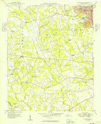
 1941 Charlotte1941 Print · USGSMecklenburg and its surrounding counties are captured here at a pivotal moment in the early 1940s. Genealogists and local historians can trace the rail-driven growth of Charlotte or locate smaller rural landmarks like Alexanders Store, Wesley Chapel, and the community at Stallings.
 - 1942 Map of Charlotte
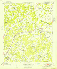
 1942 Charlotte1942 Print · USGSCharlotte and its surrounding Piedmont communities are captured here during the early years of the Second World War. Researchers can trace the rail corridors of the Southern and Seaboard Air Line or locate family-named sites like Alexanders Store, Hoods Cross Road, and Wesley Chapel.2 unique versions available
 - 1949 Map of Kannapolis
 1949 Kannapolis1949 Print · USGSCabarrus and Mecklenburg counties appear here in the late 1940s as the railroad-linked industrial core of Kannapolis expands. Genealogists and historians can trace long-standing rural landmarks like Poplar Tent Ch, Odell High Sch, and Cox Mill.
 - 1949 Map of Harrisburg
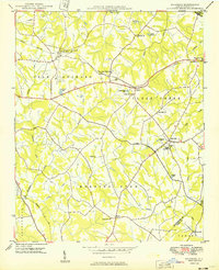
 1949 Harrisburg1949 Print · USGSThe rural borderlands between Cabarrus and Mecklenburg counties are captured here just after the war, centered on the Southern rail line. Researchers can trace ancestral locations at Back Creek Chapel, Roberta Mill, or the Newell High Sch.
 - 1949 Map of Wilgrove
 1949 Wilgrove1949 Print · USGSMecklenburg County’s rural townships are documented here during a period of steady mid-century growth. Researchers can trace ancestral locations near Mint Hill, the Delta Air Base, or early educational sites like Clear Creek Sch and Bain High Sch.2 unique versions available
 - 1949 Map of Midland
 1949 Midland1949 Print · USGSMidland and the surrounding Piedmont farm country are captured here in the late 1940s, just as rural electrification and improved roads were transforming the area. Local historians can trace old community hubs like the Midland Speedway, Emmanuel Cem, and the Rock Hill Sch.
 - 1949 Map of Concord SE
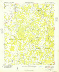 1949 Concord SE1949 Print · USGSSoutheast Cabarrus County in the late 1940s is a landscape of rural schoolhouses and family-run mills centered on the Rocky River. Researchers can trace the locations of old community hubs like Pioneer Mills, Flowes Store, and the Jackson Training Sch.
End of results
Showing maps 1-7 of 7
Top cities of Cabarrus County
- Concord historical maps
- Kannapolis historical maps
- Harrisburg historical maps
- Midland historical maps
- Mount Pleasant historical maps
Frequently asked questions
- What are the different types of historical maps available for Cabarrus County?
- What is the oldest map of Cabarrus County?
- Where can I purchase historical maps of Cabarrus County for my home or office?
- Where can I download high-res historical maps of Cabarrus County?
- Are there historical topographic maps available for Cabarrus County?
- Is there historical aerial imagery available for Cabarrus County?
- Where are historical maps of Cabarrus County sourced from?