1960s Maps of Cabarrus County, North Carolina
Explore 9 historic maps of Cabarrus County from the 1960s. These maps offer a rare glimpse into what life looked like during the 1960s — showing old roads, neighborhoods, homes, and landmarks that have changed or disappeared over time.
Whether you're researching your family's past, planning a metal detecting trip, or studying how Cabarrus County's landscape evolved across the 1960s, these high-resolution maps are a powerful tool for exploring the history of this region.
- Focus on a specific era: All maps on this page are from the 1960s, giving you a focused view of this time period.
- See what’s changed: Compare century-old streets, trails, and buildings to today's modern landscape using overlays and satellite layers.
- Research with precision: Use these maps for genealogy, historical research, land use analysis, or educational projects.
- View, download, or print: Maps are fully viewable online in high resolution, and can be downloaded or printed for your own records.
Start exploring Cabarrus County's history through authentic maps from the 1960s. This is your window into the past.
Cabarrus County, NC maps
(9)- 1960 Map of Charlotte
 1960 Charlotte1960 Print · USGSMid-century North Carolina and South Carolina meet in this 1960 survey of the Piedmont's industrial and textile heartland. Trace the growth of Charlotte alongside historic landmarks like Kings Mountain National Military Park and the Charlotte Naval Ammunition Depot.2 unique versions available
 - 1962 Map of Charlotte
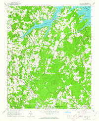
 1962 Charlotte1962 Print · USGSThe North Carolina Piedmont in the early sixties showcases a landscape transformed by massive reservoirs and industrial growth. Researchers can trace the development of Lake Norman, locate the Charlotte Naval Ammunition Depot, or find family landmarks like Wesley Chapel and Brown & Norcott Mills.
 - 1962 Map of Gold Hill, 1964 Print
 1962 Gold Hill1964 Print · USGSRowan County in the early sixties remains a landscape of quiet crossroads and riverside communities along the Yadkin River. Genealogists can trace family names and community roots through landmarks like St Peters Cem, Gold Hill Ch, and the settlement at Agner.3 unique versions available
 - 1962 Map of Rockwell, 1964 Print
 1962 Rockwell1964 Print · USGSRowan County and the Gold Hill region are shown in the early sixties during a period of active quarrying and rural growth. Genealogists can locate family landmarks like Old Stone House and historic sites such as Organ Ch or Shupings Mill.3 unique versions available
 - 1969 Map of Concord SE, 1972 Print
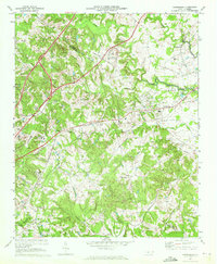
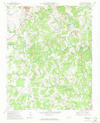 1969 Concord SE1972 Print · USGSThe rural Cabarrus County landscape of the late sixties is defined by the winding ROCKY RIVER and a network of historic crossroads. Researchers can trace the roots of local settlements and congregations at Pioneer Mills, Flows Store, and Zion Hill Ch.3 unique versions available
 - 1969 Map of Mooresville, 1972 Print
 1969 Mooresville1972 Print · USGSIredell County undergoes significant change in the late sixties as the waters of Lake Norman reach into the western valleys. Genealogists and local historians can trace the foundations of Davidson College and find old landmarks like Centre Ch and Mt Mourne.3 unique versions available
 - 1969 Map of Harrisburg, 1972 Print
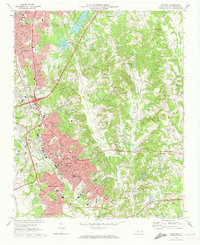
 1969 Harrisburg1972 Print · USGSThe Cabarrus and Mecklenburg county line near Harrisburg was entering a period of significant growth in the late sixties. Genealogists and local historians can trace the footprint of Roberta Mills, the early Univ of North Carolina at Charlotte, and Siloam Cem.2 unique versions available
 - 1969 Map of Kannapolis, 1972 Print
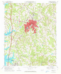
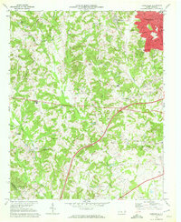 1969 Kannapolis1972 Print · USGSKannapolis and its rural North Carolina surroundings appear here in the late sixties as the area transitioned toward suburban growth. Researchers can locate early schools and cemeteries such as Shady Brook Sch, Bethpage Ch Cem, and Wallace Crossroads.2 unique versions available
 - 1969 Map of Concord, 1973 Print
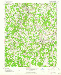
 1969 Concord1973 Print · USGSConcord and Kannapolis are captured during a mid-century period of rapid suburban growth and industrial stability. Genealogists can trace family roots through neighborhood landmarks like Heilmans Mill, St James Cem, and Barber-Scotia College.2 unique versions available
End of results
Showing maps 1-9 of 9
Top cities of Cabarrus County
- Concord historical maps
- Kannapolis historical maps
- Harrisburg historical maps
- Midland historical maps
- Mount Pleasant historical maps
Frequently asked questions
- What are the different types of historical maps available for Cabarrus County?
- What is the oldest map of Cabarrus County?
- Where can I purchase historical maps of Cabarrus County for my home or office?
- Where can I download high-res historical maps of Cabarrus County?
- Are there historical topographic maps available for Cabarrus County?
- Is there historical aerial imagery available for Cabarrus County?
- Where are historical maps of Cabarrus County sourced from?