1980s Maps of Carteret County, North Carolina
Explore 5 historic maps of Carteret County from the 1980s. These maps offer a rare glimpse into what life looked like during the 1980s — showing old roads, neighborhoods, homes, and landmarks that have changed or disappeared over time.
Whether you're researching your family's past, planning a metal detecting trip, or studying how Carteret County's landscape evolved across the 1980s, these high-resolution maps are a powerful tool for exploring the history of this region.
- Focus on a specific era: All maps on this page are from the 1980s, giving you a focused view of this time period.
- See what’s changed: Compare century-old streets, trails, and buildings to today's modern landscape using overlays and satellite layers.
- Research with precision: Use these maps for genealogy, historical research, land use analysis, or educational projects.
- View, download, or print: Maps are fully viewable online in high resolution, and can be downloaded or printed for your own records.
Start exploring Carteret County's history through authentic maps from the 1980s. This is your window into the past.
Carteret County, NC maps
(5)- 1984 Map of Hadnot Creek
 1984 Hadnot Creek1984 Print · USGSThe coastal forest and wetlands of Carteret and Jones counties are captured here in the mid-1980s. Local researchers can trace the drainages of the White Oak River and locate small family cemeteries near Hadnot Creek and Wolf Swamp.
 - 1984 Map of Stella
 1984 Stella1984 Print · USGSCoastal North Carolina river life and military borders intersect in the 1980s along the winding White Oak River. Researchers can trace rural lineages through local landmarks like Silverdale, Davis Chapel, and the riverside community of Stella.2 unique versions available
 - 1985 Map of Morehead City
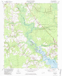
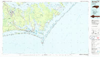 1985 Morehead City1985 Print · USGSCoastal Carteret County in the 1980s reveals a transition from military installations and industrial hubs to protected wilderness along the Outer Banks. Researchers can trace the development of Morehead City and Beaufort or explore the remote stretches of Shackleford Banks and Harkers Island.
 - 1985 Map of Bayboro, 1990 Print
 1985 Bayboro1990 Print · USGSCoastal Pamlico and Beaufort counties are shown in the mid-eighties as a maritime landscape of protected wetlands and river-mouth settlements. Researchers can trace the layout of waterfront towns like Oriental, Bayboro, and the historic village of Bath amidst the Pamlico Sound.
 - 1986 Map of New River
 1986 New River1986 Print · USGSCoastal Onslow County in the mid-eighties shows a landscape shaped by military expansion and the preserved wetlands of the Carolina coast. Genealogists and historians can trace the foundations of Jacksonville and small outlying communities like Richlands and Swansboro.
End of results
Showing maps 1-5 of 5
Top cities of Carteret County
- Morehead City historical maps
- Newport historical maps
- Emerald Isle historical maps
- Cape Carteret historical maps
- Atlantic Beach historical maps
- Cedar Point historical maps
See more
Frequently asked questions
- What are the different types of historical maps available for Carteret County?
- What is the oldest map of Carteret County?
- Where can I purchase historical maps of Carteret County for my home or office?
- Where can I download high-res historical maps of Carteret County?
- Are there historical topographic maps available for Carteret County?
- Is there historical aerial imagery available for Carteret County?
- Where are historical maps of Carteret County sourced from?