1970s Maps of Yanceyville, North Carolina
Explore 2 historic maps of Yanceyville from the 1970s. These maps offer a rare glimpse into what life looked like during the 1970s — showing old roads, neighborhoods, homes, and landmarks that have changed or disappeared over time.
Whether you're researching your family's past, planning a metal detecting trip, or studying how Yanceyville's landscape evolved across the 1970s, these high-resolution maps are a powerful tool for exploring the history of this region.
- Focus on a specific era: All maps on this page are from the 1970s, giving you a focused view of this time period.
- See what’s changed: Compare century-old streets, trails, and buildings to today's modern landscape using overlays and satellite layers.
- Research with precision: Use these maps for genealogy, historical research, land use analysis, or educational projects.
- View, download, or print: Maps are fully viewable online in high resolution, and can be downloaded or printed for your own records.
Start exploring Yanceyville's history through authentic maps from the 1970s. This is your window into the past.
Yanceyville, NC maps
(2)- 1972 Map of Park Spring, 1974 Print
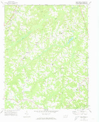 1972 Park Spring1974 Print · USGSCaswell County's rural character is captured here in the early 1970s, showing a landscape of small settlements and dispersed country congregations. Researchers can trace family roots through landmarks like Gwynns Chapel, New Ephesus Ch, and the Cobb Memorial Sch near Blackwell.3 unique versions available
 - 1972 Map of Yanceyville, 1974 Print
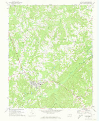 1972 Yanceyville1974 Print · USGSCaswell County remains a predominantly rural landscape during the early 1970s, centered on the growing county seat. Researchers can find many genealogy landmarks, including Piedmont Academy, Pearson Chapel, and the old Prison Camp near the Fairgrounds.2 unique versions available
End of results
Showing maps 1-2 of 2
Top cities near Yanceyville
Frequently asked questions
- What are the different types of historical maps available for Yanceyville?
- What is the oldest map of Yanceyville?
- Where can I purchase historical maps of Yanceyville for my home or office?
- Where can I download high-res historical maps of Yanceyville?
- Are there historical topographic maps available for Yanceyville?
- Is there historical aerial imagery available for Yanceyville?
- Where are historical maps of Yanceyville sourced from?