1990s Maps of Catawba County, North Carolina
Explore 10 historic maps of Catawba County from the 1990s. These maps offer a rare glimpse into what life looked like during the 1990s — showing old roads, neighborhoods, homes, and landmarks that have changed or disappeared over time.
Whether you're researching your family's past, planning a metal detecting trip, or studying how Catawba County's landscape evolved across the 1990s, these high-resolution maps are a powerful tool for exploring the history of this region.
- Focus on a specific era: All maps on this page are from the 1990s, giving you a focused view of this time period.
- See what’s changed: Compare century-old streets, trails, and buildings to today's modern landscape using overlays and satellite layers.
- Research with precision: Use these maps for genealogy, historical research, land use analysis, or educational projects.
- View, download, or print: Maps are fully viewable online in high resolution, and can be downloaded or printed for your own records.
Start exploring Catawba County's history through authentic maps from the 1990s. This is your window into the past.
Catawba County, NC maps
(10)- 1993 Map of Bethlehem, 1996 Print
 1993 Bethlehem1996 Print · USGSLake Hickory and the Catawba River divided three North Carolina counties during this period of suburban expansion. Researchers can trace family history through numerous rural landmarks like Bentley Cem, Petra Mills, and St Stephens High Sch.
 - 1993 Map of Denver, 1996 Print
 1993 Denver1996 Print · USGSThe foothills of the Piedmont in the early nineties show the rural character of the Catawba and Lincoln county line before rapid suburbanization. Local historians can trace family roots through numerous sites like Friendly Cem, Drums Crossroads, and Thompson Memorial Ch.
 - 1993 Map of Newton, 1996 Print
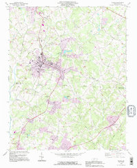
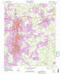 1993 Newton1996 Print · USGSCatawba County's urban and rural landscape is shown in detail during the mid-nineties as the towns of Newton and Conover expanded. Researchers can find numerous family-named churches and schools, including Old St Pauls Ch, Thornton Sch, and Smyre.
 - 1993 Map of Granite Falls, 1996 Print
 1993 Granite Falls1996 Print · USGSThe Catawba River valley in the early nineties shows the transformation of the landscape by the impounded Rhodhiss Lake. Genealogists and local historians can trace rural roots at Sunset Hill Cem or find landmarks like the Hudson Drag Strip.
 - 1993 Map of Lake Norman North, 1996 Print
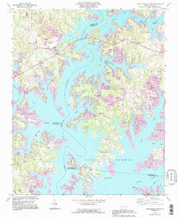 1993 Lake Norman North1996 Print · USGSThe Catawba River valley in the early nineties shows a landscape transformed by reservoir waters and residential growth. Researchers can trace older landmarks like Sherrills Ford and Webbs Chapel or locate the Williamson Cem along the winding shores of Lake Norman.
 - 1993 Map of Troutman, 1996 Print
 1993 Troutman1996 Print · USGSThe Catawba River valley and the expanding shores of Lake Norman are captured here in the mid-nineties. Researchers can locate long-standing community centers like Barium Springs, the Home for Children, and numerous family-linked sites including Troutman Cem.
 - 1993 Map of Maiden, 1996 Print
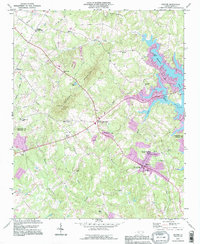
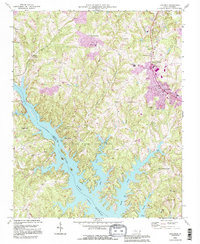
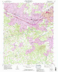
 1993 Maiden1996 Print · USGSThe industrial and rail-centered town of Maiden sits at the heart of this mid-1990s survey on the Catawba and Lincoln county line. Researchers can trace local heritage through numerous rural landmarks like Providence Mill, Pumpkin Center, and Lawnings Chapel.2 unique versions available
 - 1993 Map of Hickory, 1996 Print
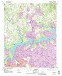
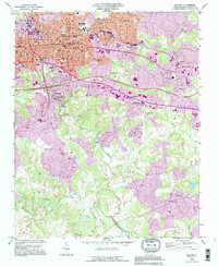 1993 Hickory1996 Print · USGSHickory and its surrounding Catawba County communities are captured here in the mid-1990s as the region experienced significant growth. Researchers can trace historic family burial sites at Old Robinson Cem or locate local landmarks like Lenoir Rhyne College and the Hickory Speedway.
 - 1993 Map of Longview, 1996 Print
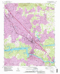
 1993 Longview1996 Print · USGSThe borderlands of Burke and Catawba counties come into focus during the mid-1990s as suburban growth reaches into the river valleys. Genealogists and local historians can trace family roots through numerous landmarks like Burke Chapel, Propst Crossroads, and Icard.
 - 1997 Map of Catawba, 2000 Print
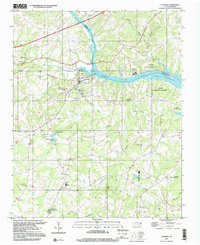 1997 Catawba2000 Print · USGSThe Catawba River valley in the late twentieth century reveals a landscape where historic milling and rural education meet modern recreation. Researchers can locate the Bunker Hill Covered Bridge, the Catawba Rosenwald Sch, and family sites like Smyres Cem.
End of results
Showing maps 1-10 of 10
Top cities of Catawba County
- Hickory historical maps
- Newton historical maps
- Conover historical maps
- Long View historical maps
- Maiden historical maps
- Claremont historical maps
See more
Frequently asked questions
- What are the different types of historical maps available for Catawba County?
- What is the oldest map of Catawba County?
- Where can I purchase historical maps of Catawba County for my home or office?
- Where can I download high-res historical maps of Catawba County?
- Are there historical topographic maps available for Catawba County?
- Is there historical aerial imagery available for Catawba County?
- Where are historical maps of Catawba County sourced from?